
Temperatures this week will have daytime highs back in the 20s and 30s. A couple of chances at snow are also possible before another, brief, arctic blast.Snow showers TuesdayTuesday will be slightly warmer with morning temperatures near 20 and highs pushing toward 30. This will be our first chance to see highs reach freezing. A system will pass to our south late in the day to bring some snow showers. It looks like the snow will generally remain south of Interstate 70 with the best chance of seeing snow along the Interstate 68 corridor. Here, a Winter Weather Advisory is up for Monongalia, Garrett, and Preston Counties.Any accumulations will be less than an inch. A fresh batch of Arctic air arrives as this system departs. Lows will return to the single digits with highs in the teens for Wednesday and Thursday. Fortunately, the wind will remain light so the wind chill shouldn’t be much of a factor over these frigid starts. Impact Days through the weekend for snow then coldThe next system to watch could bring more snow to western Pennsylvania on Friday. At this point, the long-range forecast suggests 1-3″ of snow is possible. We will keep you updated on the trends. While Friday will be the “snowiest” day of the week, it will also be the “warmest” with a high near 30 degrees. This storm will unlock another bitter blast with highs returning to the teens next weekend and lows into the single digits. This cold blast is short-lived as highs finally break freezing early next week.TODAY: Sun and clouds with flurries. High: 26°.TONIGHT: Mostly cloudy, isolated flurries. Low 20°TUESDAY: Isolated snow showers south. Cloudy and not as cold. High: 30°, low: 7°.WEDNESDAY: Colder with gray skies. High: 22°, low: 5°.
PITTSBURGH —
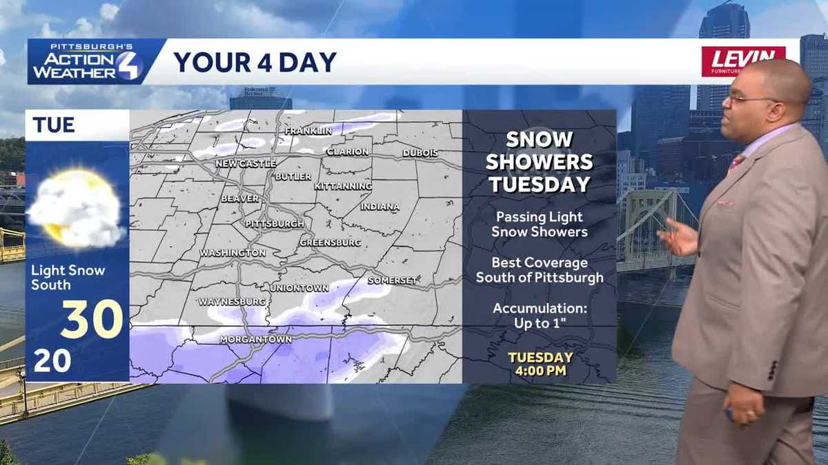
Temperatures this week will have daytime highs back in the 20s and 30s. A couple of chances at snow are also possible before another, brief, arctic blast.
Snow showers Tuesday
Tuesday will be slightly warmer with morning temperatures near 20 and highs pushing toward 30. This will be our first chance to see highs reach freezing. A system will pass to our south late in the day to bring some snow showers. It looks like the snow will generally remain south of Interstate 70 with the best chance of seeing snow along the Interstate 68 corridor. Here, a Winter Weather Advisory is up for Monongalia, Garrett, and Preston Counties.

Hearst Owned
Winter Weather Advisory for the I-68 corridor for snow Tuesday into early Wednesday.
Any accumulations will be less than an inch. A fresh batch of Arctic air arrives as this system departs. Lows will return to the single digits with highs in the teens for Wednesday and Thursday. Fortunately, the wind will remain light so the wind chill shouldn’t be much of a factor over these frigid starts.
Impact Days through the weekend for snow then cold
The next system to watch could bring more snow to western Pennsylvania on Friday. At this point, the long-range forecast suggests 1-3″ of snow is possible. We will keep you updated on the trends. While Friday will be the “snowiest” day of the week, it will also be the “warmest” with a high near 30 degrees.

Hearst Owned
Snow showers will be around through the day on Friday with accumulations of one to three inches likely.
This storm will unlock another bitter blast with highs returning to the teens next weekend and lows into the single digits. This cold blast is short-lived as highs finally break freezing early next week.

Hearst Owned
Roller coaster temperatures with a trio of Impact Days this weekend for snow and cold.
TODAY: Sun and clouds with flurries. High: 26°.
TONIGHT: Mostly cloudy, isolated flurries. Low 20°
TUESDAY: Isolated snow showers south. Cloudy and not as cold. High: 30°, low: 7°.
WEDNESDAY: Colder with gray skies. High: 22°, low: 5°.