
Less-Intense Winter Chill, Few Snow Showers Late Tuesday In South Central Pennsylvania
Temperatures climb above freezing on Tuesday afternoon, with isolated snow showers returning Tuesday evening after sunset. Little to no accumulation is expected. Higher snow chances return Friday.
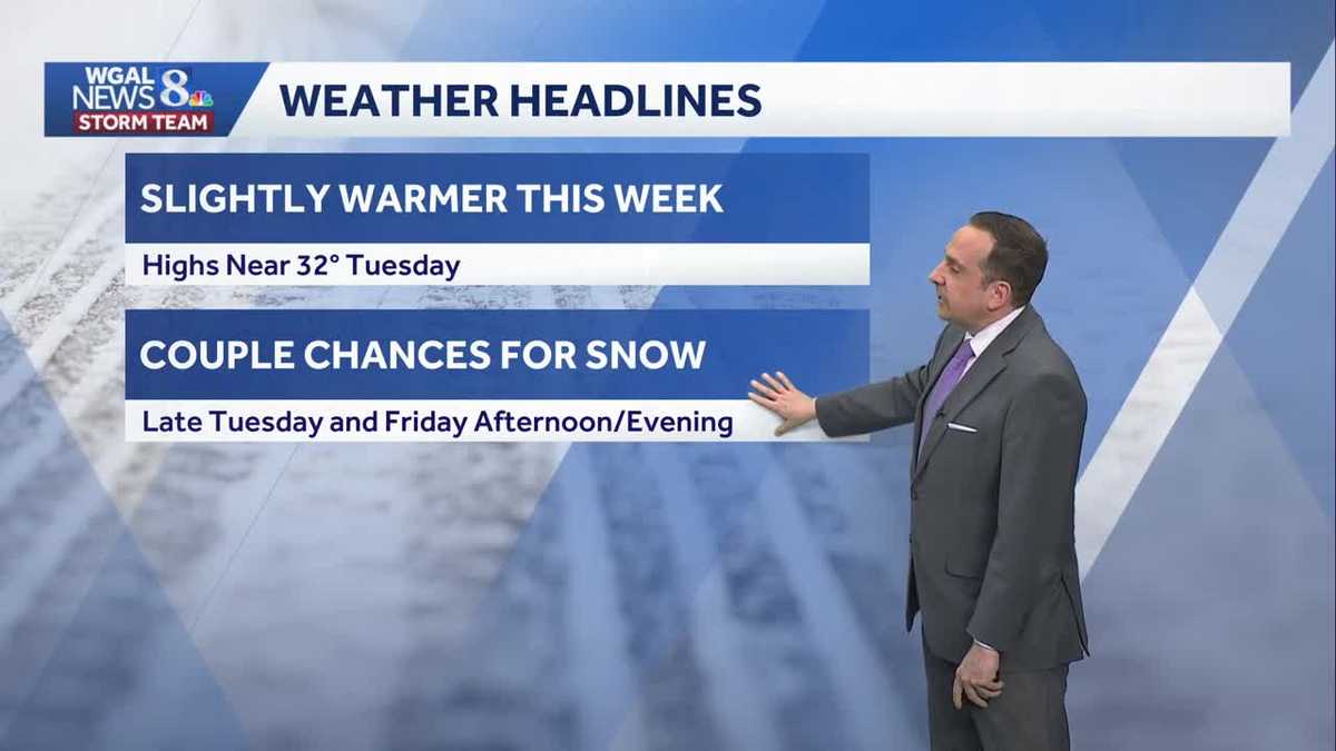
PAGE, WHICH IS BRIAN ROCHE WGAL. NOW THE WGAL NEWS EIGHT STORM TEAM FORECAST WITH METEOROLOGIST ETHAN HUSTON. HAPPY GROUNDHOG DAY. TEMPERATURES HAVE BEEN TRENDING UPWARD AND IT IS GOING TO BE A LITTLE WARMER THAN THE PAST A WEEK OR SO, BUT WE’RE STILL GOING TO BE WELL BELOW AVERAGE. SO I’M CALLING IT A LESS INTENSE CHILL THROUGH TUESDAY INTO WEDNESDAY WITH TEMPERATURES NEAR THE FREEZING MARK. COULD SEE A FEW OPPORTUNITIES FOR SOME SNOW. THE NEXT BEST ONE WILL BE TOMORROW IN THE FORM OF SOME SPOTTY LIGHT SNOW SHOWERS, AND THEN AGAIN HEADING INTO FRIDAY AFTERNOON AND EVENING, WE’LL HAVE AT LEAST A CHANCE FOR MORE WIDESPREAD SNOW. THEN HERE COMES THAT ARCTIC CHILL ONCE AGAIN. WE’RE TALKING TEMPERATURES BACK DOWN INTO THE TEENS TO LOWER 20S FOR THE WEEKEND. OUTSIDE RIGHT NOW, SKIES ARE CLEAR. IT IS COLD OUT THERE. WE’RE AT 28 DEGREES, BUT IT’S A SEASONAL CHILL WITH FEELS LIKE TEMPERATURES RIGHT NOW IN THE RED ROSE CITY AT 22 DEGREES. WE’LL START TO SEE SOME CLOUDS ROLL IN THANKS TO A DISTURBANCE COMING IN FROM WESTERN PA. TEMPERATURES WILL BE DOWN TO RIGHT AROUND 20 DEGREES LATER THIS EVENING. LOWS TONIGHT WILL BE DOWN INTO THE TEENS, BUT THE CHILL WILL BE LESS INTENSE BECAUSE THE WINDS WILL BE RELATIVELY LIGHT. MAY SEE SOME FLURRIES AS WE GO THROUGH LATE THIS EVENING INTO THE OVERNIGHT HOURS. THANKS TO THAT PASSING DISTURBANCE. AND THEN FOR TOMORROW IT IS GOING TO BE FAIRLY CLOUDY. WE’LL SEE SOME PEEKS OF SUNSHINE. TEMPERATURES WILL BE AT OR ABOVE FREEZING FOR HIGHS. AND THEN AS WE GET CLOSER TO SUNSET INTO THE EARLY OVERNIGHT HOURS, MAY SEE SOME VERY ISOLATED LIGHT SNOW SHOWERS. WINDOW OF OPPORTUNITY FOR THOSE WILL BE BETWEEN 6:00 TOMORROW EVENING UNTIL 6 A.M. ON WEDNESDAY, AND THEY’RE NOT GOING TO AMOUNT TO MUCH TALKING LESS THAN AN INCH OF SNOW. EVEN IF YOU DO SEE THAT SNOW COMING DOWN, THE BEST CHANCE FOR THOSE WILL BE SOUTH OF THE TURNPIKE, SO THERE COULD BE SOME LOCALIZED SNOW COVERED OR SLIPPERY ROADS JUST IN AREAS NOT LOOKING FOR ANY WIDESPREAD IMPACTS. YOU CAN SEE THAT HERE ON THE PREDICTOR. THE BEST CHANCE FOR ACCUMULATING SNOW TOMORROW WILL BE WEST OF I 99 AND JUST SPOTTY IN NATURE ACROSS THE SUSQUEHANNA VALLEY. BUT THAT DEEP WINTER CHILL THAT’S GOING TO BE AROUND FOR THE WEEKEND FOR YOUR SATURDAY AND SUNDAY HIGHS ONLY IN THE TEENS TO RIGHT AROUND 20 DEGREES. BUT TODAY WE MADE IT TO THE FREEZING MARK, MADE IT TO 32 DEGREES, AND THE SNOW DEPTH AT THE AIRPORT IS NOW JUST SIX INCHES. THAT IS ABOUT HALF OF WHAT THE STORM GAVE US TWO WEEKENDS AGO. SO THE STREAK ENDS AT NINE DAYS, WHERE WE HAD TEMPERATURES STAY BELOW FREEZING SINCE WE TOUCHED THE FREEZING MARK TODAY, THAT ENDS THE STREAK RIGHT NOW IN CAMP HILL, IT’S 30 DEGREES 25 RIGHT NOW IN HARRISBURG, 28 CURRENTLY IN LANCASTER, 30 IF YOU’RE WATCHING US IN GREENCASTLE. GOT A LITTLE BIT OF A BREEZE OUT THERE. ANYWHERE FROM FIVE TO ABOUT TEN MILES PER HOUR PUSHING THOSE FEELS LIKE TEMPERATURES DOWN INTO THE TEENS TO 20S ACROSS MUCH OF THE SUSQUEHANNA VALLEY FEELS EVEN COLDER OFF TO OUR WEST 11 RIGHT NOW IN DUBOIS, 16 CURRENTLY IN PITTSBURGH, AND IT’S OUT TOWARDS PITTSBURGH. WE ARE TRACKING THESE ISOLATED SNOW SHOWERS, SO THIS DISTURBANCE IS WHAT’S GOING TO BRING THE CLOUD COVER IN ACROSS THE VALLEY AGAIN. MAY SEE A FEW FLAKES FLYING AT TIMES, BUT I DON’T EXPECT ANY ACCUMULATION. WHAT WE’RE WATCHING FOR TOMORROW IS BACK OVER MICHIGAN, ASSOCIATED WITH AN INCOMING COLD FRONT. SO WATCH HERE ON THE PREDICTOR. HERE COME THE CLOUDS. AND AS WE GO THROUGH TOMORROW, IT’S ONCE WE GET CLOSER TO SUNSET, WE’LL HAVE AT LEAST THE OPPORTUNITY FOR THESE ISOLATED SNOW SHOWERS. I THINK THE BEST CHANCE FOR STEADY SNOW WILL BE OFF TO OUR SOUTH OVER WEST VIRGINIA, VIRGINIA, AND FAR SOUTHERN PORTIONS OF MARYLAND. NOW HEADING INTO THE WEEKEND, THAT’S WHEN WE HAVE THE BETTER OPPORTUNITY FOR THESE SPOTTY SNOW SHOWERS. THAT BECOMES A BIT MORE WIDESPREAD LATE IN THE DAY ON FRIDAY, BUT THERE YOU CAN SEE DRY WEATHER FOR SUPER BOWL WEEKEND, BUT IT IS GOING TO BE COLD TEMPERATURES ON SUPER BOWL SUNDAY RIGHT AROUND AT 20 DEGREES. WE DO SEE A LITTLE BIT OF A WARM UP AS WE GO INTO MID TO LATE NEXT WEEK. BUT
Less-Intense Winter Chill, Few Snow Showers Late Tuesday In South Central Pennsylvania
Temperatures climb above freezing on Tuesday afternoon, with isolated snow showers returning Tuesday evening after sunset. Little to no accumulation is expected. Higher snow chances return Friday.

Updated: 6:26 PM EST Feb 2, 2026
Tonight, clouds will increase, and winds will be light, allowing temperatures to fall to the low-to-mid teens.Calmer and cloudier conditions are in store on Tuesday. Highs will finally warm to the freezing mark, if not a few degrees above. After a 10-day stretch below freezing, this will be a nice break!A quick-moving system will pass to our south Tuesday evening through Tuesday night, leading to a chance of light snow showers. Snow will be gone by sunrise on Wednesday. Expect a coating to an inch of snow if you see the snow showers late Tuesday. The best window of opportunity will be roughly from 6 PM to 6 AM and the best place to see the snow showers will be south of the Pennsylvania Turnpike. Wednesday will feature mostly sunny skies and highs near freezing. A 5-15 mph breeze will put a chill in the air.Thursday will be blustery and cold. Highs will reach the upper 20s, but it will feel like the teens.We’re watching a clipper, which could bring light snow across the area Friday afternoon and evening. It will turn windy and much colder behind that system, leading to highs in the low 20s and lows in the single digits over the weekend, along with harsh wind chills. The cold isn’t done with us yet!However, next week, temperatures gradually moderate to near freezing again Tuesday and Wednesday. There’s a chance of a wintry mix on Wednesday.
Tonight, clouds will increase, and winds will be light, allowing temperatures to fall to the low-to-mid teens.
Calmer and cloudier conditions are in store on Tuesday. Highs will finally warm to the freezing mark, if not a few degrees above. After a 10-day stretch below freezing, this will be a nice break!
A quick-moving system will pass to our south Tuesday evening through Tuesday night, leading to a chance of light snow showers. Snow will be gone by sunrise on Wednesday. Expect a coating to an inch of snow if you see the snow showers late Tuesday. The best window of opportunity will be roughly from 6 PM to 6 AM and the best place to see the snow showers will be south of the Pennsylvania Turnpike.
Wednesday will feature mostly sunny skies and highs near freezing. A 5-15 mph breeze will put a chill in the air.
Thursday will be blustery and cold. Highs will reach the upper 20s, but it will feel like the teens.
We’re watching a clipper, which could bring light snow across the area Friday afternoon and evening. It will turn windy and much colder behind that system, leading to highs in the low 20s and lows in the single digits over the weekend, along with harsh wind chills. The cold isn’t done with us yet!
However, next week, temperatures gradually moderate to near freezing again Tuesday and Wednesday. There’s a chance of a wintry mix on Wednesday.