
Western PA: Passing flakes before colder air returns
Morning lows in the single digits and highs in the 20s are ahead for the middle of the week.
BUSINESSES IN THE DAIRY INDUSTRY. THE CHANGE JUST MADE SENSE. FOR THE FIRST TIME IN WELL OVER A WEEK. WE DON’T HAVE AN IMPACT DAY OR AN ALERT DAY, AND IN FACT, TODAY IS GOING TO BE A LITTLE EASIER TO HANDLE AS TEMPERATURES WILL BE CLIMBING CLOSE TO 30 DEGREES ACROSS WESTERN PENNSYLVANIA MAY EVEN CRACK FREEZING AS WE LOOK CLOSER TO THE WEST VIRGINIA BORDER. SPEAKING OF SOUTH, YOU HAVE A BETTER CHANCE TO SEE SOME PASSING SNOW SHOWERS TODAY SHOULD BE GENERALLY LIGHT, BUT COULD IMPACT THE EVENING COMMUTE. WE WILL SEE MORE SNOW AREAWIDE BY FRIDAY. THAT LEADS US TO YET ANOTHER FRIGID WEEKEND. CHECK OUT THESE HIGH TEMPERATURES. WANT TO BRACE YOURSELF FOR THIS? ONLY THE TEENS ON SATURDAY A HIGH OF 20 ON SUNDAY, BUT FORTUNATELY IT LOOKS LIKE THAT ARCTIC BURST IS JUST GOING TO BE A BRIEF ONE AS WE GO INTO THE WEEKEND. EVEN OUR STARTING POINT THIS MORNING, WAY WARMER THAN YESTERDAY. STILL HOLDING ON TO THE TEENS IN FRANKLIN AND DUBOIS, BUT EVERYBODY ELSE LOW AND MID 20S HAVEN’T SAID THAT MUCH RECENTLY. IT’S 24 IN PITTSBURGH. ALSO FOR WASHINGTON. A PAIR OF TWOS AS YOU GET THE DAY STARTED IN KITTANNING 25 DOWN TOWARDS MORGANTOWN. HERE’S A QUICK LOOK AT YOUR 4-DAY PLUS 4 MORE FORECAST SOME PASSING FLURRIES ALREADY SEEING SOME ACTION HERE THIS MORNING. MORE SNOW WILL DEVELOP AS THE DAY GOES ON, ESPECIALLY SOUTH OF THE CITY, BUT NOT AS COLD 30 FOR A HIGH. WE WILL BACKPEDAL INTO THE 20S WEDNESDAY AND THURSDAY, THEN IMPACT DAYS RETURN ON FRIDAY AS WE’LL SEE SOME AREA WIDE LIGHT SNOW AGAIN. THAT DOES LEAD TO A FRIGID WEEKEND, BUT TEMPERATURES WILL BE BOUNCING BACK PRETTY QUICKLY INTO NEXT WEEK AGAIN. ALREADY SEEING SOME BURSTS OF SNOW, IT IS A LITTLE BIT STEADIER AS LOOK AROUND CRANBERRY, SO IMPACTING PARTS OF 279 THE TURNPIKE. ALSO 228 THAT EXTENDS TOWARDS ROUTE EIGHT AND NORTHERN ALLEGHENY COUNTY. EVEN WORKING ALONG THE TURNPIKE AND ALSO ROUTE 19 AND 910. AS WE WIDEN OUT THE VIEW COMING OUT OF ELIZABETH AND FORD TOWNSHIPS, WORKING TOWARDS NORTH HUNTINGDON, GREENSBURG, RIGHT ALONG ROUTE 30, EVEN TOWARDS LATROBE, YOU COULD ALSO SEE SOME STEADIER SNOW, AND THAT COULD PRODUCE A QUICK LITTLE COATING, MAKE THINGS A LITTLE SLIPPERY, ESPECIALLY IF ROADS WEREN’T TREATED FOR THE OVERNIGHT HOURS. BUT FOR THE MOST PART, WE’RE JUST SEEING THOSE FLURRIES FLYING ACROSS THE REGION AS WE GO THROUGHOUT THE DAY AND WE WILL SEE SOME IMPROVEMENTS IN OUR TEMPERATURES ON OUR WAY CLOSE TO 30, ESPECIALLY TOWARDS AFTER SCHOOL TIME. WE’LL SEE SOME OF THOSE SNOW SHOWERS STARTING TO DEVELOP. BULK OF THE ACTION, THOUGH, IS GOING TO SKIRT US JUST TO THE SOUTH INTO PARTS OF WEST VIRGINIA. THAT WRAPS UP PRETTY QUICKLY AS WE HEAD INTO THE EVENING AND OVERNIGHT HOURS. AS WE FAST FORWARD INTO THE MORNING TOMORROW, SINGLE DIGIT TEMPERATURES ARE BACK. WE’RE ONLY GOING TO BE IN THE 20S FOR HIGHS TOMORROW AND THURSDAY, BUT THEN THINGS WILL SLOWLY IMPROVE BY THE TIME WE HIT FRIDAY, MORE SNOW SHOWERS WILL BE POSSIBLE ON THE IMPACT DAY. THIS IS A CLIPPER SYSTEM, SO WILL BE IN AND OUT PRETTY QUICKLY. COULD PRODUCE 1 TO 3IN ACROSS THE AREA. SO WE’RE GOING TO CONTINUE TO MONITOR THAT TREND AND PINPOINT WHICH NEIGHBORHOODS COULD BE A LITTLE BIT ON THE HIGHER SIDE. AGAIN, IN YOUR 4-DAY PLUS 4 MORE FORECAST, THAT FRIGID FEELING IS BACK OVER THE WEEKEND.
Western PA: Passing flakes before colder air returns
Morning lows in the single digits and highs in the 20s are ahead for the middle of the week.

Updated: 5:15 AM EST Feb 3, 2026
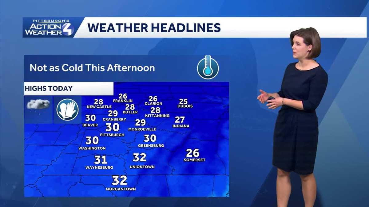
Temperatures this week will have daytime highs back in the 20s and 30s. A couple of chances at snow are also possible before another, brief, arctic blast.Flurries, light snow south todayYou can leave your heaviest winter coat in the closet. Temperatures this morning are near 20° and highs push close to 30 degrees. This will be our first chance to get close to the freezing mark. A system will pass to our south late in the day bringing some snow showers. It looks like the snow will generally remain south of Interstate 70 with the best chance of seeing snow along the Interstate 68 corridor. A Winter Weather Advisory is up for Monongalia, Garrett, and Preston counties between 10 a.m. and 1 a.m. Wednesday. Accumulations will be between one and two inches in northern West Virginia.A fresh batch of Arctic air arrives as this system departs. Lows will return to the single digits with highs in the teens for Wednesday and Thursday. Fortunately, the wind will remain light so the wind chill shouldn’t be much of a factor over these frigid starts.More snow for all on FridayA clipper will bring more snow to western Pennsylvania on Friday. It is an Impact Day for the potential for 1-3″ of snow. Some of the steadiest snow will impact the afternoon and evening commute.Brief Arctic blast over the weekendThe Impact Days will extend into the weekend with the return of much colder air. Highs return to the teens with single digit lows. Despite the bitter cold, it will be a snow-free weekend. This cold blast is short-lived as highs finally break freezing early next week for the Pittsburgh area.TUESDAY: Isolated snow showers south. Cloudy and not as cold. High: 30°, low: 7°.WEDNESDAY: Colder with gradual clearing. High: 24°, low: 6°.THURSDAY: Still quite cold with increasing clouds. High: 23°, low: 12°.FRIDAY – Impact Day: Snow showers. High: 30°, low: 5°.
PITTSBURGH —
Temperatures this week will have daytime highs back in the 20s and 30s. A couple of chances at snow are also possible before another, brief, arctic blast.
Flurries, light snow south today
You can leave your heaviest winter coat in the closet. Temperatures this morning are near 20° and highs push close to 30 degrees. This will be our first chance to get close to the freezing mark. A system will pass to our south late in the day bringing some snow showers. It looks like the snow will generally remain south of Interstate 70 with the best chance of seeing snow along the Interstate 68 corridor.

Hearst OwnedHearst
Today’s best snow chance is for northern West Virginia. Snow showers could slow your evening drive.
A Winter Weather Advisory is up for Monongalia, Garrett, and Preston counties between 10 a.m. and 1 a.m. Wednesday. Accumulations will be between one and two inches in northern West Virginia.

Hearst OwnedHearst
A Winter Weather Advisory for light snow in northern West Virginia and Garrett County.
A fresh batch of Arctic air arrives as this system departs. Lows will return to the single digits with highs in the teens for Wednesday and Thursday. Fortunately, the wind will remain light so the wind chill shouldn’t be much of a factor over these frigid starts.
More snow for all on Friday
A clipper will bring more snow to western Pennsylvania on Friday. It is an Impact Day for the potential for 1-3″ of snow. Some of the steadiest snow will impact the afternoon and evening commute.

Hearst OwnedHearst
An Impact Day on Friday for light snow then an impact weekend with another Arctic blast.
Brief Arctic blast over the weekend
The Impact Days will extend into the weekend with the return of much colder air. Highs return to the teens with single digit lows. Despite the bitter cold, it will be a snow-free weekend. This cold blast is short-lived as highs finally break freezing early next week for the Pittsburgh area.

Hearst OwnedHearst
Brief colder snaps for the middle of the week and again over the weekend. Temperatures could climb above freezing as early as next Tuesday.
TUESDAY: Isolated snow showers south. Cloudy and not as cold. High: 30°, low: 7°.
WEDNESDAY: Colder with gradual clearing. High: 24°, low: 6°.
THURSDAY: Still quite cold with increasing clouds. High: 23°, low: 12°.
FRIDAY – Impact Day: Snow showers. High: 30°, low: 5°.