
Not As Cold Today; Light Snow Friday In South Central Pennsylvania
Isolated snow showers or flurries are possible
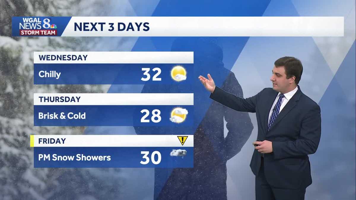
SURGERIES WILL CONTINUE TODAY AS SCHEDULED. NOW, THE WGAL NEWS EIGHT STORM TEAM FORECAST WITH METEOROLOGIST MIKE SUSKO. GOOD TUESDAY AFTERNOON. THE GOOD NEWS IS THAT WE’LL HAVE LESS INTENSE COLD THIS WEEK. YOU’RE STILL GOING TO BE BELOW AVERAGE, BUT IT WON’T BE AS NEARLY AS BAD AS WHAT WE HAD LAST WEEK. WE DO HAVE A CHANCE FOR SOME LIGHT SNOW POSSIBLE ON FRIDAY. DURING THE AFTERNOON AND EVENING COMMUTE. SO WE’LL BE TALKING A LITTLE BIT ABOUT THAT. AND UNFORTUNATELY, IF YOU DON’T LIKE THE COLD, FRIGID TEMPERATURES AND VERY LOW AND VERY COLD, WIND CHILLS RETURN AS WE HEAD INTO THE WEEKEND HERE, ESPECIALLY SATURDAY. BUT HERE’S A LOOK OUTSIDE LANCASTER RIGHT NOW. STILL GOT PLENTY OF SNOW ACROSS PARTS OF THE AREA, BUT THE SUN IS SHINING RIGHT NOW IN LANCASTER COUNTY. AND AS WE TAKE A LOOK HERE AT STORMTEAM RADAR NETWORK, IT’S A LITTLE BIT OF THAT CLEARING THERE OVER PARTS OF YORK AND LANCASTER COUNTY AT THE MOMENT. EVERYONE ELSE SEEING SOME CLOUD COVER, A FEW SNOW FLURRIES UP BY LEWISTOWN, AND THAT’S PRETTY MUCH ALL WE’RE GOING TO BE DEALING WITH AS WE GO THROUGH THE PARTS OF THE AFTERNOON. NOW, LATER ON THIS EVENING, YOU CAN SEE A LITTLE BIT OF THAT SNOW SHOWER ACTIVITY IN WEST VIRGINIA THAT WILL STAY MAINLY TO THE SOUTH. BUT IF YOU ARE SOUTH OF THE PENNSYLVANIA TURNPIKE, YOU MAY SEE A FEW MORE SNOW FLURRIES LATER ON THIS AFTERNOON AND EVENING HERE, BUT I DON’T THINK IT’S GOING TO ACCUMULATE MUCH. SO WHEN WE LOOK AT YOUR FORECAST HIGH OF 34 DEGREES, SO WE DO GET ABOVE FREEZING AS WE GO THROUGHOUT THE DAY TODAY, AND THEN TEMPERATURES WILL DROP BACK INTO THE 20S AND EVENTUALLY THE TEENS OVERNIGHT TONIGHT WITH A PARTLY CLOUDY SKY AND SOME GRADUAL CLEARING ACROSS THE AREA FOR YOUR WEDNESDAY. MOSTLY SUNNY, STILL CHILLY. WE’LL GET RIGHT AROUND 32 DEGREES THERE FOR THAT AFTERNOON HIGH, BUT WE’LL SEE A LOT OF SUNSHINE TOMORROW SO THAT WILL SHOULD HELP BRIGHTEN EVERYONE’S MOOD AS WE GO THROUGH THE DAY ON WEDNESDAY. HERE’S A LOOK AT PREDICTOR. WE HAVE THAT COLD FRONT COMING THROUGH AS WE GO THROUGH THE NIGHT. TONIGHT THERE’S AGAIN A COUPLE SNOW SHOWERS MAYBE FOR AREAS SOUTH OF THE PENNSYLVANIA TURNPIKE, BUT DOESN’T AMOUNT TO MUCH IF ANYTHING AT ALL. WEDNESDAY IS DRY, MOSTLY SUNNY THROUGHOUT THE DAY HERE. AND AS WE HEAD INTO YOUR THURSDAY LOOKS VERY SIMILAR. WE’RE GOING TO BE SEEING A MIX OF SUN AND CLOUDS ACROSS THE AREA AS HIGH PRESSURE COMES INTO CONTROL. FOR YOUR THURSDAY AFTERNOON. SO NEXT THREE DAYS JUST ENJOY THE THE NICER WEATHER, SO TO SPEAK. AS WE GO INTO WEDNESDAY AND THURSDAY. STILL BELOW AVERAGE BUT COULD BE A LOT WORSE. JUST LIKE WHAT WE HAD LAST WEEK. FRIDAY. WE DO HAVE THOSE AFTERNOON SNOW SHOWER CHANCES. IT IS AN IMPACT DAY BECAUSE OF THAT. AND WHEN WE LOOK AT THE SNOW FOR YOUR FRIDAY HERE AGAIN, IT’S MOSTLY FRIDAY, LATE AFTERNOON AND EVENING ACROSS THE AREA. THE MAIN CONCERN WITH THIS WOULD JUST BE SOME SNOW COVERED ROADS THAT WILL BE POSSIBLE, AND MAY LEAD TO SOME SLICK TRAVEL CONDITIONS. SO JUST SOMETHING TO KEEP IN MIND BEHIND IT. IN MY OPINION, THE MORE IMPACTFUL THING IS GOING TO BE THE COLD. HERE’S THE WIND CHILLS FOR SATURDAY MORNING. WELL BELOW ZERO. LIKELY GOING TO BE SEEING MORE COLD WEATHER ADVISORIES AS WE GO INTO SATURDAY MORNING. AND EVEN IN THE AFTERNOON. STILL FEELING LIKE IT’S BELOW ZERO ACROSS PARTS OF THE SUSQUEHANNA VALLEY. SO WE ARE GOING TO BE HAVING ANOTHER WEEKEND WITH THE INTENSE CHILL AS THE ARCTIC COLD RETURNS TO THE AREA. THAT WILL BE SATURDAY AND SUNDAY, AND WITH THE STRONG WINDS, IT’S NOT GOING TO BE REALLY LETTING UP THERE AS WELL. WE COULD SEE GUSTS WELL OVER 30MPH IN SOME CASES. SO THAT IS WHY YOU’RE SEEING SATURDAY AND SUNDAY, EVEN THOUGH LOTS OF SUNSHINE, IT’S GOING TO BE VERY COLD HERE BEHIND THAT SYSTEM. THAT BRINGS US A LITTLE BIT OF SNOW ON FRIDAY. SO A GOOD WEEKEND TO JUST STAY INSIDE AND MAYBE WATCH THE OLYMPICS OR THE SUPER BOWL THIS WEEKEND HERE. GOOD WEATHER FOR IT, AT LEAST IN OUR AREA. AND AS WE GO INTO NEXT WEEK, MONDAY AND TUESDAY IS LOOKING BRIGHTER AND SUNNIER, CHANCE FOR A LITTLE BIT MOR
Not As Cold Today; Light Snow Friday In South Central Pennsylvania
Isolated snow showers or flurries are possible

Updated: 12:32 PM EST Feb 3, 2026
Good afternoon,Look for mostly cloudy skies and light winds today. Highs will be milder than what we’ve seen lately, in the low-to-mid 30s.A quick-moving system will pass to our south this evening through tonight, leading to isolated snow showers or flurries, mainly along and south of the PA Turnpike from 6 p.m. until midnight. The chance is slim, but if you do see a snow shower, you could get a quick coating of snow.Clouds will gradually clear overnight, with lows falling to the upper teens.Wednesday will feature mostly sunny skies and highs near freezing. Winds will remain light, around 5-10 mph.Thursday will be brisk and cold. Highs will reach the upper 20s, but it will feel like the teens to low 20s, thanks to a 5-15 mph breeze.We’re watching a clipper, which could bring light snow across the area Friday afternoon and evening. Right now, snow totals look low, but a coating is possible on the roads, slowing travel.It will turn windy and much colder behind that system, leading to highs in the upper teens and low 20s, and lows in the single digits over the weekend. Gusty winds will push wind chills below zero Saturday and Sunday nights.Next week, temperatures gradually moderate to near freezing again on Tuesday. There’s a chance of a wintry mix on Wednesday, and possibly a mix to rain on Thursday.Have a great day!
Good afternoon,
Look for mostly cloudy skies and light winds today. Highs will be milder than what we’ve seen lately, in the low-to-mid 30s.
A quick-moving system will pass to our south this evening through tonight, leading to isolated snow showers or flurries, mainly along and south of the PA Turnpike from 6 p.m. until midnight. The chance is slim, but if you do see a snow shower, you could get a quick coating of snow.
Clouds will gradually clear overnight, with lows falling to the upper teens.
Wednesday will feature mostly sunny skies and highs near freezing. Winds will remain light, around 5-10 mph.
Thursday will be brisk and cold. Highs will reach the upper 20s, but it will feel like the teens to low 20s, thanks to a 5-15 mph breeze.
We’re watching a clipper, which could bring light snow across the area Friday afternoon and evening. Right now, snow totals look low, but a coating is possible on the roads, slowing travel.
It will turn windy and much colder behind that system, leading to highs in the upper teens and low 20s, and lows in the single digits over the weekend. Gusty winds will push wind chills below zero Saturday and Sunday nights.
Next week, temperatures gradually moderate to near freezing again on Tuesday. There’s a chance of a wintry mix on Wednesday, and possibly a mix to rain on Thursday.
Have a great day!