
After a reprieve yesterday, the Arctic air is back for the next two days. We are still tracking light snow for all of western Pennsylvania to close out the week. There will be three Impact Days in a row through the weekend.Colder stretch mid-weekLow temperatures drop back into the teens and single digits today and tomorrow. Fortunately, the wind will remain light, so the wind chill shouldn’t be much of a factor over these frigid starts. Meanwhile, daytime temperatures will only reach the low and mid 20s.We are waking up to lingering clouds and stray flurries. Sunshine will begin working back in later this morning. A mix of sun and clouds will continue this afternoon. Clouds will build back up during the day on Thursday ahead of a clipper set to arrive on Friday.Impact Day for light snow on FridayA clipper will bring more snow to western Pennsylvania on Friday. It is an Impact Day for the potential for 1-3 inches of snow. Snow showers will arrive from the northwest after the morning commute. The steadiest and most widespread snow will impact the afternoon and evening commute.Brief bitter blast for the weekendThe Impact Days will extend into the weekend with the return of much colder air. Highs return to the teens with single-digit lows. Despite the bitter cold, it will be a snow-free weekend. This cold blast is short-lived as highs finally break freezing early next week for the Pittsburgh area.TODAY: Quite cold, again, with gradual clearing. High: 24°.TONIGHT: Fair skies and frigid. Low: 6°.THURSDAY: Increasing clouds and still very cold. High: 23°, low: 12°.FRIDAY – Impact Day: Snow showers with light accumulations. High: 30°, low: 5°.SATURDAY – Impact Day: Cloudy skies and bitterly cold. High: 15°, low: 2°.
PITTSBURGH —
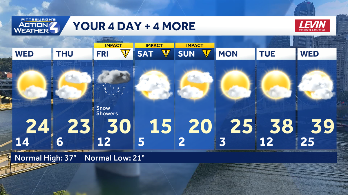
After a reprieve yesterday, the Arctic air is back for the next two days. We are still tracking light snow for all of western Pennsylvania to close out the week. There will be three Impact Days in a row through the weekend.
Colder stretch mid-week
Low temperatures drop back into the teens and single digits today and tomorrow. Fortunately, the wind will remain light, so the wind chill shouldn’t be much of a factor over these frigid starts. Meanwhile, daytime temperatures will only reach the low and mid 20s.

Hearst OwnedHearst
High temperatures slide back into the 20s around the Pittsburgh area.
We are waking up to lingering clouds and stray flurries. Sunshine will begin working back in later this morning. A mix of sun and clouds will continue this afternoon. Clouds will build back up during the day on Thursday ahead of a clipper set to arrive on Friday.
Impact Day for light snow on Friday
A clipper will bring more snow to western Pennsylvania on Friday. It is an Impact Day for the potential for 1-3 inches of snow. Snow showers will arrive from the northwest after the morning commute. The steadiest and most widespread snow will impact the afternoon and evening commute.

Hearst OwnedHearst
A clipper system will bring a few inches of snow to western PA on Friday.
Brief bitter blast for the weekend
The Impact Days will extend into the weekend with the return of much colder air. Highs return to the teens with single-digit lows. Despite the bitter cold, it will be a snow-free weekend. This cold blast is short-lived as highs finally break freezing early next week for the Pittsburgh area.

Hearst OwnedHearst
Pittsburgh’s run of sub-freezing temperatures will end early next week.
TODAY: Quite cold, again, with gradual clearing. High: 24°.
TONIGHT: Fair skies and frigid. Low: 6°.
THURSDAY: Increasing clouds and still very cold. High: 23°, low: 12°.
FRIDAY – Impact Day: Snow showers with light accumulations. High: 30°, low: 5°.
SATURDAY – Impact Day: Cloudy skies and bitterly cold. High: 15°, low: 2°.