
Western PA: Colder again, more light snow on Friday
Friday is the first of three Impact Days. Another bitter blast is in the works over the weekend.
YORK. 516 RIGHT NOW WE ARE DEALING WITH ANOTHER ROUND OF SOME COLD AIR. YOU’RE GOING TO NOTICE ABOUT 10 TO 15 DEGREES COLDER THAN WHAT YOU WOKE UP TO YESTERDAY MORNING. WE WILL HAVE SOME CLEARING SKIES ALREADY STARTING TO SEE SOME OF THOSE CLOUDS BREAK UP A LITTLE BIT. STAYING CHILLY ON THURSDAY. MOSTLY CLOUDY BY THE LATE MORNING AFTERNOON, THEN AN IMPACT DAY ON FRIDAY. WILL BE WATCHING ANOTHER ROUND OF SNOW SHOWERS. STICK AROUND. JUST ABOUT ONE MINUTE. I’LL BE TIMING OUT HOW MUCH YOU CAN EXPECT IN YOUR NEIGHBORHOOD RIGHT NOW IN PITTSBURGH, 17 FEELS LIKE IT IS FOR THOSE. WINDS ARE OUT OF THE NORTH NORTHWEST ABOUT 13MPH. BEAUTIFUL SKYLINE HERE OF OUR CITY, AND YOU CAN SEE THOSE CLOUDS AROUND. FEELS LIKE IT’S FOUR RIGHT NOW IN BUTLER, SIX IN NEW CASTLE, TEN IN WASHINGTON, 15 IN GREENSBURG AND NINE INTO INDIANA. SO OVERALL, IT IS A COLD START. WE’LL HAVE ANOTHER COLD DAY ON THURSDAY, WARMING UP NEAR 30 ON FRIDAY, BUT IT COMES WITH SOME SNOW SHOWERS RIGHT NOW. LOOKS TO BE LATE MORNING IN THE AFTERNOON, THEN ANOTHER BLAST OF SOME ARCTIC AIR. HIGHS ONLY REACHING NEAR 15 AS WE GET INTO SATURDAY, BUT CHECK THIS OUT NEXT TUESDAY AND WEDNESDAY. A LITTLE BIT OF IMPROVEMENT AS WE CLIMB ABOVE FREEZING AND INTO THE UPPER 30S. RIGHT NOW THOUGH, AGAIN, THINGS ARE RELATIVELY QUIET. WE HAVE THAT PESKY CLOUD COVER. STILL A FEW FLURRIES TRYING TO HANG ON, LINGERING, ESPECIALLY RIGHT NOW INTO WESTMORELAND AND FAYETTE COUNTY. BUT LET’S TIME OUT OUR FRIDAY. THIS IS 130 IN THE MORNING. MOSTLY CLOUDY SKIES RIGHT NOW. LOOKS GOOD FOR THE MORNING COMMUTE, SO THIS HAS SLOWED DOWN A LITTLE BIT FROM THE PAST COUPLE OF DAYS. BUT BY LATE MORNING AFTERNOON, WE’RE GOING TO START TO SEE THESE SNOW SHOWERS COMING. WE’RE NOT EXPECTING A LOT OF ACCUMULATION, BUT AGAIN, WE GET THAT FRESH COATING, THAT LIGHT DUSTING UP TO AN INCH AND THEN LOW VISIBILITY THAT COULD WREAK HAVOC AS WE GET INTO THE EVENING. AS KIDS ARE COMING HOME FROM SCHOOL, AS YOU’RE COMING HOME FROM WORK. SO IT COULD GET A LITTLE TRICKY, WE’LL SEE A LITTLE LULL IN THE ACTIVITY AROUND A LOT OF THE AREA AROUND SEVEN 8:00, BUT STILL EXPECTING MORE SNOW AS WE GET INTO EARLY SATURDAY BEFORE YOU WAKE UP. SO AS WE CONTINUE THROUGH FRIDAY BY 630, I THINK MOST OF US HAVE A QUICK INCH, INCH AND A HALF ON THE GROUND. THEN WE COULD SEE AN ADDITIONAL HALF AN INCH TO AN INCH. SO IN TOTAL, MOST OF US WILL SEE AROUND 1 TO 3IN HIGHER ELEVATIONS, ESPECIALLY IN SOMERSET AND GARRETT COUNTY COULD SEE A LITTLE BIT MORE. THERE’S YOUR FOUR DAY PLUS FOUR FORECAST. WE’LL GET THROUGH THE SNOW. THEN WE GOT THAT ARCTIC AIR THAT SETTLES IN FOR SATURDAY AND SUNDAY, MAKING BOTH DAYS IMPACT DAYS, SUNSHINE FOR MONDAY INTO THE MID 20S AND SLOWLY CLIMBING BACK UP. IT’S NICE TO SEE TEMPERATURES ABOVE T
Western PA: Colder again, more light snow on Friday
Friday is the first of three Impact Days. Another bitter blast is in the works over the weekend.

Updated: 4:43 AM EST Feb 4, 2026
After a reprieve yesterday, the Arctic air is back for the next two days. We are still tracking light snow for all of western Pennsylvania to close out the week. There will be three Impact Days in a row through the weekend.Colder stretch mid-weekLow temperatures drop back into the teens and single digits today and tomorrow. Fortunately, the wind will remain light, so the wind chill shouldn’t be much of a factor over these frigid starts. Meanwhile, daytime temperatures will only reach the low and mid 20s.We are waking up to lingering clouds and stray flurries. Sunshine will begin working back in later this morning. A mix of sun and clouds will continue this afternoon. Clouds will build back up during the day on Thursday ahead of a clipper set to arrive on Friday.Impact Day for light snow on FridayA clipper will bring more snow to western Pennsylvania on Friday. It is an Impact Day for the potential for 1-3 inches of snow. Snow showers will arrive from the northwest after the morning commute. The steadiest and most widespread snow will impact the afternoon and evening commute.Brief bitter blast for the weekendThe Impact Days will extend into the weekend with the return of much colder air. Highs return to the teens with single-digit lows. Despite the bitter cold, it will be a snow-free weekend. This cold blast is short-lived as highs finally break freezing early next week for the Pittsburgh area.TODAY: Quite cold, again, with gradual clearing. High: 24°.TONIGHT: Fair skies and frigid. Low: 6°.THURSDAY: Increasing clouds and still very cold. High: 23°, low: 12°.FRIDAY – Impact Day: Snow showers with light accumulations. High: 30°, low: 5°.SATURDAY – Impact Day: Cloudy skies and bitterly cold. High: 15°, low: 2°.
PITTSBURGH —
After a reprieve yesterday, the Arctic air is back for the next two days. We are still tracking light snow for all of western Pennsylvania to close out the week. There will be three Impact Days in a row through the weekend.
Colder stretch mid-week
Low temperatures drop back into the teens and single digits today and tomorrow. Fortunately, the wind will remain light, so the wind chill shouldn’t be much of a factor over these frigid starts. Meanwhile, daytime temperatures will only reach the low and mid 20s.

Hearst OwnedHearst
High temperatures slide back into the 20s around the Pittsburgh area.
We are waking up to lingering clouds and stray flurries. Sunshine will begin working back in later this morning. A mix of sun and clouds will continue this afternoon. Clouds will build back up during the day on Thursday ahead of a clipper set to arrive on Friday.
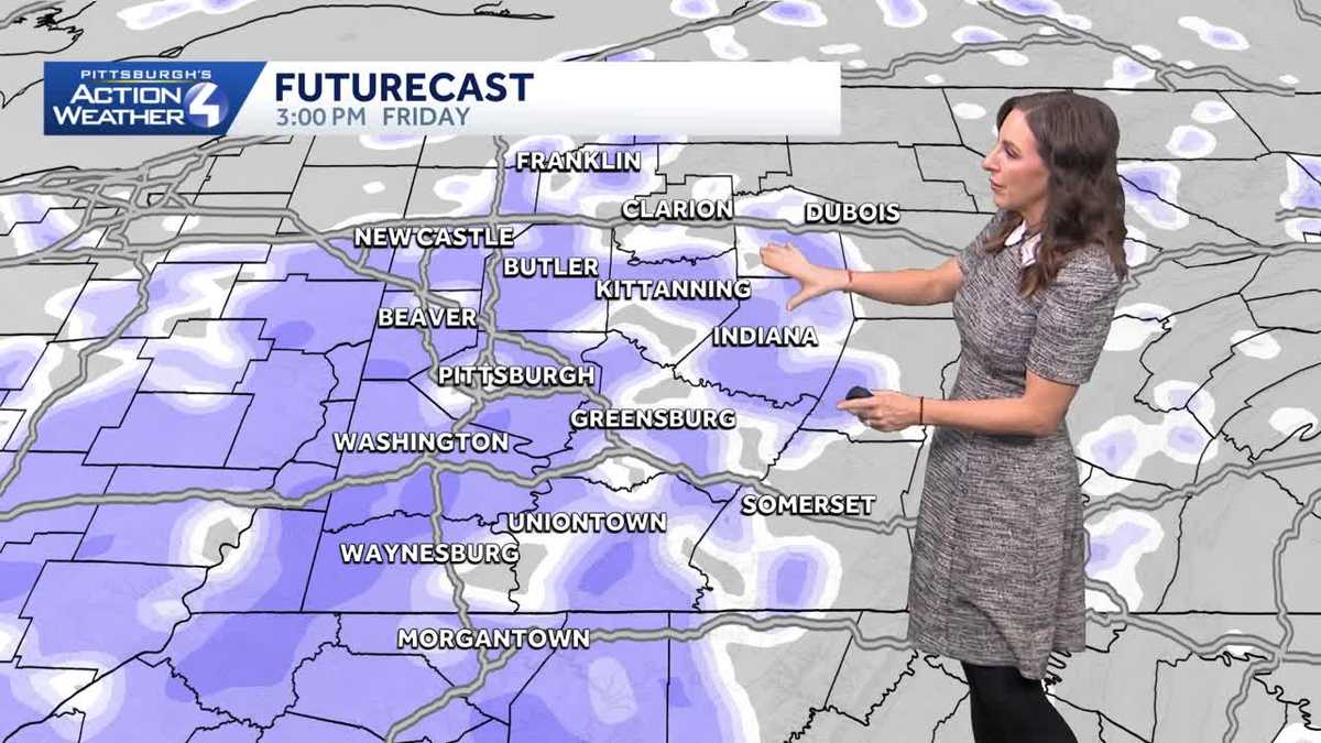
Impact Day for light snow on Friday
A clipper will bring more snow to western Pennsylvania on Friday. It is an Impact Day for the potential for 1-3 inches of snow. Snow showers will arrive from the northwest after the morning commute. The steadiest and most widespread snow will impact the afternoon and evening commute.

Hearst OwnedHearst
A clipper system will bring a few inches of snow to western PA on Friday.
Brief bitter blast for the weekend
The Impact Days will extend into the weekend with the return of much colder air. Highs return to the teens with single-digit lows. Despite the bitter cold, it will be a snow-free weekend. This cold blast is short-lived as highs finally break freezing early next week for the Pittsburgh area.

Hearst OwnedHearst
Pittsburgh’s run of sub-freezing temperatures will end early next week.
TODAY: Quite cold, again, with gradual clearing. High: 24°.
TONIGHT: Fair skies and frigid. Low: 6°.
THURSDAY: Increasing clouds and still very cold. High: 23°, low: 12°.
FRIDAY – Impact Day: Snow showers with light accumulations. High: 30°, low: 5°.
SATURDAY – Impact Day: Cloudy skies and bitterly cold. High: 15°, low: 2°.