
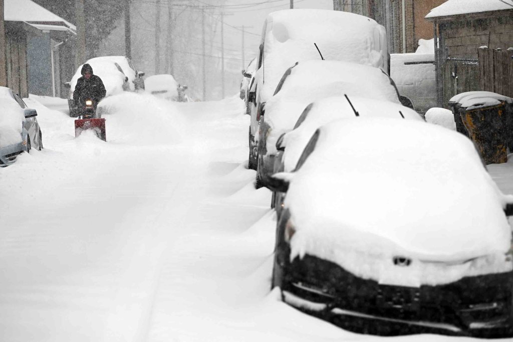
A lockdown snowfall followed by punishing cold at the end of January were the weather highlights of last month in Berks County, a storm whose evidence lingers more than 10 days later.
That 9.4-inch snowfall with sleet and freezing rain to seal the deal, figuratively and literally, has stuck around and expect it to stay a nuisance for weeks to come, if AccuWeather’s long-term forecast holds out.
“That storm brought the greatest accumulations since the blockbuster system of snow/sleet from Jan. 31 to Feb. 2, 2021, officially 18.6 inches for Reading,” said Jeffrey R. Stoudt, Berks weather historian and retired meteorologist. “The only winter storm accumulation of at least 6 inches since then … was 6.1 inches on Jan. 19, 2025.”
Last month was the 31st coldest January on record at an average temperature of 27.3 degrees at Reading Regional Airport, according to the National Weather Service, and coldest January since 2015, nosing out January 2025’s 27.5-degree average.
The 12 days that the temperature topped out no higher than the freezing mark was more than the long-term average of nine, and the most since 13 in January 2018. That month to start 2018 had more offsetting warmth, ending with a 28.6-degree average.
The most this century is 21 from 2004, a month that ended at an average of 23.2 degrees, 11th coldest in the 129-year Berks temperature database.
“The most (in the record period) was 29 during that legendary frigid January 1977,” Stoudt added.
He said that if the first half of January 2026 was as cold as the second half, it might have placed 10th coldest of 129, which remains 22.2 degrees from 1905. The most recent January among the 10 coldest is 1994 at 22 degrees.
As far as back-to-back Januaries, the coldest tandem is 1981 and 1982, at bone-chilling average temperatures of 21.9 and 20.8, respectively, with the latter the third coldest on record.
January 1977 is the coldest at 15.8 degrees and has never been challenged.
The cold period that was the 1970s through 1996 holds six of the 10 coldest Januaries, and many other monthly records.
The temperature fell to 32 degrees, the freezing point, at Reading Regional on Jan. 23 at 4:45 p.m. and didn’t get above freezing until 10:35 a.m. on Tuesday, Feb. 3. That’s about 10 days and 18 hours.
The weather service would round that up to 11 days, making the streak tied for 14th longest in the temperature database. It was longest since that bitter period from Dec. 26, 2017, through Jan. 8, 2018, which at 14 days is tied for fourth longest.
Here’s the top three from the Mount Holly, N.J., office of the weather service:
• 17 days: Jan. 12 through 28, 1977.
• 16 days: Jan. 19 through Feb. 2, 1961.
• 15 days: Dec. 15 through 29, 1989.
The 2017-18 string of 14 days is tied with five other streaks, including one other this century: Dec. 18 through Dec. 31, 2000.
Last month wasn’t all bad.
“Several days during the first half were rather mild, but none unusually so,” Stoudt added. “The month’s highest of 55 on the 8th is well below a typical January highest of around 60 and one of four days that warmed to at least 50.”
And there was a very pleasant day three days before the big storm, with sunny skies and a high in the upper 40s.
There was a rare subzero low temperature last month, a minus 1 on the 21st. It wasn’t a date record.
As far as snowfall goes, outside of a predawn snow squall on New Year’s Day that left a coating to an inch, measurable snow accumulations waited until the 17th, Stoudt said.
“Accumulations Saturday and Sunday the 17th and 18th fell mostly in the range of 5 to 9 inches, officially 6.8 inches,” he added.
By the major storm on the 25th, which was a date record, some of the week’s earlier snow was still on the ground.
“The snow-to-sleet boundary advanced northward to the Reading area or approximately to U.S. Route 422 rather quickly by midday then struggled to move farther north during the afternoon,” Stoudt said about the storm on the 25th.
“The accumulation was generally 8 to 10 inches Reading and southward but 11 to 15, perhaps an isolated 18, north of Reading.
“The rainfall equivalent was great enough to support 15 to 18 inches if only snow had fallen, which is what was observed farther north where the change to sleet was much delayed or did not occur.”
The official snow total for the month was 16.7 inches. The seasonal total of 20.4 inches is already more than the previous four winters. The 2020-21 season, with the big storm Jan. 31 to Feb. 2, finished at 42.8 inches.
Reliable rain and melted snow amounts, which were rather few, fell mostly between 2.5 and 3 inches and included 2.67 inches at Reading Regional, Stoudt said.
The AccuWeather long-range forecast shows nasty windy and frigid conditions arriving for the Friday-through-Monday period, and cold conditions continuing into next week, through not subfreezing all the time.
The forecast shows the mercury struggling to reach 40 on Feb. 13 and 14.
Berks January weather
• Temperature: 27.3 degrees
• Normal: 30.8
• Precipitation: 2.67 inches
• Normal: 2.97 inches
• Snowfall: 16.7 inches (season, 20.4)
• Records: None
• Ice days: 12 (season, 16) (temperature not higher than freezing)
Source: National Weather Service
Monthly snowfall totals from the Berks Area Rainfall Networks in inches:
• Shartlesville, 21.5
• Boyers Junction, 21.4
• Bernville, 19
• Dryville, 18.3
• Mohrsville, 18.1
• Hamburg, 18
• Lobachsville, 18
• Bechtelsville, 17.1
• Cacoosing, 17
• Cornwall Terrace, 16.8
• Lincoln Park, 16.7
• Wyomissing, 16.6
• Oley, 15.1
• Elverson NE, 15
• New Morgan, 14.3
• Quaker Hill, 13.5