
Clouds will gradually clear this morning, as low pressure passes to the south. Temperatures will fall to the low 20s. Look for mostly sunny skies and highs near freezing today. Winds will remain light, around 5-10 mph.Partly cloudy skies are in store tonight, with cold lows around 14 degrees. Thursday will be slightly colder, but we still get a good dose of sunshine. Highs will reach the upper 20s with a light breeze. We’re watching a clipper, which will bring light snow or snow showers across the area Friday afternoon and evening. Right now, snow totals look low, around a coating to 1″ through Friday night, but a coating on the roads will slow travel, so please use caution. Highs will reach 30 degrees, then fall to the teens overnight.It will turn gusty and much colder this weekend behind the clipper. Expect sub-zero wind chills early Saturday, and wind chills near zero Saturday afternoon. Winds could gust to 40 mph. It will be partly sunny, with highs reaching the upper teens. Temperatures will tumble to the single digits Saturday night, and wind chills will be below zero. Highs will reach 20 degrees Sunday, but wind chills will hover in the single digits to low teens under partly sunny skies.After another round of sub-zero chills Sunday night into early Monday, winds will diminish Monday afternoon. Highs will reach the mid-20s.Temperatures will gradually moderate to near freezing on Tuesday. There’s a chance of a wintry mix to rain on Wednesday, and possibly a mix to rain on Friday. Highs will reach the upper 30s at the end of the week.
Clouds will gradually clear this morning, as low pressure passes to the south. Temperatures will fall to the low 20s.
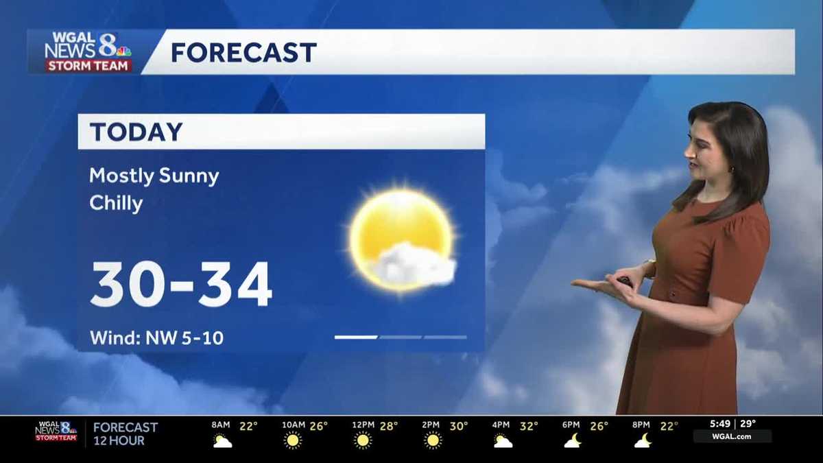
Look for mostly sunny skies and highs near freezing today. Winds will remain light, around 5-10 mph.
Partly cloudy skies are in store tonight, with cold lows around 14 degrees.
Thursday will be slightly colder, but we still get a good dose of sunshine. Highs will reach the upper 20s with a light breeze.
We’re watching a clipper, which will bring light snow or snow showers across the area Friday afternoon and evening. Right now, snow totals look low, around a coating to 1″ through Friday night, but a coating on the roads will slow travel, so please use caution. Highs will reach 30 degrees, then fall to the teens overnight.
It will turn gusty and much colder this weekend behind the clipper. Expect sub-zero wind chills early Saturday, and wind chills near zero Saturday afternoon. Winds could gust to 40 mph. It will be partly sunny, with highs reaching the upper teens.
Temperatures will tumble to the single digits Saturday night, and wind chills will be below zero.
Highs will reach 20 degrees Sunday, but wind chills will hover in the single digits to low teens under partly sunny skies.
After another round of sub-zero chills Sunday night into early Monday, winds will diminish Monday afternoon. Highs will reach the mid-20s.
Temperatures will gradually moderate to near freezing on Tuesday. There’s a chance of a wintry mix to rain on Wednesday, and possibly a mix to rain on Friday. Highs will reach the upper 30s at the end of the week.