
WGAL NEWS EIGHT. GOOD AFTERNOON. HOT OFF THE PRESS AND MORE LIKE COLD OFF THE PRESS HERE FOR THE SUSQUEHANNA VALLEY IS AN EXTREME COLD WATCH IS NOW GOING TO BE GOING INTO EFFECT AT 4 A.M. ON SATURDAY THROUGH 10 A.M. ON SUNDAY. THAT JUST CAME DOWN FROM THE NATIONAL WEATHER SERVICE ABOUT A MINUTE AGO. AND THIS IS FOR EVERYONE HERE NOW IN EXTREME COLD CRITERIA FOR THE NATIONAL WEATHER SERVICE IN OUR AREA IS A WIND CHILL OF -20 OR BELOW FOR ALL THE SUSQUEHANNA VALLEY. NOW, IF YOU’RE IN CHESTER COUNTY, IT CHANGES A LITTLE BIT. IT’S ACTUALLY MINUS TEN OR LOWER FOR YOU AS YOU HEAD TOWARDS PHILADELPHIA, BUT NONETHELESS IT IS. WE ARE EXPECTING EXTREME COLD ACROSS THE AREA HERE AS WE GO INTO ESPECIALLY SATURDAY. SO THAT’S WHEN WE EXPECT THE COLDEST WEATHER TO BE ACROSS THE AREA. SUNDAY GETS A LITTLE BIT BETTER WITH IMPROVEMENT AND THEN EVEN MORE SO ON MONDAY. BUT WE WANT TO MAKE SURE THAT YOU ARE AWA
Extreme cold watch issued to all of south-central Pennsylvania

Updated: 12:39 PM EST Feb 5, 2026
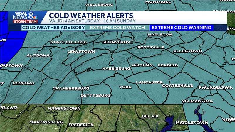
The National Weather Service issued an extreme cold watch to all of south-central Pennsylvania. The watch will go into effect for the entire Susquehanna Valley from late Friday night through Sunday morning. The NWS warns that dangerously cold wind chills could drop as low as 20 degrees below zero. This could result in hypothermia or frostbite if precautions are not taken, according to the NWS. Residents are advised to dress warm and cover exposed skin if outdoors. Friday Timing: Light snow showers late afternoon through the night.Totals: Coating to an inch for most; some spots may see no snow.Temperatures: High near 30; falling to the teens overnight.Impacts: Slick/snow-covered roads could slow the evening commute and make travel hazardous. SaturdayWindy: Sustained 20 to 30 mph winds with gusts up to 45 mph; wind chills -10 to -19 Saturday morning and -5 to -15 during the day.Temperatures/Sky: Partly sunny with temperatures in the teens with single digits in the afternoon. Impacts: Scattered power outages possible; blowing branches and debris. SundayWind chills: Below zero Sunday morning, improving to single digits to low teens during the day; winds not as strong as Saturday. Temperatures: Partly sunny with highs around 20 degrees. SOUTH-CENTRAL PA WEATHER RESOURCES: INTERACTIVE RADAR | ACTIVE WEATHER ALERTS | CURRENT CONDITIONS | HOURLY FORECAST | 10-DAY FORECAST | WEEKEND FORECAST | MAP ROOM | DOWNLOAD THE APP | WEATHER EMAILS
The National Weather Service issued an extreme cold watch to all of south-central Pennsylvania.
The watch will go into effect for the entire Susquehanna Valley from late Friday night through Sunday morning.
The NWS warns that dangerously cold wind chills could drop as low as 20 degrees below zero.
This could result in hypothermia or frostbite if precautions are not taken, according to the NWS. Residents are advised to dress warm and cover exposed skin if outdoors.

Friday
Timing: Light snow showers late afternoon through the night.Totals: Coating to an inch for most; some spots may see no snow.Temperatures: High near 30; falling to the teens overnight.Impacts: Slick/snow-covered roads could slow the evening commute and make travel hazardous.
SaturdayWindy: Sustained 20 to 30 mph winds with gusts up to 45 mph; wind chills -10 to -19 Saturday morning and -5 to -15 during the day.Temperatures/Sky: Partly sunny with temperatures in the teens with single digits in the afternoon. Impacts: Scattered power outages possible; blowing branches and debris.


SundayWind chills: Below zero Sunday morning, improving to single digits to low teens during the day; winds not as strong as Saturday. Temperatures: Partly sunny with highs around 20 degrees.

SOUTH-CENTRAL PA WEATHER RESOURCES: INTERACTIVE RADAR | ACTIVE WEATHER ALERTS | CURRENT CONDITIONS | HOURLY FORECAST | 10-DAY FORECAST | WEEKEND FORECAST | MAP ROOM | DOWNLOAD THE APP | WEATHER EMAILS