
Scattered snow showers will develop on Friday in south-central Pennsylvania, followed by brutally cold winds into the weekend. The WGAL News 8 Storm Team has declared Friday and Sunday as Impact Days, meaning the weather will likely disrupt your normal daily schedule or routine.Saturday has been upgraded as an Alert Day, meaning the day features the threat of extreme, severe and possibly life-threatening weather. Snow showers FridayTiming: A clipper will bring light snow showers Friday afternoon through Friday night. Totals: Most areas will see a coating to an inch. However, some spots may see no snow at all. Temperatures: Highs will reach 30 degrees, then fall to the teens overnight. Impacts: Snow-covered roads could create hazardous conditions, slow travel during the evening commute and slick roads. Brutal winds SaturdayBone-chilling winds: Sustained winds will range from 25-35 mph, with gusts between 40-50 mph. Morning wind chills will range from -10 to -20, and chills during the day will range from -5 to -15. Temperatures: It will be partly sunny with temperatures in the teens and single digits in the afternoon. Impacts: The strong, blustery winds could cause scattered power outages and blow around branches and debris.Precautions: Frostbite is possible with prolonged outdoor exposure overnight and early in the morning. Dress warm and cover exposed skin when outside.Winds linger SundayWind chills: Bitter winds remain, but they won’t be as strong as Saturday. Wind chill values will be below zero in the morning, then single digits to low teens during the day. Temperatures: Highs will reach 20 degrees under partly sunny skies. SOUTH-CENTRAL PA WEATHER RESOURCES: INTERACTIVE RADAR | ACTIVE WEATHER ALERTS | CURRENT CONDITIONS | HOURLY FORECAST | 10-DAY FORECAST | WEEKEND FORECAST | MAP ROOM | DOWNLOAD THE APP | WEATHER EMAILS
Scattered snow showers will develop on Friday in south-central Pennsylvania, followed by brutally cold winds into the weekend.
The WGAL News 8 Storm Team has declared Friday and Sunday as Impact Days, meaning the weather will likely disrupt your normal daily schedule or routine.
Saturday has been upgraded as an Alert Day, meaning the day features the threat of extreme, severe and possibly life-threatening weather.


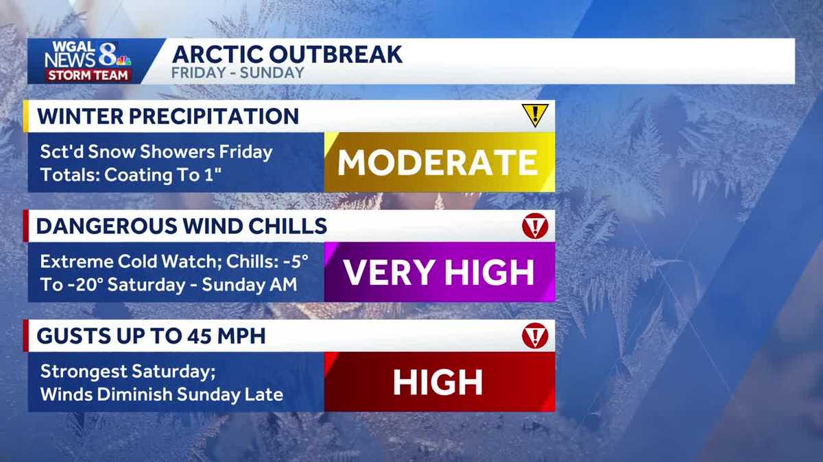
Snow showers Friday
Timing: A clipper will bring light snow showers Friday afternoon through Friday night.
Totals: Most areas will see a coating to an inch. However, some spots may see no snow at all.
Temperatures: Highs will reach 30 degrees, then fall to the teens overnight.
Impacts: Snow-covered roads could create hazardous conditions, slow travel during the evening commute and slick roads.


Brutal winds Saturday
Bone-chilling winds: Sustained winds will range from 25-35 mph, with gusts between 40-50 mph. Morning wind chills will range from -10 to -20, and chills during the day will range from -5 to -15.
Temperatures: It will be partly sunny with temperatures in the teens and single digits in the afternoon.
Impacts: The strong, blustery winds could cause scattered power outages and blow around branches and debris.
Precautions: Frostbite is possible with prolonged outdoor exposure overnight and early in the morning. Dress warm and cover exposed skin when outside.


Winds linger Sunday
Wind chills: Bitter winds remain, but they won’t be as strong as Saturday. Wind chill values will be below zero in the morning, then single digits to low teens during the day.
Temperatures: Highs will reach 20 degrees under partly sunny skies.

SOUTH-CENTRAL PA WEATHER RESOURCES: INTERACTIVE RADAR | ACTIVE WEATHER ALERTS | CURRENT CONDITIONS | HOURLY FORECAST | 10-DAY FORECAST | WEEKEND FORECAST | MAP ROOM | DOWNLOAD THE APP | WEATHER EMAILS