
We are tracking light snow for all of western Pennsylvania to close out the week.There will be three Impact Days in a row through the weekend.Impact Day for light snow on FridayA clipper will bring more snow to western Pennsylvania on Friday. It is an Impact Day for the potential for 1 to 3 inches of snow during the day.Snow showers will arrive from the northwest after the morning commute. The steadiest and most widespread snow will be around lunchtime.There will be a break Friday evening. As the wind picks up, bands of snow will develop Friday night. Snow squalls with an additional half an inch to an inch of snow are possible. The higher elevations east could end up with a fresh 2-5 inches by Saturday morning.A Winter Weather Advisory is in effect between 10 a.m. Friday and early Saturday morning for possible heavy snow for the Laurel Highlands. The higher terrain of Fayette, Indiana, and Westmoreland counties along with eastern Monongalia, Preston, and Garrett counties. More than three inches of snow plus gusty winds will create difficult travel conditions, especially Friday evening.Bitter blast for the weekendThe Impact Days will extend into the weekend with the return of much colder air.High temperatures return to the teens with single-digit lows. Saturday will be especially cold with 25-30 mph gusts placing our wind chills well below zero. Despite the bitter cold, it will be a snow-free weekend.This cold blast is short-lived as high temperatures finally break freezing early next week for the Pittsburgh area.We are watching for the return of rain by the middle to end of next week.OVERNIGHT: Cloudy. Low 14°FRIDAY – Impact Day: Snow showers with light accumulations. High: 30°, low: 4°.SATURDAY – Impact Day: Cloudy skies and bitterly cold. High: 12°, low: -2°. Subzero wind chills through the day.SUNDAY – Impact Day: Partly cloudy. High of 18°, low: 5°.
PITTSBURGH —
We are tracking light snow for all of western Pennsylvania to close out the week.
There will be three Impact Days in a row through the weekend.
Impact Day for light snow on Friday
A clipper will bring more snow to western Pennsylvania on Friday. It is an Impact Day for the potential for 1 to 3 inches of snow during the day.
Snow showers will arrive from the northwest after the morning commute. The steadiest and most widespread snow will be around lunchtime.

There will be a break Friday evening. As the wind picks up, bands of snow will develop Friday night. Snow squalls with an additional half an inch to an inch of snow are possible. The higher elevations east could end up with a fresh 2-5 inches by Saturday morning.
A Winter Weather Advisory is in effect between 10 a.m. Friday and early Saturday morning for possible heavy snow for the Laurel Highlands. The higher terrain of Fayette, Indiana, and Westmoreland counties along with eastern Monongalia, Preston, and Garrett counties. More than three inches of snow plus gusty winds will create difficult travel conditions, especially Friday evening.

Hearst Owned
Winter Weather Advisory for the Laurel Highlands from Friday morning to Saturday morning.
Bitter blast for the weekend

Hearst Owned
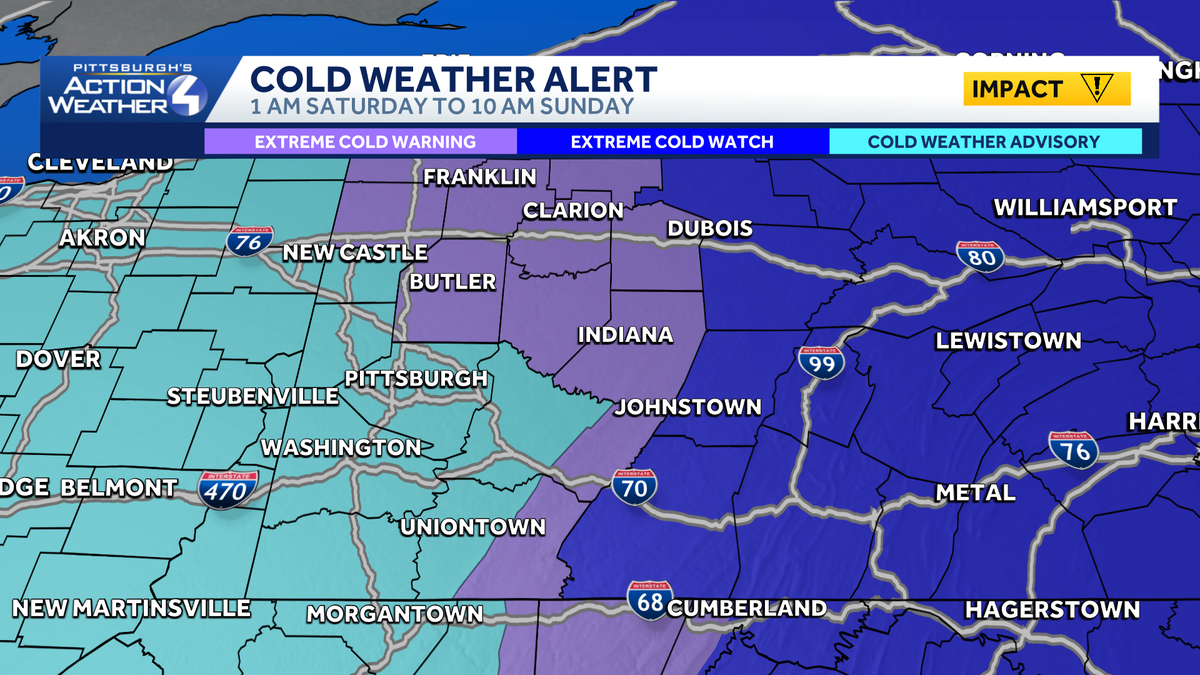
Extreme Cold Warning north and east of Pittsburgh. Cold Weather Advisory for everyone else Saturday into Sunday.
The Impact Days will extend into the weekend with the return of much colder air.
High temperatures return to the teens with single-digit lows. Saturday will be especially cold with 25-30 mph gusts placing our wind chills well below zero. Despite the bitter cold, it will be a snow-free weekend.
This cold blast is short-lived as high temperatures finally break freezing early next week for the Pittsburgh area.
We are watching for the return of rain by the middle to end of next week.

Hearst Owned
Snow for Friday then another arctic blast. Temperatures get above average next week.
OVERNIGHT: Cloudy. Low 14°
FRIDAY – Impact Day: Snow showers with light accumulations. High: 30°, low: 4°.
SATURDAY – Impact Day: Cloudy skies and bitterly cold. High: 12°, low: -2°. Subzero wind chills through the day.
SUNDAY – Impact Day: Partly cloudy. High of 18°, low: 5°.