
Brutally cold air is pushing into Western Pennsylvania this weekend, with both an extreme cold warning and a cold weather advisory in place for counties. Friday, light snow returns with a chance to see between 1 to 3 inches. Impact Day: Light Snow ReturnsA clipper from the NW brings another round of light snow today. It is an Impact Day for the potential for 1 to 3 inches of snow during the day.Snow arrives this morning but still looks like most of the widespread, low visibility will hit late morning, after 10am, and into the afternoon. A break in some spots late afternoon but another wave of snow comes in for the late evening.There will be a break Friday evening. As the wind picks up, bands of snow will develop Friday night. Snow squalls with an additional half an inch to an inch of snow are possible. The higher elevations east could end up with a fresh 2-5 inches by Saturday morning.A Winter Weather Advisory is in effect between 10 a.m. Friday and early Saturday morning for possible heavy snow for the Laurel Highlands. The higher terrain of Fayette, Indiana, and Westmoreland counties along with eastern Monongalia, Preston, and Garrett counties. More than three inches of snow plus gusty winds will create difficult travel conditions, especially Friday evening.Bitter blast for the weekendThe Impact Days will extend into the weekend with the return of much colder air.High temperatures return to the teens with single-digit lows. Saturday will be especially cold with 25-30 mph gusts placing our wind chills well below zero. Despite the bitter cold, it will be a snow-free weekend.Warnings and AdvisoriesExtreme cold warning and a cold weather advisory are in place for the region starting Saturday at 1 a.m. until 7 a.m. Sunday.This cold blast is short-lived as high temperatures finally break freezing early next week for the Pittsburgh area.We are watching for the return of rain by the middle to end of next week.TODAY – Impact Day: Snow showers, 1-3″ of accumulation. High: 30°, low: 4°.SATURDAY – Impact Day: Cloudy skies,sct’d flurries and bitterly cold. High: 12°, low: -2°. Subzero wind chills through the day.SUNDAY – Impact Day: Partly cloudy. High of 18°, low: 5°.
PITTSBURGH —
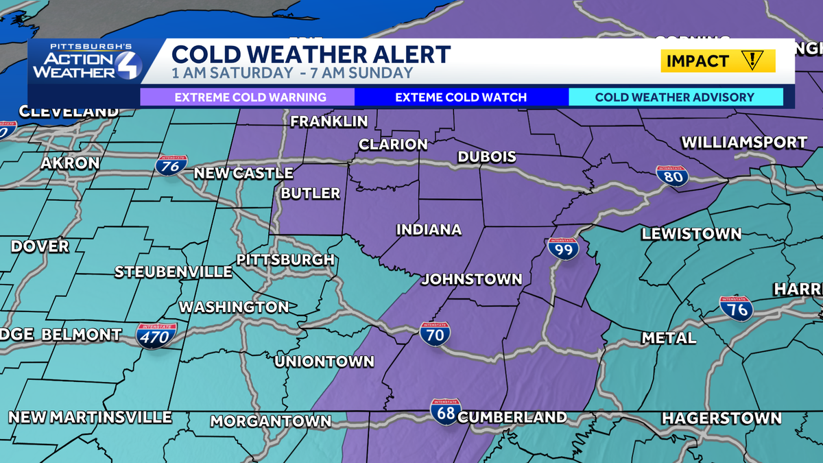
Brutally cold air is pushing into Western Pennsylvania this weekend, with both an extreme cold warning and a cold weather advisory in place for counties.
Friday, light snow returns with a chance to see between 1 to 3 inches.
Impact Day: Light Snow Returns
A clipper from the NW brings another round of light snow today. It is an Impact Day for the potential for 1 to 3 inches of snow during the day.
Snow arrives this morning but still looks like most of the widespread, low visibility will hit late morning, after 10am, and into the afternoon. A break in some spots late afternoon but another wave of snow comes in for the late evening.

There will be a break Friday evening. As the wind picks up, bands of snow will develop Friday night. Snow squalls with an additional half an inch to an inch of snow are possible. The higher elevations east could end up with a fresh 2-5 inches by Saturday morning.
A Winter Weather Advisory is in effect between 10 a.m. Friday and early Saturday morning for possible heavy snow for the Laurel Highlands. The higher terrain of Fayette, Indiana, and Westmoreland counties along with eastern Monongalia, Preston, and Garrett counties. More than three inches of snow plus gusty winds will create difficult travel conditions, especially Friday evening.

Bitter blast for the weekend

The Impact Days will extend into the weekend with the return of much colder air.
High temperatures return to the teens with single-digit lows. Saturday will be especially cold with 25-30 mph gusts placing our wind chills well below zero. Despite the bitter cold, it will be a snow-free weekend.
Warnings and Advisories
Extreme cold warning and a cold weather advisory are in place for the region starting Saturday at 1 a.m. until 7 a.m. Sunday.

This cold blast is short-lived as high temperatures finally break freezing early next week for the Pittsburgh area.
We are watching for the return of rain by the middle to end of next week.
TODAY – Impact Day: Snow showers, 1-3″ of accumulation. High: 30°, low: 4°.
SATURDAY – Impact Day: Cloudy skies,sct’d flurries and bitterly cold. High: 12°, low: -2°. Subzero wind chills through the day.
SUNDAY – Impact Day: Partly cloudy. High of 18°, low: 5°.