
Sub-zero wind chills, winds slowly ease, then single digit feels like temps for South-Central Pennsylvania
Wind chills as low as -20° possible early this morning. As the wind slowly diminishes, wind chills rise to the single digits for the afternoon and evening.
TEAM FORECAST WITH METEOROLOGIST MARYELLEN PANN. WE’RE STILL GOING TO BE DEALING WITH SOME GUSTY WINDS TODAY. ALTHOUGH NOT AS STRONG AS YESTERDAY. WE HAD WINDS GUSTING 50 TO 55MPH. THOSE WERE THE HIGHEST WIND GUSTS I COULD FIND TODAY. MORE LIKE 25 TO 30. BUT ENOUGH TO STILL HAVE AN IMPACT ON HOW IT FEELS OUTSIDE, ESPECIALLY THIS MORNING. WE’RE STILL GOING TO BE DEALING WITH SUBZERO WIND CHILLS. THEY’LL HEAD TO THE SINGLE DIGITS FOR THE AFTERNOON AS THE WINDS DIMINISH. SO IT IS AN IMPACT DAY BECAUSE OF THOSE COLD WIND CHILL READINGS. MILDER TEMPERATURES DO HEAD OUR WAY AS WE HEAD INTO THE TEN DAY FORECAST. FURTHER INTO THE TEN DAY, I SHOULD SAY, AND WE ARE WATCHING A COUPLE SYSTEMS THAT COULD BRING US A LITTLE WINTRY MIX, MAYBE A LITTLE RAIN, A LITTLE SNOW. I’LL HIGHLIGHT THOSE HERE COMING UP IN JUST A LITTLE BIT. TEMPERATURE AND WIND CHILL TOGETHER. YEAH. HIGHS ARE ONLY GOING TO MAKE IT INTO THE UPPER TEENS THIS MORNING. WE’RE IN THE SINGLE DIGITS WITH THE WINDS. IT FEELS LIKE ALMOST TEN BELOW ZERO. AND AT TIMES I’VE SEEN THOSE NUMBERS EVEN COLDER. ONCE WE GET PAST I WOULD SAY LUNCHTIME. WE SEE THOSE NUMBERS HEADING INTO THE SINGLE DIGITS. SO A SLIGHT IMPROVEMENT UNTIL WE HEAD INTO THE EVENING AND OVERNIGHT PERIOD WINDS WILL STILL GUST. AS I MENTIONED, 25 TO 30MPH. BUT AS WE HEAD THROUGH THE EVENING HOURS, THEY REALLY START TO EASE UP, ESPECIALLY OVERNIGHT. BUT EVEN WITH A 5 TO 10 MILE PER HOUR BREEZE, THAT’S STILL GOING TO HAVE AN IMPACT ON HOW IT FEELS OUTSIDE OVERNIGHT TONIGHT INTO TOMORROW MORNING. PLENTY OF SUNSHINE EXPECTED TODAY, SO AT LEAST WE HAVE THAT GOING FOR US. BUT AGAIN, YOU’RE STILL GOING TO WANT TO BUNDLE UP, ESPECIALLY THIS MORNING WITH THOSE DANGEROUS WIND CHILLS STILL EXPECTED NOW OVERNIGHT TONIGHT WITH MOSTLY CLEAR SKIES. WE’VE GOT TEMPERATURES DROPPING INTO THE SINGLE DIGITS ONCE AGAIN. AND WITH THAT 5 TO 10 MILE PER HOUR BREEZE, IT’S GOING TO FEEL ANYWHERE FROM 0 TO 10 BELOW TOMORROW MORNING. SO ANOTHER FRIGID START TO THE DAY. WE DO HEAD INTO THE 20S TOMORROW. WE’RE TALKING MID TO UPPER 20S AND YOU CAN SEE WE’LL HAVE A INCREASING CLOUDS, A LITTLE MORE CLOUD COVER DURING THE AFTERNOON. WINDS, THOUGH MUCH, MUCH LIGHTER. ONLY ABOUT FIVE MILES PER HOUR. RIGHT NOW WE HAVE TEMPERATURES SITTING AT SEVEN IN LEBANON, FIVE IN LANCASTER AND LEWISTOWN, NINE IN CARLISLE AND YORK. WE’VE GOT 12 IN CHAMBERSBURG. WINDS ARE ANYWHERE FROM THREE IN SELINSGROVE, 20 IN CHAMBERSBURG, NINE IN LANCASTER. ENOUGH TO HAVE AN IMPACT. IT FEELS LIKE NINE BELOW IN LANCASTER AND CARLISLE, 12 BELOW IN LEWISTOWN, SIX BELOW IN CHAMBERSBURG. WE DO HAVE MOSTLY CLEAR SKIES AS WE CHECK OUT OUR STORM TEAM LIVE RADAR NETWORK. IT’S QUIET. IT’S GOING TO STAY QUIET TODAY AND EVEN INTO TOMORROW THANKS TO HIGH PRESSURE. IT’S THAT HIGH PRESSURE SYSTEM THAT’S GOING TO GET RID OF THESE BLUSTERY CONDITIONS AS IT BUILDS CLOSER THROUGHOUT THE DAY TODAY AND INTO THE EVENING HOURS. JUST SOME PASSING CLOUDS, BUT PLENTY OF SUNSHINE CLEAR TONIGHT. WE START OFF WITH SUNSHINE TOMORROW AND THEN THE CLOUDS WILL BUILD IN THROUGH THE AFTERNOON HOURS MIXED WITH THAT SUNSHINE AND THE HIGH PRESSURE SYSTEM MOVES TO THE SOUTH. SO WHAT THAT DOES IS BRINGS OUR WINDS IN FROM THE SOUTH SOUTHEAST. THAT’S GOING TO HELP TO MODERATE TEMPERATURES A LITTLE BIT, BUT IT DOES PRODUCE CLOUDS. FOR TUESDAY. WE GET INTO THE WARMER SECTOR HERE. COLD FRONT WILL COME THROUGH. IT LOOKS LIKE EARLY WEDNESDAY MORNING. BUT NOTICE NOT A LOT OF PRECIPITATION. WE THOUGHT WE WOULD GET SOMETHING OUT OF THIS. AT MOST WE MAY GET SOME FLURRIES OVERNIGHT INTO EARLY WEDNESDAY MORNING. WE HAVE HAD A STREAK OF 16 DAYS OF MORNING LOWS, NOT EVEN TOUCHING 20 DEGREES. THAT’S TIED FOR ACTUALLY IT’S IN THE TOP FOUR IN TERMS OF COLDEST STRETCHES. WE’VE GOT THREE MORE DAYS THIS MORNING, TOMORROW AND TUESDAY WITH TEMPERATURES BELOW 20, WE FINALLY GET ABOVE AVERAGE FOR MORNING LOWS BY WEDNESDAY, AND WE’LL STAY CLOSE TO THAT AS WE HEAD THROUGH THE TEN DAY. BUT AFTERNOON READINGS, THEY’LL HEAD ABOVE FREEZING. FINALLY, ON TUESDAY, WE GET CLOSE TO 40. ON WEDNESDAY. SOME AREAS MAY TOUCH 40 DEGREES. THE AVERAGE IS 40. BY THE END OF THE WEEK, IT’S 42 AND WE WE DROP BACK BELOW AVERAGE TOWARDS THE END OF THE WEEK. NOW THE SYSTEM WE’RE WATCHING IS SATURDAY INTO SUNDAY FOR THE PRESIDENTS DAY WEEKEND RIGHT NOW. STILL HAVE THAT CHANCE FOR RAIN AND OR SNOW SHOWERS.
Sub-zero wind chills, winds slowly ease, then single digit feels like temps for South-Central Pennsylvania
Wind chills as low as -20° possible early this morning. As the wind slowly diminishes, wind chills rise to the single digits for the afternoon and evening.

Updated: 6:33 AM EST Feb 8, 2026
Extreme Cold Warning in effect for all counties until 10 a.m. Wind chills could be as cold as -20. As the winds slowly diminish, the feel like temperatures improve to the single digits during the afternoon. IMPACT DAY SUNDAY: FOR SINGLE DIGIT WIND CHILLSHeading into the afternoon, under mostly sunny skies, highs reach the mid to upper teens. While the winds are not nearly as strong as Saturday, they will be out of the northwest 10 to 20 mph, with gusts 25 to 30 mph, producing wind chills in the single digits. The winds lighten up during the late evening. Tonight, under mostly clear skies, lows drop to the single digits. With a of breeze 5 to 10 mph, it’s another round of sub-zero chills tonight into early Monday. Temperatures will gradually moderate to 36 degrees on Tuesday under a mix of clouds and sunshine.Other than a few flurries, Wednesday is dry with mostly cloudy skies. Highs are in the upper 30s. Thursday and Friday, the breeze picks up and temperatures trend a little colder again. Highs will reach the low 30s, but it will feel like the 20s.We are watching the chance for a winter storm over the Presidents Day weekend. Right now, signals suggest a developing system, but chances, timing, and confidence in a developing storm are still low currently. We’ll update as we go through next week.Stay warm!
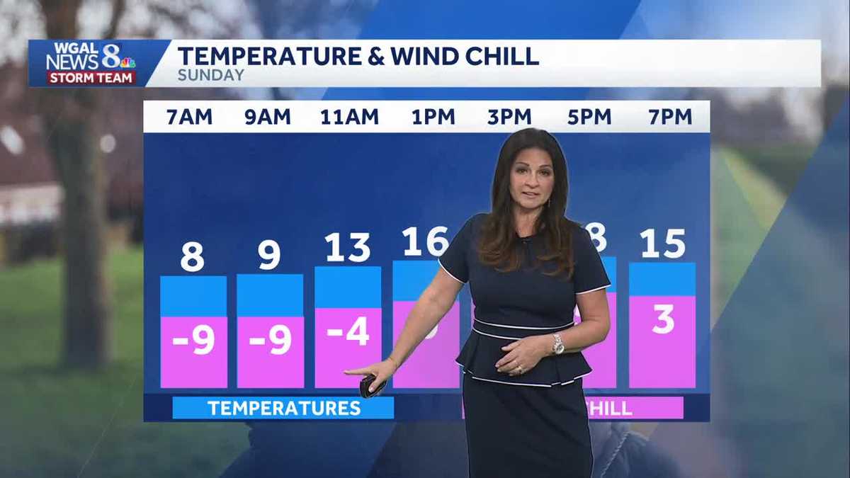
Extreme Cold Warning in effect for all counties until 10 a.m. Wind chills could be as cold as -20. As the winds slowly diminish, the feel like temperatures improve to the single digits during the afternoon.
IMPACT DAY SUNDAY: FOR SINGLE DIGIT WIND CHILLS
Heading into the afternoon, under mostly sunny skies, highs reach the mid to upper teens. While the winds are not nearly as strong as Saturday, they will be out of the northwest 10 to 20 mph, with gusts 25 to 30 mph, producing wind chills in the single digits. The winds lighten up during the late evening.
Tonight, under mostly clear skies, lows drop to the single digits. With a of breeze 5 to 10 mph, it’s another round of sub-zero chills tonight into early Monday.
Temperatures will gradually moderate to 36 degrees on Tuesday under a mix of clouds and sunshine.
Other than a few flurries, Wednesday is dry with mostly cloudy skies. Highs are in the upper 30s. Thursday and Friday, the breeze picks up and temperatures trend a little colder again. Highs will reach the low 30s, but it will feel like the 20s.
We are watching the chance for a winter storm over the Presidents Day weekend. Right now, signals suggest a developing system, but chances, timing, and confidence in a developing storm are still low currently. We’ll update as we go through next week.
Stay warm!