
IMPACT: Sub-zero chills on tap once again for south-central Pennsylvania
Another Cold Weather Advisory will be in effect tonight. Wind chills could drop as low as -15° overnight! Monday will start mostly sunny skies along with kicking off the moderating temperature trend into next weekend. We’re watching for a chance of wintry weather heading into President’s Day weekend, which we’ll continue to monitor.
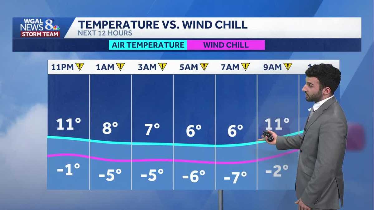
FLY EAGLES FLY ALL THE WAY. JERRY, LAURA, SEND IT BACK TO YOU GUYS. A COUPLE TIMES. SEAN SAID THE EAGLES, YOU KNOW. YEAH. MAYBE NEXT TIME. YEAH. OF COURSE YOU KNOW. AND SO IT HAS BEEN SUCH A COLD WEEKEND WEATHER YESTERDAY OR TODAY RYAN TO GO OUT AND DO MUCH OF ANYTHING, WHETHER IT’S WATCHING CIVIL WAR OR ANYTHING ELSE. YEAH I KNOW AND I REALLY WISH I COULD HAVE BROUGHT THE WARMER WEATHER FOR EVERYBODY. ALTHOUGH IT’S FEELING VERY COLD OUT THERE. SINGLE DIGITS AS YOU SAW EARLIER. ALSO, SUBZERO FEELS LIKE TEMPERATURES ARE GOING TO BE ON TAP FOR US FOR TONIGHT, DESPITE EVEN THE LIGHTER WINDS AS WE GET INTO THE OVERNIGHT PERIOD. NOW, I WILL SAY A MILDER WEEK IS AHEAD. I’LL SHOW YOU THAT IN THE FULL TEN DAY FORECAST IN A COUPLE MINUTES HERE. BUT WE ARE ALSO TRACKING A COUPLE DISTURBANCES THAT ARE GOING TO CONTINUE TO WATCH AS WE GET INTO THE NEXT FEW DAYS, ESPECIALLY AS WE GET INTO NEXT WEEKEND. NOW, COLD WEATHER ALERTS A COLD WEATHER ADVISORY IS IN EFFECT FOR PARTS OF THE SUSQUEHANNA VALLEY. I’LL SAY FOR LANCASTER, YORK, DAUPHIN AND LEBANON COUNTIES, THAT’S UNTIL 9 A.M. FOR MONDAY MORNING. SO THAT’S WHY WE HAVE IT AS AN IMPACT, AS AN IMPACT NIGHT AND ALSO AN IMPACT MORNING FOR THESE WIND CHILLS GETTING DOWN INTO THE NEGATIVES. LOOK AT THIS. FEELS LIKE TEMPERATURES DOWN INTO THE NEGATIVE. TEENS RANGE 4 TO 8 DEGREES OVERNIGHT TONIGHT STILL BITTERLY COLD. ALTHOUGH THE SKY CONDITIONS WILL BE MAINLY CLEAR TO MOSTLY SUNNY BY THE TIME WE GET INTO TOMORROW MORNING, WE’LL SEE SOME DIMINISHING WINDS FOR MONDAY MORNING, BUT THE CHILLS ARE STILL GOING TO BE INTO THE NEGATIVES, FOLKS. 6 TO 10 DEGREES FOR AIR TEMPERATURES. STILL COULD SEE A NORTHWESTERLY WINDS BETWEEN 10 AND 20MPH IN SOME SPOTS. BUT TOMORROW AS WE GET INTO TOMORROW, THOUGH, INCREASING CLOUDS WILL START TO SEE THOSE WINDS REALLY SUBSIDE. BUT HERE’S THE IMPACT FOR THE WIND. CHILLS FOR TONIGHT INTO OUR MONDAY MORNING. STILL HAVE THOSE SUBZERO CHILLS OVERNIGHT THROUGH MONDAY MORNING. CHILLS BETWEEN 0 TO -15. STILL HAVE THESE WINDS THOUGH. BETWEEN 5 AND 15MPH. SO THE ADVICE HERE FOLKS, ARE. WHAT WE WOULD SUGGEST IS, YOU KNOW, THE THREAT FOR FROSTBITE AND HYPOTHERMIA IS THERE. SO YOU WANT TO MAKE SURE YOU LIMIT YOUR OUTDOOR EXPOSURE TO THE COLD. MAKE SURE IF YOU HAVE TO GO OUTSIDE, DRESS IN LAYERS, HAT, GLOVES, A SCARF, RIGHT, A FACE MASK EVEN ESPECIALLY WITH THOSE WINDS THAT ARE REALLY COMING IN FROM THE NORTHWEST. NOW, TODAY’S ALMANAC 19 DEGREES. THAT’S WHAT WE HIT TODAY AT HARRISBURG INTERNATIONAL AIRPORT. BUT LOOK AT THIS. 40 DEGREES. THAT’S WHAT WE EXPECT FOR THIS TIME OF THE YEAR FOR FEBRUARY STANDARDS. ALONG WITH EARLIER THIS MORNING, SEVEN DEGREES. THAT WAS THE LOW FOR EARLIER 23 IS WHAT WE EXPECT FOR THIS TIME OF YEAR FOR FEBRUARY. YOU CAN SEE OVER THE NEXT 12 HOURS WE HAVE THAT IMPACT PERIOD FOR FOR THE NEXT 12 HOURS, REALLY GETTING DOWN TO THE NEGATIVES. THAT NEGATIVE FEELS LIKE TEMPERATURES OVERNIGHT TONIGHT, POTENTIALLY GETTING DOWN TO -15 DEGREES FOR EARLY TOMORROW MORNING. NOW I WILL SAY AS THE WINDS SUBSIDE, FEELS LIKE TEMPERATURES WON’T BE AS UNBEARABLE. LOOK AT THIS IN TERMS OF THE AIR TEMPERATURE COMPARED TO THE WINDCHILL. THEY ARE BECOMING A LITTLE BIT MORE A LITTLE CLOSER TOGETHER AS WE GET INTO TOMORROW AFTERNOON AND EVENING. NOW TEMPERATURES INTO THE TEENS RIGHT NOW WE’RE 16 IN CARLISLE, 14 IN LEWISTOWN, 12 IN LANCASTER, BUT STILL HAVE THAT WIND COMING OUT OF THE NORTH NORTHWEST. THAT’S WHAT MAKES IT FEEL LIKE THE SINGLE DIGITS. AND EVENTUALLY OVERNIGHT TONIGHT, GETTING DOWN INTO THE NEGATIVES. LOOK AT THIS. AS WE AS AS WE GO THROUGH THE OVERNIGHT PERIOD, ESPECIALLY IF YOU LOOK AT THE TIMESTAMP, LOOK AT THAT 9 A.M. MONDAY DOWN TO -13. IT WILL FEEL LIKE IN LEWISTOWN DOWN TO POTENTIALLY -16 IS WHAT IT WILL FEEL LIKE FOR FOR LANCASTER. NOW. STORM TEAM LIVE RADAR NETWORK THANKS TO HIGH PRESSURE THAT’S SETTLED IN OVER THE AREA THAT’S GOING TO HELP SUBSIDE THE OR. THE WINDS WILL HELP THE WINDS TO SUBSIDE, BUT WE WILL START TO SEE SOME INCREASING CLOUD COVER FOR MONDAY EVENING. GETTING INTO OUR TUESDAY JUST AHEAD OF A LOW PRESSURE SYSTEM. BUT WE ALSO HAVE A WARM FRONT THAT’S GOING TO COME THROUGH THAT MAY TRIGGER SOME ISOLATED FLURRY OR TWO AS WE GET INTO THE EVENING. NOW, SOME BETTER NEWS FOLKS ARE HOPING FOR THE WARMER WEATHER, THE MILDER CONDITIONS. IT’S COMING OVER THE NEXT 8 TO 14 DAYS. THIS IS VALID FEBRUARY 16TH THROUGH THE 22ND. WE’LL BE SEEING THOSE MODERATING TEMPERATURES OVER THE NEXT TEN DAYS. YOU CAN SEE THAT’S REFLECTED IN OUR TEN DAY FORECAST. NOW THAT IMPACT ICON IS JUST FOR MONDAY MORNING BY THE WAY FOLKS GETTING UP TOWARDS THE 20S. BY THE TIME WE GET TO MONDAY AFTERNOON. LOOKING AHEAD INTO NEXT WEEKEND SOMETHING WE’RE TRACKING, WE DO SEE A CHANCE OF SOME RAIN AND SOME SNOW, MAYBE A WINTER STORM ON OUR HANDS, BUT NOT. THIS IS SOMETHING THAT WE’RE WATCHING. WE’RE CONTINUING TO IRON OUT AS WE GET CLOSER TO NEXT WEEKEND, BUT WE JUST WANT TO LET YOU KNOW IN TERMS OF WHA
IMPACT: Sub-zero chills on tap once again for south-central Pennsylvania
Another Cold Weather Advisory will be in effect tonight. Wind chills could drop as low as -15° overnight! Monday will start mostly sunny skies along with kicking off the moderating temperature trend into next weekend. We’re watching for a chance of wintry weather heading into President’s Day weekend, which we’ll continue to monitor.

Updated: 11:07 PM EST Feb 8, 2026
IMPACT NIGHT FOR WIND CHILLSA Cold Weather Advisory has been issued by the National Weather Service for Lancaster, York, Dauphin, & Lebanon counties until 9 AM Monday morning. We’ll have mostly clear skies with lows dropping to the single digits. With a consistent breeze, between 5 to 15 mph and gusts to 25 mph, another round of sub-zero chills will be on tap tonight into early Monday. Make sure to bundle up and keep in mind for Super Bowl party-goers, keep yourself warm! Wind chills will potentially reach -15°!IMPACT MORNING FOR WIND CHILLSTo start the work week, Monday will feature mostly sunny conditions and kicks off a moderating trend in temperatures for the upcoming work week. Although before that happens, Monday morning will feel brisk! Wind chills are expected to be in the subzero range, with -15° wind chills remaining possible. Bundle up before heading to work on Monday! Due to the frigid chills, we have extended our Impact period through Monday morning. Highs will reach the upper 20s Monday afternoon with winds remaining light. Clouds will begin to increase ahead of a low pressure system that will trek to our north come Monday evening into Tuesday.For Tuesday, temperatures will gradually moderate to 36 degrees under a mix of clouds and sunshine. Winds will still be light for the afternoon.Other than a few flurries, Wednesday is dry with mostly cloudy skies. Highs are in the upper 30s. Thursday and Friday, the breeze picks up and temperatures trend a little colder again. Highs will reach the low 30s, but it will feel like the 20s.We are watching the chance for a winter storm over the Presidents Day weekend. Right now, signals suggest a developing system, but chances, timing, and confidence in a developing storm are still low currently. We’ll update as we go through next week.Stay safe & warm!~ Ryan
IMPACT NIGHT FOR WIND CHILLS
A Cold Weather Advisory has been issued by the National Weather Service for Lancaster, York, Dauphin, & Lebanon counties until 9 AM Monday morning. We’ll have mostly clear skies with lows dropping to the single digits. With a consistent breeze, between 5 to 15 mph and gusts to 25 mph, another round of sub-zero chills will be on tap tonight into early Monday. Make sure to bundle up and keep in mind for Super Bowl party-goers, keep yourself warm! Wind chills will potentially reach -15°!
IMPACT MORNING FOR WIND CHILLS
To start the work week, Monday will feature mostly sunny conditions and kicks off a moderating trend in temperatures for the upcoming work week. Although before that happens, Monday morning will feel brisk! Wind chills are expected to be in the subzero range, with -15° wind chills remaining possible. Bundle up before heading to work on Monday! Due to the frigid chills, we have extended our Impact period through Monday morning. Highs will reach the upper 20s Monday afternoon with winds remaining light. Clouds will begin to increase ahead of a low pressure system that will trek to our north come Monday evening into Tuesday.
For Tuesday, temperatures will gradually moderate to 36 degrees under a mix of clouds and sunshine. Winds will still be light for the afternoon.
Other than a few flurries, Wednesday is dry with mostly cloudy skies. Highs are in the upper 30s. Thursday and Friday, the breeze picks up and temperatures trend a little colder again. Highs will reach the low 30s, but it will feel like the 20s.
We are watching the chance for a winter storm over the Presidents Day weekend. Right now, signals suggest a developing system, but chances, timing, and confidence in a developing storm are still low currently. We’ll update as we go through next week.
Stay safe & warm!
~ Ryan