
Impact Day: One final frigid morning for western PA
A Cold Weather Advisory for feels like temperatures as low as -15° is in effect until 10 a.m.
STILL NO OFFICIAL WORD FROM THE PUBLISHER ON WHAT’S NEXT FOR THE EMPLOYEES. I THINK BY THIS POINT, WE HAVE ALL HAD ENOUGH OF THESE FRIGID MORNINGS. THINGS ARE ABOUT TO CHANGE, THOUGH, AS WE GO INTO THE UPCOMING WEEK, WE STILL HAVE YET ANOTHER COLD WEATHER ADVISORY AND AN IMPACT DAY HERE. AS WE GET YOUR MONDAY STARTED FOR FRIGID WINDCHILLS THIS MORNING. NOT GOING TO FEEL SO BAD INTO THE AFTERNOON. THOSE FEELS LIKE TEMPERATURES WILL BE CLIMBING CLOSE TO 30 AND WILL CONTINUE THE THAW THROUGH THE UPCOMING WEEK WITH MORE SEASONABLE TEMPERATURES. MOST OF WESTERN PENNSYLVANIA AGAIN WAKING UP TO THE COLD WEATHER ADVISORY ONLY AREAS EXCLUDED WASHINGTON, GREENE, FAYETTE COUNTY. THIS WILL TAKE US THROUGH 10 A.M. THIS MORNING, AND THAT’S HOW LONG OUR IMPACT DAY WILL ALSO LAST AS WELL. ALREADY, SOME OF OUR WIND CHILLS DROPPING ANYWHERE FROM 15 TO EVEN 20 DEGREES BELOW ZERO, ESPECIALLY ALONG 422 AND POINTS TOWARDS THE NORTH. AS WE GO THROUGH THE MORNING. STILL EXPECTING THOSE WIND CHILLS TO BE IN A RANGE OF ABOUT 10 TO 15 DEGREES BELOW ZERO. THINGS START TO IMPROVE JUST AS THAT ADVISORY EXPIRES LATER ON THIS MORNING, AND THEN IT’S GOING TO FEEL DOWNRIGHT BALMY INTO THE AFTERNOON. MOST OF OUR WIND CHILLS ANYWHERE FROM THE MID-TEENS TO PUSHING IT 30 DEGREES. AND EVEN BY THIS TIME TOMORROW, IT COULD FEEL SOME 25 TO 30 DEGREES WARMER. AS THINGS WILL CONTINUE TO THAW THROUGH THE UPCOMING WEEK. SO FRIGID START TO THIS MONDAY WITH OUR IMPACT DAY NOT SO COLD THIS AFTERNOON. 29 A SUNSHINE WILL MIX WITH SOME HIGH CLOUDS ABOUT 44 AS WE HEAD INTO YOUR TUESDAY AFTERNOON, THAT WILL COME WITH AN ISOLATED SHOWER. CHANCE RAIN SHOWER CHANCE. TEMPERATURES WILL SETTLE BACK INTO THE 30S FOR THE REST OF THE WEEK, WITH SOME FLURRIES FLYING AROUND ON WEDNESDAY. OTHERWISE, LOOK TO STAY RELATIVELY QUIET AND DRY AS WE WORK THROUGH THE MIDDLE PART OF FEBRUARY ZERO. RIGHT NOW IN PITTSBURGH, WITH CLEAR AND CALM CONDITIONS. STILL HAVE SOME TIME FOR THOSE NUMBERS TO DROP. FEELS LIKE TEMPERATURE RIGHT NOW 25 DEGREES BELOW ZERO IN INDIANA. ALSO FEELS CLOSE TO 20 BELOW IN KITTANNING. DOUBLE DIGITS BELOW ZERO FOR YOUR REAL FEEL IN NEWCASTLE, UNIONTOWN. ALSO WAYNESBURG RIGHT NOW, AS WE TAKE A CLOSER LOOK AT FUTURECAST, TEMPERATURES ARE ON HERE TOO. AS WE WORK TOWARDS NOONTIME, WE SHOULD SEE THOSE AIR TEMPERATURES GETTING CLOSE TO 20, A FEW MORE CLOUDS MIXING IN FOR THE SECOND PART OF THE DAY, BUT THAT KEEPS US QUIET AND DRY. THOSE CLOUDS ACTUALLY HELP US OUT OVERNIGHT. OUR LOW MORE THAN LIKELY COMING AROUND MIDNIGHT, AS WE WILL SEE THAT WARM SURGE STARTING TO BUILD IN. SO ALREADY TEMPERATURES WILL BE IN THE 20S TO AROUND 30 AS YOU HEAD OUT THE DOOR TUESDAY MORNING, WORKING TOWARDS 40. IN THE MID 40S A NUMBER OF SPOTS. LATE DAY ON TUESDAY. HERE COMES THAT ISOLATED RAIN CHANCE, PRIMARILY ALONG AND SOUTH OF I-70. EVENTUALLY, THOUGH, SOME CHILLIER AIR WILL KICK IN, SO WE WILL SEE SOME BLUSTERY CONDITIONS, EVEN SOME FLURRIES FLYING AROUND ON WEDNESDAY. NOT EXPECTING MUCH TO STICK. IN FACT, IT’S ALL GOING TO BE ABOUT THE MELTDOWN AS IT GOES THROUGH THE UPCOMING WEEK. AFTER 44. TOMORROW WE SLIDE BACK INTO THE MID 30S WITH THOSE FLURRIES ON WEDNESDAY. THE REST OF YOUR 4-DAY PLUS 4 MORE FORECAST TEMPERATURES LOW TO MID 30S. OUR NIGHTS THOUGH, GET COLD, WILL BE DOWN INTO THE TEENS FRIDAY AND SATURDAY MORNING, SO REFREEZING WILL BE A BIT OF CONCERN AS WE GO THROUGH YOUR VALENTINE’
Impact Day: One final frigid morning for western PA
A Cold Weather Advisory for feels like temperatures as low as -15° is in effect until 10 a.m.

Updated: 5:13 AM EST Feb 9, 2026
This is the final frigid morning and very cold afternoon of this Arctic stretch. Temperatures begin thawing tomorrow with highs reaching the lower 40s. An extended run of near or above freezing days will extend through the weekend.Impact Day: Frigid morning, Cold Weather AdvisoryA Cold Weather Advisory is in effect until 10 a.m. for Allegheny, Armstrong, Beaver, Butler, Clarion, Indiana, Lawrence, Venango, and Westmoreland counties. Feels like temperatures could dip as low as -15 to -20 degrees. Meanwhile, the actual temperature has plunged below zero for many communities.The Impact Day will be lifted once the Cold Weather Advisory expires. Today begins with a lot of sunshine. High clouds will move in late-day with highs in the upper 20s to around 30 degrees.Finally above freezing TuesdayPittsburgh’s sub-freezing streak comes to an end tomorrow. Temperatures will begin around 20 degrees with highs surging into the low and mid 40s. Along with the warm up, isolated sprinkles and light rain showers will arrive from the south come late-day. Areas near the West Virginia border have a better chance of catching a few of those raindrops.The limited moisture will linger into Wednesday and produce spotty flurries. We are not expecting the snow to stick. However, the flakes and breezy conditions could briefly drop visibility.Melt and re-freezeHigh temperatures will remain near or just above freezing through the start of next week. By day we will melt the ice and snow pack. Re-freezing will be a concern each night with lows in the teens and 20s. There is a late week storm worth watching that could produce a chilly rain or even a brief period of freezing rain on Sunday. TODAY – Impact Day: Frigid morning with sub-zero wind chills. Seasonably cold this afternoon with mostly sunny skies. High: 29°.TONIGHT: Turning mostly cloudy and not as cold. Low: 20°.TUESDAY: Mostly cloudy with isolated rain showers late. High: 44°, low: 28°.WEDNESDAY: Spotty flurries, breezy and chilly. High: 36°, low: 22°.THURSDAY: Cloudy and slightly colder. High: 32°, low: 16°.
PITTSBURGH —
This is the final frigid morning and very cold afternoon of this Arctic stretch. Temperatures begin thawing tomorrow with highs reaching the lower 40s. An extended run of near or above freezing days will extend through the weekend.
Impact Day: Frigid morning, Cold Weather Advisory
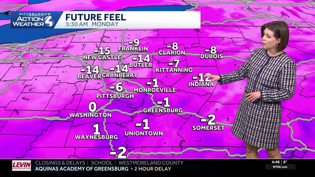
A Cold Weather Advisory is in effect until 10 a.m. for Allegheny, Armstrong, Beaver, Butler, Clarion, Indiana, Lawrence, Venango, and Westmoreland counties. Feels like temperatures could dip as low as -15 to -20 degrees. Meanwhile, the actual temperature has plunged below zero for many communities.

Hearst OwnedHearst
The frigid air plus a light breeze could lead to wind chills as low as -20 to -15 degrees this morning.
The Impact Day will be lifted once the Cold Weather Advisory expires. Today begins with a lot of sunshine. High clouds will move in late-day with highs in the upper 20s to around 30 degrees.

Hearst OwnedHearst
Sunshine with highs near 30 degrees will feel pretty good after a brutal stretch of Arctic air.
Finally above freezing Tuesday
Pittsburgh’s sub-freezing streak comes to an end tomorrow. Temperatures will begin around 20 degrees with highs surging into the low and mid 40s. Along with the warm up, isolated sprinkles and light rain showers will arrive from the south come late-day. Areas near the West Virginia border have a better chance of catching a few of those raindrops.

Hearst OwnedHearst
Temperatures surge into the 40s Tuesday. Isolated rain showers will show up late-day, especially near I-70.
The limited moisture will linger into Wednesday and produce spotty flurries. We are not expecting the snow to stick. However, the flakes and breezy conditions could briefly drop visibility.
Melt and re-freeze
High temperatures will remain near or just above freezing through the start of next week. By day we will melt the ice and snow pack. Re-freezing will be a concern each night with lows in the teens and 20s. There is a late week storm worth watching that could produce a chilly rain or even a brief period of freezing rain on Sunday.

Hearst OwnedHearst
Temperatures trend more seasonable later in the week with daily melting and re-freezing.
TODAY – Impact Day: Frigid morning with sub-zero wind chills. Seasonably cold this afternoon with mostly sunny skies. High: 29°.
TONIGHT: Turning mostly cloudy and not as cold. Low: 20°.
TUESDAY: Mostly cloudy with isolated rain showers late. High: 44°, low: 28°.
WEDNESDAY: Spotty flurries, breezy and chilly. High: 36°, low: 22°.
THURSDAY: Cloudy and slightly colder. High: 32°, low: 16°.