
After over two weeks of bitterly cold air, the thaw arrives today for western Pennsylvania. High temperatures will surge into the mid to upper 40s! The trend for the remainder of the week is more seasonable with a slow melting process.Finally, above freezing TuesdayThis morning is somewhat enjoyable, dare we say. A mild surge will push temperatures in the mid to upper 40s. Areas closer to the West Virginia border could even reach 50 degrees.A warm front guides the warm up this afternoon. Sunshine will give way to clouds. Isolated rain showers will show up this evening. Activity will be light and brief. Showers will arrive after the evening commute and wrap up before midnight. Areas south of I-70 will see a better coverage of rain, meanwhile close to I-80 will stay dry.Temperature slide into the 30sLimited moisture will linger into Wednesday and produce scattered light snow. We are not expecting much snow to stick. However, the flakes and 30 mph wind gusts could briefly drop visibility. It will feel like February again with highs in the lower 30s. High temperatures will hover close to the freezing mark with lows in the teens and lower 20s through the end of the week.Warming up over the weekendTemperatures warm again over the weekend with a high of 40 degrees. Valentine’s Day will be dry with more sunshine. We are watching a storm system that could bring chilly rain to the Pittsburgh area on Sunday. Concerns for flooding will be slightly elevated. High temperatures will push higher into the 40s early next week.TODAY: Milder with increasing clouds. High: 44°.TONIGHT: Scattered evening rain showers, mostly cloudy. Low: 28°.WEDNESDAY: Not as warmer, windy with scattered light snow showers. High: 33°, low: 22°.THURSDAY: Brisk with mostly cloudy skies. High: 30°, low: 18°.FRIDAY: More sunshine and chilly. High: 34°, low: 17°.
PITTSBURGH —
After over two weeks of bitterly cold air, the thaw arrives today for western Pennsylvania. High temperatures will surge into the mid to upper 40s! The trend for the remainder of the week is more seasonable with a slow melting process.
Finally, above freezing Tuesday
This morning is somewhat enjoyable, dare we say. A mild surge will push temperatures in the mid to upper 40s. Areas closer to the West Virginia border could even reach 50 degrees.

Hearst OwnedHearst
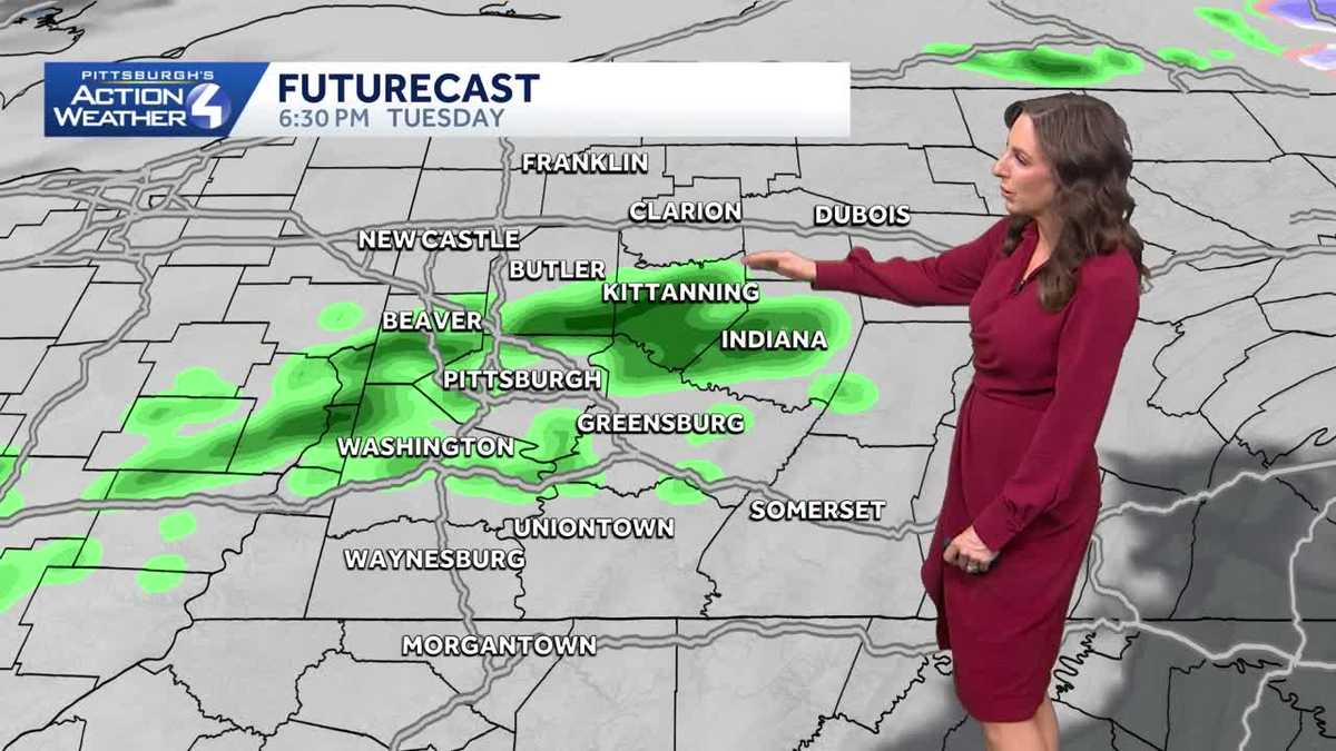
A mild surge will also lead to a rain chance. Showers will arrive after 6 p.m. and exit by midnight.
A warm front guides the warm up this afternoon. Sunshine will give way to clouds. Isolated rain showers will show up this evening. Activity will be light and brief. Showers will arrive after the evening commute and wrap up before midnight. Areas south of I-70 will see a better coverage of rain, meanwhile close to I-80 will stay dry.
Temperature slide into the 30s
Limited moisture will linger into Wednesday and produce scattered light snow. We are not expecting much snow to stick. However, the flakes and 30 mph wind gusts could briefly drop visibility. It will feel like February again with highs in the lower 30s. High temperatures will hover close to the freezing mark with lows in the teens and lower 20s through the end of the week.

Hearst OwnedHearst
A winter-like feeling returns Wednesday with scattered light snow.
Warming up over the weekend
Temperatures warm again over the weekend with a high of 40 degrees. Valentine’s Day will be dry with more sunshine. We are watching a storm system that could bring chilly rain to the Pittsburgh area on Sunday. Concerns for flooding will be slightly elevated. High temperatures will push higher into the 40s early next week.

Hearst OwnedHearst
Temperatures continue to warm over the weekend through next week.
TODAY: Milder with increasing clouds. High: 44°.
TONIGHT: Scattered evening rain showers, mostly cloudy. Low: 28°.
WEDNESDAY: Not as warmer, windy with scattered light snow showers. High: 33°, low: 22°.
THURSDAY: Brisk with mostly cloudy skies. High: 30°, low: 18°.
FRIDAY: More sunshine and chilly. High: 34°, low: 17°.