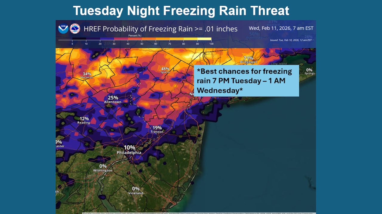
Light ice accumulation is possible Tuesday night across the northern portions of the Lehigh Valley and Poconos, with the greatest risk occurring north of Interstate 78.
The National Weather Service is monitoring the situation but has not issued a Winter Weather Advisory at this time due to low confidence in coverage and intensity.
A weak clipper system will bring a narrow band of precipitation to the region Tuesday evening as a warm front lifts across the area during the afternoon, followed by a cold front at night.
Initially, light snow is possible in the southern Poconos and northwestern New Jersey this afternoon, but the main precipitation threat comes as a southwesterly low-level jet stream enhances lift. Temperatures will be marginal for freezing, creating a battle between snow, sleet and freezing rain.
The National Weather Service forecasts a light glaze of ice accumulation, generally less than one-tenth of an inch, mostly north of I-78 and particularly across the southern Poconos to northwest New Jersey. South of I-78 toward I-95, the chance for icing is lower but not zero.
The icing threat comes as temperatures finally begin to moderate following a near-record run of winter cold.
Tuesday’s forecast high of 34 degrees at Lehigh Valley International Airport would be the first temperature recorded above the 32-degree freezing mark since a high of 34 on Jan. 23, according to the National Weather Service. This streak of 17 days at or below freezing would fall just short of the record 18-day stretch that ended Feb. 13, 1978. The 2026 streak beats the 14-day stretch at or below freezing recorded during winter 2017-18 at the airport outside Allentown.
Temperatures are forecast to drop below freezing Tuesday evening across most of the region before potentially holding steady or rising slightly as the low-level jet crosses the area ahead of the cold front’s passage.
Winds will become light and variable initially, then shift to west-northwest at 5 to 10 mph late Tuesday night.
Residents in areas north of I-78 should exercise caution on roadways and walkways this evening, as even light ice accumulation can create hazardous conditions on untreated surfaces.
Following the system, conditions will improve Wednesday with clearing skies and west-northwest wind gusts reaching 20 to 25 mph. Highs Friday and Saturday will reach the 30s to low 40s as a more significant storm system approaches the eastern seaboard.
The National Weather Service continues to monitor that storm system expected to impact the area Sunday. While uncertainty remains regarding intensity, track and timing, precipitation appears likely.
Given the mild air mass in place ahead of this system, rain or snow changing to rain is expected near and south of the urban corridor, with better chances for more significant accumulating snow across the Poconos and northwest New Jersey. Current probabilities for at least 2 inches of snow range from less than 10% near the urban corridor to 30-40% over the Poconos.
At Lehigh Valley International, the weather service forecasts a chance of snow beginning around daybreak Sunday, with snow likely at night. A slight chance of snow then continues into early Monday.
Meanwhile, significant ice cover continues across many area waterways and inland estuaries. This includes the Delaware estuary and Delaware River, which is mostly ice-covered from Delaware Bay northward to at least Washington Crossing.
River ice typically breaks up through thermal or mechanical means, requiring temperatures in the 40s for several days or significant rainfall. While daytime temperatures may briefly approach 40 degrees Tuesday afternoon and Wednesday, nighttime freezing will continue to support ice expansion this week.
Current weather radar