
SHORT TERM FORECAST
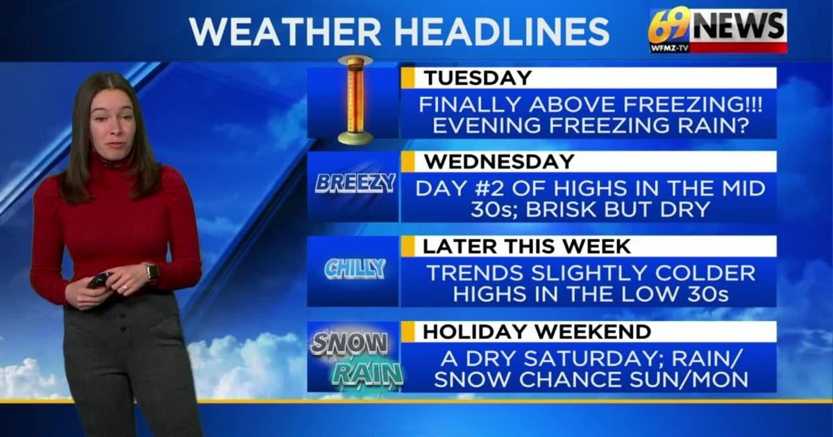
TUESDAY: Mostly cloudy and not as cold as temps finally inch above freezing; a snow shower possible in the Poconos. High: 34
TUESDAY NIGHT: Mostly cloudy and not as cold; lite drizzle or freezing rain possible. Low: 26
WEDNESDAY: Mostly cloudy. Breezy. High: 37
FORECAST SUMMARY
After 17 straight days of below freezing temperatures in the Lehigh Valley, tied for the second longest stretch on record, we will finally see the arctic air retreat, and a more seasonable air mass build in through next weekend. This spells daytime highs pushing the mid to even upper 30’s some days. Outside of a very slight chance of freezing rain if not drizzle tonight, we stay quiet until the back end of the weekend.
DETAILED FORECAST
TUESDAY AND TUESDAY NIGHT
Expect a mostly cloudy day and night, as a weak disturbance slides our way and brings plenty of clouds. It won’t have much moisture to work with, but there can be a brief snow shower or two during the day on Tuesday, mostly in the Poconos (20% chance). Despite more clouds, it will be a more seasonable day, with highs inching above freezing and into the mid 30s for the first time in weeks for many. Tuesday evening, there is a slightly better chance (30%) of a brief period of freezing rain if not drizzle. This could make for some isolated slick spots Wednesday morning.
WEDNESDAY
Skies likely remain mostly cloudy on Wednesday, and breezes pick up a bit, but it should be another day with highs in the mid 30s and slightly above freezing temperatures. With a west to northwest breeze around 10-20mph, it may feel a bit colder though, granted not nearly as cold as where we’ve been of late.
THURSDAY AND FRIDAY
We’ll inch back closer to the low 30s and the freezing mark for highs later this week, with a brisk breeze still adding a chill on Thursday. But the days look dry, with mostly cloudy skies persisting on Thursday, and a rare mostly sunny day on Friday. Nighttime lows will trend colder too, but stop before they approach bitter cold levels, as lows drop into the mid-teens both nights.
THIS WEEKEND
Presidents’ Day weekend looks to start quiet on Saturday, with partly sunny skies and highs inching back up into the mid 30s. We’ll do mid to even upper 30s Sunday and Monday, but will watch a possible low off the coast to our south and east. Depending on the track and strength of this feature, as well as how much cold air is or isn’t left in our area, rain, snow, or a mix is possible later Sunday into Monday. However, details are uncertain at this time as to how this scenario will likely unfold.
TRACK THE WEATHER:
LINKS: HOUR BY HOUR | RADAR | TRAFFIC