
TO KEEP YOUR DRIVEWAY CLEAR SO THE DELIVERY CAN GET TO YOU. NOW, THE WGAL NEWS EIGHT STORM TEAM FORECAST WITH METEOROLOGIST ETHAN HUSTON. MOST OF THE VALLEY STAYS DRY THIS EVENING AND TONIGHT, BUT WE COULD SEE SOME SPOTTY SHOWERS AND ALSO SOME PATCHY FREEZING DRIZZLE FOR OUR NORTHEASTERN VIEWERS. WE WILL SEE OUR TEMPERATURES CONTINUE TO CLIMB AS WE GO THROUGH THIS WEEK ON INTO THE WEEKEND AND EARLY NEXT WEEK. WE’RE TALKING TEMPERATURES AREA WIDE, LIKELY SITTING IN THE 40S BY VALENTINE’S DAY, AND WE ARE TRACKING AT LEAST THE CHANCE FOR SOME WINTRY WEATHER FOR YOUR SUNDAY. BUT THE CHANCES ARE GOING DOWN. WE’LL HAVE MORE ON THAT IN JUST A MOMENT. BUT IN TERMS OF THE CHANCE TO SEE SOME FREEZING DRIZZLE, NORTHERN PORTIONS OF DAUPHIN COUNTY, LEBANON COUNTY, BERKS AND SCHUYLKILL COUNTY, YOU HAVE THE BEST CHANCE TO SEE SOME OF THESE POCKETS OF SOME FREEZING DRIZZLE ELSEWHERE ACROSS THE SUSQUEHANNA VALLEY. TEMPERATURES WILL LIKELY STAY AT OR ABOVE FREEZING. SO THIS IS WHY LEBANON COUNTY, SCHUYLKILL COUNTY, BERKS COUNTY, YOU’RE UNDER A WINTER WEATHER ADVISORY UNTIL 12 A.M. TOMORROW. SO TEMPERATURES OUT THERE RIGHT NOW SITTING IN THE 30S, I DO EXPECT WE’LL JUST HOVER WHERE WE ARE RIGHT NOW AS THE CLOUDS CONTINUE TO THICKEN. IT’S ONCE WE GET CLOSER TO ABOUT 10:00, WE COULD SEE SOME SPOTTY SHOWERS OR SOME AREAS OF SOME DRIZZLE. THESE SHOWERS WILL TAPER OFF EARLY OVERNIGHT BY ABOUT 2 TO 3:00 IN THE MORNING, AND THEN TEMPERATURES WILL RISE AS THE WINDS PICK UP, AND THEY’LL STAY UP THROUGH THE DAY TOMORROW. IT’S GOING TO BE A LITTLE COOLER THAN TODAY ACROSS PARTS OF THE SUSQUEHANNA VALLEY. THAT MADE IT INTO THE 40S. I THINK MUCH OF THE VALLEY IS STAYING IN THE MID TO UPPER 30S, BUT IT IS GOING TO BE BLUSTERY OUT THERE WITH GUSTS UP TO 35MPH. MADE IT TO 36 OUT AT THE AIRPORT FOR THE HIGH TODAY, AND AGAIN, FIVE INCHES OF SNOW ON THE GROUND. THIS IS THE LONGEST STRETCH OF DAYS WE HAVE SEEN AT LEAST FIVE INCHES OF SNOW ON THE GROUND SINCE THE YEAR 2000. TAKE A LIVE LOOK RIGHT NOW OVER LANCASTER. WE JUST HAVE A THIN VEIL OF SOME HIGH LEVEL CLOUDS WHERE 35 DEGREES WITH A GENTLE BREEZE OUT OF THE SOUTH SOUTHEAST. HERE’S A LOOK AT THE NUMBERS ACROSS THE REGION 35. ALSO AN EFFORT OF 41. IF YOU’RE WATCHING US IN YORK AND 42 CURRENTLY IN GREENCASTLE. BUT IT’S FEELING LIKE SPRING OVER FAR SOUTHWESTERN PORTIONS AND WESTERN PA 54 RIGHT NOW IN PITTSBURGH AND 56 RIGHT NOW IN MORGANTOWN. WE’RE TRACKING SOME SHOWERS OFF TO OUR NORTH. THAT’S WHERE WE FIND THAT INCOMING COLD FRONT. AND NOTICE HERE ON THE PREDICTOR, JUST A SLIM CHANCE OF AN ISOLATED SHOWER OR SOME POCKETS OF SOME DRIZZLE AS WE HEAD INTO THE EARLY OVERNIGHT HOURS. BUT THEN WE’RE DRYING BACK OUT FOR TOMORROW. WE’LL HAVE LOTS OF CLOUDS. IT IS GOING TO BE BLUSTERY OUT THERE. WE’LL HAVE A BREEZY DAY OUT THERE ON THURSDAY. THIS RIDGE OF HIGH PRESSURE GETS A LITTLE CLOSER TO US, BUT WE’RE STAYING DRY FOR MUCH OF THE REST OF THE WORKWEEK ONCE WE GET PAST TONIGHT, AND IT SHOULD BE DRY FOR VALENTINE’S DAY. STILL A CHANCE WE COULD SEE THAT WINTRY MIX SWITCHING OVER TO RAIN ON SUNDAY, POSSIBLY LINGERING INTO PRESIDENT’S DAY. IT’S BECAUSE HERE’S THE STORM RIGHT NOW AND IT’S GOT A LONG WAY TO TRAVEL. BY FRIDAY, IT’S GOING TO BE OVER BAJA CALIFORNIA. BY SUNDAY MORNING, IT’S GOING TO BE OFF TO OUR SOUTHWEST. AND THEN THE QUESTION IS, WHEN DOES IT START TO TURN AND MOVE ALONG THE EAST COAST? AND THE TREND OF THIS TRACK THROUGH THE DAY TODAY HAS BEEN FARTHER TO THE SOUTH. SO WE’LL CONTINUE TO MONITOR THE CHANCE. I’M NOT READY TO WRITE THIS OFF JUST YET, SO STILL A MEDIUM CHANCE OR MODERATE CHANCE. WE COULD SEE THAT WINTRY MIX TO RAIN, BUT THE TREND IS WHAT WE CALL YOUR FRIEND HAS BEEN TRENDING TO THE FARTHER TO THE SOUTH. IF IT IMPACTS US, IT WOULD BE SUNDAY EVENING, SUNDAY NIGHT INTO EARLY MONDAY. WE WILL CONTINUE TO KEEP YOU POSTED AND FINE TUNE THE FORECAST. BUT NOTICE THAT TREND IN THE TEMPERATURES. UP. THEY GO INTO THE 40S FOR PRESIDENT’S DAY WEEKEND, AND WE STAY INTO THE 40S AS WE HEA
Scattered Showers Tonight; Patchy Freezing Drizzle For Some In South Central Pennsylvania
Highs will remain above freezing for the next 10 days.

Updated: 6:38 PM EST Feb 10, 2026
The Pennsylvania Department of Environmental Protection has issued a “Code Orange” Air Quality Alert today for Cumberland, Dauphin, Lancaster, Lebanon, and York Counties.Dense, cold air has settled near the ground, while warmer air rides above it. This puts a “lid” on the atmosphere and sets up an inversion, trapping particle pollutants like wood smoke, car exhaust, and pollutants from factories and industry near the surface. With little wind to mix the atmosphere, pollutant concentrations increase. Children, the elderly, and people with heart and respiratory conditions may want to limit strenuous activity outdoors.As a cold front passes between 8 p.m. to midnight, scattered light rain showers are possible. Temperatures will hover above freezing, then fall to 32 degrees tonight under mainly cloudy skies. Some areas of Lebanon, Berks, and Schuylkill counties may experience patchy freezing drizzle. The National Weather Service has issued a Winter Weather Advisory for Lebanon, Schuylkill, and Berks County from 6 p.m. Tuesday to midnight for a glaze of ice. No major impacts are expected.Highs will rebound to the upper 30s on Wednesday, and clouds will hang around. Sustained winds will increase to 15-25 mph from the northwest, with gusts to 35 mph, making it feel like the upper 20s.Thursday and Friday will feature partly sunny and breezy conditions. Highs will be a bit cooler, near 34 degrees on Thursday, and 36 degrees on Friday.Highs will warm to the low 40s on Saturday, which is more seasonable for mid-February. Look for mostly sunny skies on Valentine’s Day.We’re watching an area of low pressure, which will bring a possible wintry mix to rain Sunday afternoon through early Monday. The track of the storm will be key, including timing, precipitation type, and any rain/snow amounts we expect. The latest guidance as of this morning shows a track to our south with a chance of mainly rain. We’ll keep you updated as details evolve over the next several days.Next week, temperatures look milder and could actually be above average, in the mid-40s for several days starting Tuesday. Another chance of rain showers is possible by the end of the week.
The Pennsylvania Department of Environmental Protection has issued a “Code Orange” Air Quality Alert today for Cumberland, Dauphin, Lancaster, Lebanon, and York Counties.
Dense, cold air has settled near the ground, while warmer air rides above it. This puts a “lid” on the atmosphere and sets up an inversion, trapping particle pollutants like wood smoke, car exhaust, and pollutants from factories and industry near the surface. With little wind to mix the atmosphere, pollutant concentrations increase. Children, the elderly, and people with heart and respiratory conditions may want to limit strenuous activity outdoors.
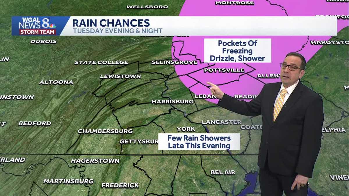
As a cold front passes between 8 p.m. to midnight, scattered light rain showers are possible. Temperatures will hover above freezing, then fall to 32 degrees tonight under mainly cloudy skies. Some areas of Lebanon, Berks, and Schuylkill counties may experience patchy freezing drizzle. The National Weather Service has issued a Winter Weather Advisory for Lebanon, Schuylkill, and Berks County from 6 p.m. Tuesday to midnight for a glaze of ice. No major impacts are expected.
Highs will rebound to the upper 30s on Wednesday, and clouds will hang around. Sustained winds will increase to 15-25 mph from the northwest, with gusts to 35 mph, making it feel like the upper 20s.
Thursday and Friday will feature partly sunny and breezy conditions. Highs will be a bit cooler, near 34 degrees on Thursday, and 36 degrees on Friday.
Highs will warm to the low 40s on Saturday, which is more seasonable for mid-February. Look for mostly sunny skies on Valentine’s Day.
We’re watching an area of low pressure, which will bring a possible wintry mix to rain Sunday afternoon through early Monday. The track of the storm will be key, including timing, precipitation type, and any rain/snow amounts we expect. The latest guidance as of this morning shows a track to our south with a chance of mainly rain. We’ll keep you updated as details evolve over the next several days.
Next week, temperatures look milder and could actually be above average, in the mid-40s for several days starting Tuesday. Another chance of rain showers is possible by the end of the week.