
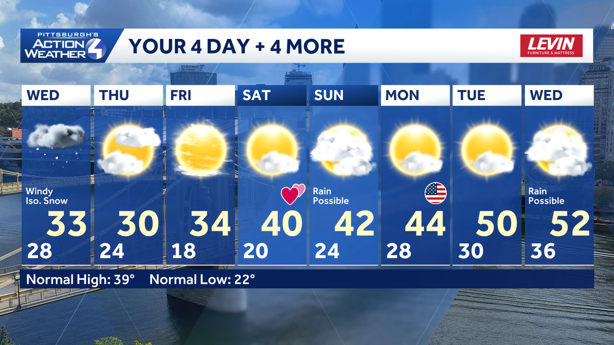
Unfortunately yesterday was a one off. The winter feeling is back for western Pennsylvania today with highs in the lower 30s. Scattered snow showers will produce minimal amounts of accumulation, but visibility issues may arise. An extended warm up begins this weekend.Back to winter: Blustery with isolated snowThe thaw sure was nice yesterday. It is back to a winter feeling today. A slow warm up will only take high temperatures to the lower 30s. It will turn windy this afternoon with gusts up to 30 mph. Wind chills will be in the mid teens to around 20 degrees.The breeze and a little moisture coming off of the lakes will produce scattered flurries for most of the area. Snow showers will be more persistent for the Laurel Highlands. Also, isolated lake enhanced bands could set up this evening north of US-422.A brief period of freezing drizzle is possible for the ridges before the snow kicks in. A Winter Weather Advisory is in effect until 3 p.m. Bridges, overpasses and bridges may become slick with the wintry precipitation.Weekend warm upHigh temperatures will hover close to the freezing mark with lows in the teens and lower 20s through the end of the week. We will work back toward plenty of sunshine by Friday. Temperatures warm again over the weekend with highs in the lower 40s. Valentine’s Day will be dry with more sunshine.We continue to watch a storm system for Sunday that could bring a period of freezing rain or snow before a chilly rain takes over. There are still track and timing questions with this potential system.Faster meltdown, flooding risk next weekThe thaw will really take off next week. High temperatures will push into the 50s by the middle of the week. A more rapid melt will elevate concerns for ice jams and flooding.TODAY: Colder and windy with isolated snow. High: 33°.TONIGHT: Snow fizzles with mostly cloudy skies. Low: 24°.THURSDAY: Brisk with sun and clouds. High: 30°, low: 18°.FRIDAY: Plenty of sunshine. High: 34°, low: 20°.SATURDAY: Mostly sunny and milder. High: 40°, low: 24°.
PITTSBURGH —
Unfortunately yesterday was a one off. The winter feeling is back for western Pennsylvania today with highs in the lower 30s. Scattered snow showers will produce minimal amounts of accumulation, but visibility issues may arise. An extended warm up begins this weekend.
Back to winter: Blustery with isolated snow
The thaw sure was nice yesterday. It is back to a winter feeling today. A slow warm up will only take high temperatures to the lower 30s. It will turn windy this afternoon with gusts up to 30 mph. Wind chills will be in the mid teens to around 20 degrees.

Hearst OwnedHearst
Back to looking and feeling like winter today. Snow showers will be more persistent for the Laurel Highlands and north of I-80.
The breeze and a little moisture coming off of the lakes will produce scattered flurries for most of the area. Snow showers will be more persistent for the Laurel Highlands. Also, isolated lake enhanced bands could set up this evening north of US-422.
A brief period of freezing drizzle is possible for the ridges before the snow kicks in. A Winter Weather Advisory is in effect until 3 p.m. Bridges, overpasses and bridges may become slick with the wintry precipitation.

Hearst Owned
A Winter Weather Advisory until 3 p.m. for the Laurel Highlands for a brief period of freezing drizzle following by light snow.
Weekend warm up
High temperatures will hover close to the freezing mark with lows in the teens and lower 20s through the end of the week. We will work back toward plenty of sunshine by Friday. Temperatures warm again over the weekend with highs in the lower 40s. Valentine’s Day will be dry with more sunshine.

Hearst OwnedHearst
We are monitoring a potential system for Sunday that could bring a period of freezing rain and/or snow followed by a chilly rain to western PA.
We continue to watch a storm system for Sunday that could bring a period of freezing rain or snow before a chilly rain takes over. There are still track and timing questions with this potential system.
Faster meltdown, flooding risk next week
The thaw will really take off next week. High temperatures will push into the 50s by the middle of the week. A more rapid melt will elevate concerns for ice jams and flooding.

Hearst OwnedHearst
The melting process will ramp up with next week’s extended warm up and rain chances.
TODAY: Colder and windy with isolated snow. High: 33°.
TONIGHT: Snow fizzles with mostly cloudy skies. Low: 24°.
THURSDAY: Brisk with sun and clouds. High: 30°, low: 18°.
FRIDAY: Plenty of sunshine. High: 34°, low: 20°.
SATURDAY: Mostly sunny and milder. High: 40°, low: 24°.