
Big Chill before warming temperatures
Big Chill before warming temperatures
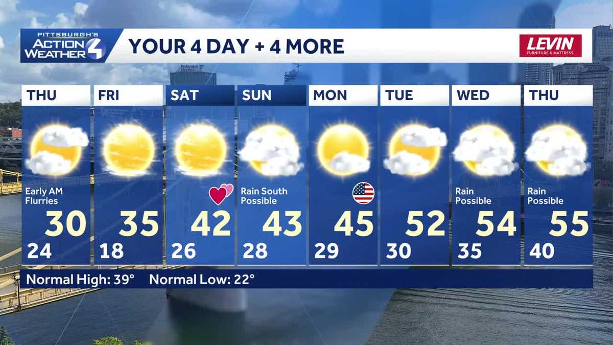
YES. AND THEN YOU’RE GOING TO RISE RAISE TEMPERATURES A LITTLE BIT THIS WEEKEND. AND TWO MORE DAYS OF CHILL. AND THEN THE WARMER TEMPERATURES ARE GOING TO KICK IN OVER THE WEEKEND AND REALLY NEXT WEEK. SO HERE ARE YOUR TWO DAYS THURSDAY AND FRIDAY A HIGH OF 30 DEGREES ON THURSDAY, SO WE DON’T EVEN MAKE THE FREEZING MARK. AND THEN ON FRIDAY OUR LOW TEMPERATURE 18 DEGREES, WE TAKE IT UP TO 35. AND THEN WE GET INTO THE WEEKEND. WE’LL HAVE SUNSHINE ON FRIDAY AND SATURDAY. HIGH TEMPERATURE OF 42 DEGREES AND THEN SUNDAY A LITTLE BIT WARMER. NEXT WEEK WE’LL SEE TEMPERATURES THAT WILL MAKE IT INTO THE 50S. SO FOR TOMORROW WE’RE IN THE 20S ALL DAY LONG. WILL TOP OUT WITH A HIGH OF 30 DEGREES. AND IT WILL BE A LITTLE WINDY OUT THERE ABOUT 10 TO 15 MILE PER HOUR WINDS. ENOUGH TO TAKE THOSE WIND CHILLS DOWN INTO THE TEENS FOR A GOOD PORTION OF THE DAY. AS WE GO THROUGH THE NEXT FOUR DAYS, TWO COLD ONES, TWO WARM ONES LOOKING FOR HIGH OF 42 AND MOSTLY SUNNY SKIES ON VALENTINE’S DAY ON SATURDAY AND THEN ON SUNDAY. MOSTLY CLOUDY, 43 DEGREES. BIG STORM GOING TO THE SOUTH OF US WILL BE RIGHT ON THE NORTHERN EDGE OF THAT, SO WE COULD SEE SOME SHOWERS POSSIBLE DOWN TO THE SOUTH. EVERYBODY ELSE WILL REMAIN DRY AND THEN WE WARM IT UP MORE 45 DEGREES ON MONDAY FOR VETERAN’S DAY. AND THEN WE GO INTO THE REST OF THE WEEK AND HIGH TEMPERATURES WILL BE IN THE 50S 52 ON TUESDAY, 54 ON WEDNESDAY AND 55 ON THURSDAY. LET’S MAKE MONDAY PRESIDENT’S DAY. LET’S GO AHEAD AND TAKE A LOOK AT WHAT’S HAPPENING AS FAR AS THE SNOW GOES UP TO THE NORTH, WE HAVE A LITTLE BIT OF SNOW, VERY LIGHT OR FLURRIES THAT ARE MOVING THROUGH THE AREA. AS WE WIDEN OUT THE SHOT HERE, YOU CAN SEE WE ACTUALLY HAVE SOME SNOW THAT’S COMING OFF THE LAKES, A LITTLE LAKE EFFECT, IT LOOKS LIKE, WHICH IS KIND OF SURPRISING BECAUSE MOST OF LAKE ERIE IS FROZEN. AND ONCE IT’S FROZEN, IT’S PRETTY LIMITED AS FAR AS HOW MUCH MOISTURE YOU CAN GET OUT OF THERE. BUT IT LOOKS LIKE THAT IS THE CASE ON LAKE HURON AND LAKE ERIE. THAT WILL CUT OFF TOMORROW AS WE GO THROUGH THE DAY. A FEW FLURRIES IN THE MORNING. IT WILL BE CLOUDY, BUT WE’LL KEEP IT DRY. AND THEN WE GO INTO FRIDAY AND WE WILL SEE THE CLOUDS THAT WILL DEPART ON FRIDAY WILL BECOME MOSTLY SUNNY. AND THEN ON SATURDAY, MOST OF US WILL SEE MOSTLY SUNNY SKIES ON SATURDAY AS WELL. TAKE A LOOK AT THE STORM COMING IN ACROSS THE COUNTRY ON SUNDAY. IT’S HUGE ALL THE WAY FROM PITTSBURGH, ALL THE WAY DOWN INTO FLORIDA, BUT WE’RE RIGHT ON THAT NORTHERN EDGE FOR THE SOUTH. A BETTER CHANCE YOU HAVE OF SEEING A LITTLE BIT OF RAIN, AND THE FURTHER NORTH YOU ARE, YOU’LL LIKELY STAY DRY WITH SOME CLOUDS AROUND, AND THAT WILL MOVE OFF AS WE GO LATER INTO THE DAY ON SUNDAY. SO YOUR 4-DAY PLUS 4 MORE LOOKS LIKE THIS. TWO COLD DAYS, TWO FAIRL
Big Chill before warming temperatures
Big Chill before warming temperatures

Updated: 8:09 PM EST Feb 11, 2026
Weekend warm upHigh temperatures will hover close to the freezing mark with lows in the teens and lower 20s through the end of the week. We will work back toward plenty of sunshine by Friday and Saturday. Temperatures warm again over the weekend with highs in the lower 40s. Valentine’s Day will be dry with more sunshine.We continue to watch a storm system for Sunday that could bring a period of rain to areas south of Pittsburgh. We are on the northern fringe of this massive storm. There are still track and timing questions with this potential system.Faster meltdown, flooding risk next weekThe thaw will really take off next week. High temperatures will push into the 50s by the middle of the week. A more rapid melt will elevate concerns for ice jams and flooding.OVERNIGHT: Snow fizzles with mostly cloudy skies. Low: 24°.THURSDAY: Brisk with sun and clouds. High: 30°, low: 18°.FRIDAY: Plenty of sunshine. High: 35°, low: 26°.SATURDAY: Mostly sunny and milder. High: 42°, low: 28°.
PITTSBURGH — Weekend warm up
High temperatures will hover close to the freezing mark with lows in the teens and lower 20s through the end of the week. We will work back toward plenty of sunshine by Friday and Saturday. Temperatures warm again over the weekend with highs in the lower 40s. Valentine’s Day will be dry with more sunshine.

Hearst Owned
We are monitoring a potential system for Sunday that could bring a period of freezing rain and/or snow followed by a chilly rain to western PA.
We continue to watch a storm system for Sunday that could bring a period of rain to areas south of Pittsburgh. We are on the northern fringe of this massive storm. There are still track and timing questions with this potential system.
Faster meltdown, flooding risk next week
The thaw will really take off next week. High temperatures will push into the 50s by the middle of the week. A more rapid melt will elevate concerns for ice jams and flooding.

Hearst Owned
Warming through the weekend with highs back into the 50s by the middle of next week.
OVERNIGHT: Snow fizzles with mostly cloudy skies. Low: 24°.
THURSDAY: Brisk with sun and clouds. High: 30°, low: 18°.
FRIDAY: Plenty of sunshine. High: 35°, low: 26°.
SATURDAY: Mostly sunny and milder. High: 42°, low: 28°.