
Warmer Temperatures Heading into the Weekend for Western PA
23RD THROUGH MARCH 2ND. RIGHT NOW WE GOT SOME SNOWFLAKES FLYING AROUND. COULD BE SOME ICY SPOTS ON THE ROADWAYS. BREEZY AND COLD THROUGH THE DAY TODAY. A COLD START ON FRIDAY BUT WILL SLOWLY WARM UP CLOSER TO 40. GETTING INTO THE 40S AS WE HEAD INTO THE WEEKEND, BUT DOES HAVE A CHANCE FOR A FEW RAIN SHOWERS. BUT LET’S ZOOM AROUND. YOU CAN SEE SOME OF THESE FLAKES. IT’S BEEN PRETTY STEADY INTO NORTHERN ALLEGHENY. ALSO IN LAWRENCE, BEAVER AND BUTLER. THROUGH THE MORNING, WE ARE NOTICING SOME LOWER VISIBILITY. NOT A LOT OF ACCUMULATION, BUT ANYTHING LEFT UNTREATED COULD BE SLICK AS THOSE ROAD TEMPERATURES ARE HOVERING AROUND 29 TO 33 DEGREES IN THE PLUM WEXFORD, ALSO EXTENDING INTO NORTHERN PORTIONS OF WESTMORELAND. SOUTHERN ARMSTRONG PUSHING NOW INTO INDIANA COUNTY, ARE SEEING SOME OF THAT LIGHT SNOW LIGHTNING UP NORTH OF 422 IN BUTLER, BUT STILL PRETTY STEADY FROM THE CITY OF BUTLER ON SOUTH DOWN ALONG 228 BUSY ROAD THIS TIME OF MORNING. ALSO 19 AND 79. AS WE GET INTO LAWRENCE AND NORTHERN BEAVER COUNTY ROUTE 18 COULD BE A LITTLE TRICKY FOR YOU. WE ARE SEEING A FEW FLAKES, ALTHOUGH LATER INTO EASTERN PORTIONS OF WASHINGTON, NORTHERN PARTS OF FAYETTE COUNTY. WIND CHILLS INTO THE TEENS AROUND SOME OF THE AREA. ACTUAL TEMPERATURES INTO THE MID TO UPPER 20S. WE’RE GOING TO STAY INTO THE TEENS. THE REAL FEEL WITH THESE WINDS GUSTING 15 TO 20MPH THROUGH THE DAY TODAY, SO IT’S DEFINITELY GOING TO FEEL LIKE WINTER FOR US, BUT SLOWLY WARMING UP AS WE GET INTO THE WEEKEND AND INTO NEXT WEEK. WITH RAIN CHANCES COMING ON SUNDAY. WE’LL TIME THAT OUT HERE IN JUST A SECOND, BUT YOU CAN SEE A LOT OF THESE SNOWFLAKES WILL BE SHUTTING OFF AS WE GET CLOSER TO LUNCHTIME. STILL BREEZY AND COLD THROUGH THE DAY, PARTLY TO MOSTLY CLOUDY SKIES INTO THE OVERNIGHT. NOW CLOUDS WILL START TO BREAK THROUGH FRIDAY AFTERNOON, GIVING US SOME MORE SUNSHINE AND WE’LL HAVE THAT SUNSHINE EXTENDING INTO OUR VALENTINE’S DAY ON SATURDAY. THERE’S YOUR FOUR DAY PLUS. FOR MORE FORECAST, HERE’S WHAT WE’RE LOOKING AT ON SUNDAY. THE TWO WEATHER MODELS THAT GO OUT A LITTLE FURTHER, ONE SHOWING IT A SOUTHERN TRACK WHICH WILL KEEP US DRY. THE OTHER CLIPS INTO ALLEGHENY AND WESTMORELAND COULD EVEN SEE A LITTLE BIT OF MIXING IN THOSE HIGHER ELEVATIONS. THE TIMING OF THAT LATE MORNING INTO THE EVENING ON SUNDAY, PRESIDENT’S DAY, STILL LOOKS DRY AND QUIET. WE WILL WARM UP INTO THE 50S
Warmer Temperatures Heading into the Weekend for Western PA

Updated: 6:32 AM EST Feb 12, 2026
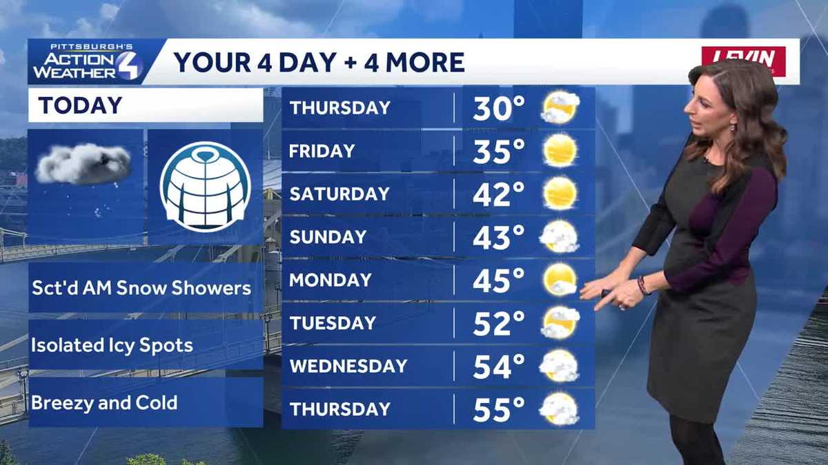
AM snow showers will taper off but cold and breezy through your Thursday.Weekend warm upHigh temperatures will hover close to the freezing mark with lows in the teens and lower 20s through the end of the week. We will work back toward plenty of sunshine by Friday and Saturday. Temperatures warm again over the weekend with highs in the lower 40s. Valentine’s Day will be dry with more sunshine.We continue to watch a storm system for Sunday that could bring a period of rain to areas south and east of Pittsburgh. We are on the northern fringe of this massive storm. There are still track and timing questions with this potential system.Faster meltdown, flooding risk next weekThe thaw will really take off next week. High temperatures will push into the 50s by the middle of the week. A more rapid melt will elevate concerns for ice jams and flooding.TODAY: Brisk with sun and clouds. High: 30°, low: 18°.FRIDAY: Plenty of sunshine. High: 35°, low: 26°.SATURDAY: Mostly sunny and milder. High: 42°, low: 28°.
AM snow showers will taper off but cold and breezy through your Thursday.
Weekend warm up
High temperatures will hover close to the freezing mark with lows in the teens and lower 20s through the end of the week. We will work back toward plenty of sunshine by Friday and Saturday. Temperatures warm again over the weekend with highs in the lower 40s. Valentine’s Day will be dry with more sunshine.

We continue to watch a storm system for Sunday that could bring a period of rain to areas south and east of Pittsburgh. We are on the northern fringe of this massive storm. There are still track and timing questions with this potential system.
Faster meltdown, flooding risk next week
The thaw will really take off next week. High temperatures will push into the 50s by the middle of the week. A more rapid melt will elevate concerns for ice jams and flooding.

TODAY: Brisk with sun and clouds. High: 30°, low: 18°.
FRIDAY: Plenty of sunshine. High: 35°, low: 26°.
SATURDAY: Mostly sunny and milder. High: 42°, low: 28°.