
Breezy & Cooler For The Rest Of The Week In South Central Pennsylvania
High temperatures will reach the upper 50s & low 60s this afternoon, with wind gusts of up to 25-30 mph.
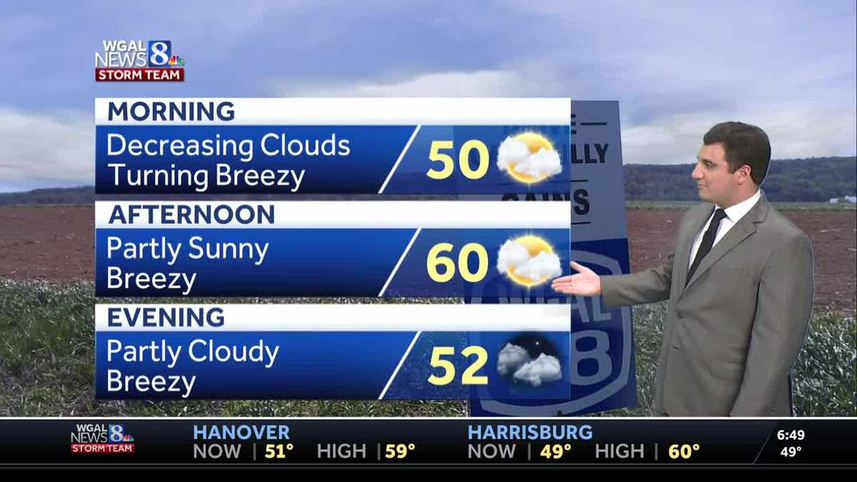
FOR THE REST OF THE WORKWEEK. IT’S COOL AND BREEZY. OUR TEMPERATURES WILL BACK OFF TO THE 60S FOR THOSE HIGHS THIS AFTERNOON. A NICE CHANGE FROM WHAT WE SAW YESTERDAY WITH A HIGH OF 70 NOW FOR THE WEEKEND. IT’S DRY AND CALMER. WE’LL SEE THOSE WINDS DIE DOWN AS WE HEAD TOWARDS THE WEEKEND AND NEXT WEEK, ESPECIALLY LATER PART OF THE WEEK. IT WILL BE UNSETTLED TOWARDS ME BY THE TIME WE GET TOWARDS HALLOWEEN, WITH RAIN CHANCES INCREASING. NOW, IN TERMS OF RAIN CHANCES RIGHT NOW ACROSS THE AREA, WE’RE DRY FOR MOST OF US, BUT UP IN MIFFLIN AND JUNIATA COUNTY, YOU CAN SEE THAT RAIN IN LEWISTOWN AREA HERE, A LITTLE BIT OF A MODERATE DOWNPOUR THERE, SOME YELLOW POPPING UP THERE ALONG TO 22 AND ALSO 322. SO JUST BE AWARE OF THAT AS YOU’RE HEADING OUT THE DOOR. AND MAYBE MIFFLIN AND JUNIATA COUNTY HERE. THIS SYSTEM IS PULLING AWAY AND BEHIND IT IS JUST GOING TO BE BREEZY AS WE GO THROUGHOUT THE AFTERNOON. SO WHAT YOU CAN EXPECT FOR THE DAY TODAY IS A HIGH AROUND 60 DEGREES AS THOSE WINDS PICK UP, AND IT WILL BE A PARTLY SUNNY AFTERNOON. 52 WILL BE THE TEMPERATURE DURING THE EVENING. OVERNIGHT LOWS WILL BE IN THE MID 40S AND SEASONABLE WITH A PARTLY CLOUDY SKY AS WE GET THROUGH TONIGHT. TOMORROW PARTLY SUNNY, BREEZY AND COOL. HIGHS ONCE AGAIN ONLY GETTING INTO THE UPPER 50S WHICH IS A LITTLE BIT BELOW AVERAGE FOR THIS TIME OF YEAR. HARRISBURG RIGHT NOW WE ARE STARTING TO SEE THE CLOUDS DECREASE ACROSS THE AREA. CURRENT CONDITIONS IN THE CITY 49 DEGREES WITH THE WINDS OUT OF THE WEST NORTHWEST AROUND THREE MILES PER HOUR. WE’LL BE WATCHING THAT INCREASE AS WE GO THROUGH THE MORNING. 49 ALSO IN CARLISLE, 48 IN ELIZABETHTOWN, 48. ALSO IN EPHRATA, 49 FOR LANCASTER, 51 IN YORK AND 52 IN CHAMBERSBURG. IT’S 45 UP IN LEWISTOWN. IF YOU’RE HEADING OUT TO THE HALLOWEEN PARADES THIS EVENING, WE HAVE A FEW OF THEM GOING ON ACROSS THE SUSQUEHANNA VALLEY WILL BE IN THE 50S, BUT IT WILL BE BREEZY AS WE GO THROUGH THE EVENING HERE. AND WHEN WE LOOK AT THE WIND GUST FORECAST, YOU CAN SEE WHY GUSTS WILL BE AROUND 25 TO 30MPH AS WE GO THROUGHOUT THE DAY TODAY. SO IF YOU HAVE TRASH DAY, JUST MAKE SURE YOU BRING THOSE CANS INSIDE BECAUSE OTHERWISE THEY COULD GET BLOWN AROUND. THE GOOD NEWS THOUGH IS IT’S COOL, BREEZY, BUT DRY AS WE GO THROUGHOUT. YOUR WEDNESDAY WILL NOT HAVE ANY RAIN TO DEAL WITH AS WE MAYBE HAVE SOME OUTDOOR PLANS TODAY OR TOMORROW. SAME THING WILL BE BREEZY AND COOL, BUT DOES LOOK DRY ACROSS THE SUSQUEHANNA VALLEY. AND THEN FRIDAY A LITTLE BIT LIGHTER. WIND WILL STILL COOL WITH TEMPERATURES IN THE 50S. IT WILL BE SEEING THOSE TEMPERATURES HERE IN THE 50S AS WE GO THROUGH TOMORROW AND ALSO YOUR FRIDAY. BUT IF YOU WANT TO TRY RAKING LEAVES, YEAH, THEY’LL BE BLOWING AROUND A LITTLE BIT WITH THE WIND, BUT OTHERWISE SHOULD BE PRETTY GOOD HERE. AND WHEN WE LOOK AT THE TEN DAY FORECAST 60 DEGREES TODAY, DROPPING DOWN TO 44 TONIGHT AND THEN 58 FOR THAT HIGH ON YOUR THURSDAY, YOU CAN SEE THURSDAY NIGHT GETTING DOWN TO 40 DEGREES. COULD EVEN SEE SOME PATCHY FROST EARLY FRIDAY MORNING. THEN AS WE HEAD TOWARDS THE WEEKEND WE’RE DRY. BACK IN THE 60S, OUR NEXT CHANCE OF RAIN WILL BE
Breezy & Cooler For The Rest Of The Week In South Central Pennsylvania
High temperatures will reach the upper 50s & low 60s this afternoon, with wind gusts of up to 25-30 mph.

Updated: 4:30 AM EDT Oct 22, 2025
Good morning,A few scattered light rain showers this morning before dawn will move out of the Susquehanna Valley. Clouds will begin to clear closer to dawn on Wednesday as a cold front crosses the region.In the wake of the cold front, afternoon high temperatures drop back to the upper 50s for the rest of the week. Each day features partly sunny skies. Overnight lows will trend into the 30s & 40s, with the coldest lows late week. We are still in the growing season in many counties, so that we may be dealing with frost concerns.Winds may gust to around 25-30 mph on Wednesday from the west, as well as on Thursday. The wind on Friday will be a bit calmer with gusts around 20 mph, but still seasonably cool with highs in the 50s.The weekend is looking mainly dry. Highs are uniform around 60 degrees both days. More clouds and a slim chance of a few showers are possible on Sunday. Most of the day is good to get outside.Weather looks quiet and cooler than average to start next week as high pressure dominates our weather pattern Monday and Tuesday. Unfortunately, it does not last much longer.An unsettled pattern begins to set up mid to late next week. Rain chances are likely for a couple of days with several fronts moving through the area. Those planning to trick or treat around Halloween should have a backup plan for showers next Friday evening. We’ll fine-tune the forecast as we get closer.Have a great day!
Good morning,
A few scattered light rain showers this morning before dawn will move out of the Susquehanna Valley. Clouds will begin to clear closer to dawn on Wednesday as a cold front crosses the region.
In the wake of the cold front, afternoon high temperatures drop back to the upper 50s for the rest of the week. Each day features partly sunny skies. Overnight lows will trend into the 30s & 40s, with the coldest lows late week. We are still in the growing season in many counties, so that we may be dealing with frost concerns.
Winds may gust to around 25-30 mph on Wednesday from the west, as well as on Thursday. The wind on Friday will be a bit calmer with gusts around 20 mph, but still seasonably cool with highs in the 50s.
The weekend is looking mainly dry. Highs are uniform around 60 degrees both days. More clouds and a slim chance of a few showers are possible on Sunday. Most of the day is good to get outside.
Weather looks quiet and cooler than average to start next week as high pressure dominates our weather pattern Monday and Tuesday. Unfortunately, it does not last much longer.
An unsettled pattern begins to set up mid to late next week. Rain chances are likely for a couple of days with several fronts moving through the area. Those planning to trick or treat around Halloween should have a backup plan for showers next Friday evening. We’ll fine-tune the forecast as we get closer.
Have a great day!