
Calm & Dry Friday & Saturday; Watching Wintry Mix Chances for Sunday In South Central Pennsylvania
Winds relax as temperatures begin to warm closer to average by Valentine’s Day. There is a chance for a rain, snow, or a wintry mix of both through the day Sunday. Impacts at this time appear to be minor.
ALL RIGHT. IT’S 449, AND WE’RE ALSO CUTE WEARING RED TODAY BECAUSE IT’S THE DAY BEFORE VALENTINE’S DAY. AND I HEAR TODAY IS GOING TO BE A LITTLE BIT SUNNY. SUNNY TODAY AND WARMER TOMORROW. MAYBE VALENTINE’S DAY PLANS EVEN A WALK OUTSIDE. THAT WOULD BE SO NICE. VERY ROMANTIC. YEAH, I THINK WE WILL BE ABLE TO DO THAT GUYS, BECAUSE WE’LL BE WARMING OUR HEARTS THIS VALENTINE’S DAY WITH HIGHS, GETTING BACK INTO THE 40S AND ACTUALLY EVEN A LITTLE BIT ABOVE AVERAGE FOR THE FIRST TIME IN SEVERAL WEEKS HERE IN THE SUSQUEHANNA VALLEY. BUT MAKE SURE YOU DO IT TOMORROW, BECAUSE SUNDAY WE WILL BE WATCHING A LITTLE STORM SYSTEM THAT PASSES MOSTLY TO THE SOUTH, BUT CLIPS OUR SOUTHERN AREAS HERE. WE’LL TALK ABOUT THAT AND WHAT YOU CAN EXPECT FOR SUNDAY. AND THEN AFTERWARDS. MILDER TEMPERATURES RETURN NEXT WEEK, AND WE ACTUALLY HAVE SEVERAL DAYS WHERE WE CAN BE ABOVE AVERAGE FOR THE FIRST TIME AGAIN IN SEVERAL WEEKS, INCLUDING IN LANCASTER. RIGHT NOW WE’VE GOT SOME CLOUD COVER AS YOU STEP OUT THIS MORNING. TEMPERATURES AT THE MOMENT 22 DEGREES AND A LIGHT WIND OUT OF THE NORTH NORTHWEST AROUND THREE MILES PER HOUR. THE WINDS TODAY WILL BE A LITTLE BIT LIGHTER THAN WHAT WE HAD YESTERDAY, BUT STILL ENOUGH. WHERE AS YOU HEAD OUT THE DOOR THIS MORNING FEELS LIKE 15 IN HARRISBURG, AS WELL AS GETTYSBURG 18. THE CURRENT WINDCHILL IN YORK FEELS LIKE 26 IN LEBANON, BUT AS WE GO THROUGHOUT THE DAY, WE’LL REACH A HIGH AROUND 36 WITH A MOSTLY SUNNY SKY. SO MAKE SURE YOU TAKE THE SUNGLASSES OUT THERE WITH YOU TODAY IF YOU HAVE THEM INSIDE, BECAUSE YOU WILL NEED THEM. AS WE GO INTO TONIGHT, WE WILL DROP BACK TO WHERE WE ARE RIGHT NOW. LOW 20S WITH INCREASING CLOUDS ACROSS THE AREA AND LIGHT WINDS WILL BE A BIT OF A CHILLY START TO YOUR SATURDAY. BUT TOMORROW FOR VALENTINE’S DAY, PARTLY SUNNY AND PLEASANT WITH HIGHS ONCE AGAIN. AGAIN BACK INTO THE MID 40S WHICH IS ABOVE AVERAGE FOR THIS TIME OF YEAR. WE SHOULD BE AROUND 41 DEGREES. STORM TEAM LIVE RADAR NETWORK. HERE. IT IS QUIET AT THE MOMENT. HIGH PRESSURE IS IN CONTROL AND THAT’S WHAT’S BRINGING US THAT NORTHWESTERLY BREEZE ACROSS THE AREA HERE. AND AS WE GO THROUGH THE REST OF THE DAY, WE CAN EXPECT MORE OF THE SAME. HIGH PRESSURE WILL BE DOMINATING OUR WEATHER PATTERN FOR OUR FRIDAY. THAT KEEPS US CALM AND SUNNY THROUGHOUT THE ENTIRE DAY. TONIGHT WE DO SEE A LITTLE BIT OF CLOUD COVER. MOVE BACK IN HERE. SOME MODELS ARE TRYING TO BRING OUT SOME FLURRIES, BUT I DON’T REALLY SEE ANY OF THAT REACHING THE GROUND. THE AIR IS JUST TOO DRY AS A COLD FRONT COMES ON THROUGH AND BEGINS TO DISSIPATE TOMORROW. SOME CLOUDS, BUT OVERALL SHOULD BE A PRETTY DECENT DAY ACROSS THE AREA. AND THEN AS WE HEAD INTO SUNDAY, WE HAVE THE CLOUDS IN PLACE HERE. AND THEN WE’RE WATCHING THIS STORM SYSTEM THAT WILL APPROACH FROM THE SOUTH. IT DOES CLIP OUR AREA HERE WITH A LITTLE BIT OF RAIN AND SNOW MIX ACROSS THE AREA ALONG AND SOUTH OF THE PENNSYLVANIA TURNPIKE. THIS MODEL TENDS TO BE A LITTLE BIT COLDER THAN OTHERS HERE. OTHERS ARE JUST SHOWING PLAIN RAIN, SO WE DO ANTICIPATE THAT MIX OF WHAT YOU CAN EXPECT IS A RELATIVELY LOW IMPACT EVENT ON SATURDAY. SUNDAY, DURING THE AFTERNOON AND EVENING HOURS HERE, AS THAT STORM WILL BE CLIPPING OUR AREA, WE AGAIN SEE THAT RAIN SNOW MIX EXPECTED ACROSS THE REGION. THE GOOD NEWS IS TEMPERATURES ARE ABOVE FREEZING IN THE AFTERNOON, SO THAT’S GOING TO WARM UP THE GROUND AND PREVENT REALLY A LOT OF ISSUES. EVEN IF WE DO SEE SOME SNOWFALL OUT OF THIS, IT REALLY ISN’T GOING TO BE STICKING TO THE ROADS BECAUSE THEY’RE GOING TO BE WARMED UP. NOW, THE IF WE DO END UP GETTING A LITTLE BIT OF SNOW ACROSS THE AREA, WE’RE LOOKING AT GENERALLY A COATING TO ONE INCH, MAYBE TWO INCHES AT SOME OF THE HIGHER ELEVATION SPOTS, BUT I THINK THAT IS VERY MUCH WISHFUL THINKING AT THIS POINT. WITH THIS, IT DOES LOOK LIKE TEMPERATURES ARE GOING TO STAY AT OR JUST ABOVE FREEZING AS WE GO INTO SUNDAY AND INCLUDING SUNDAY EVENING, SO IT’S GOING TO BE HARD FOR THAT SNOW TO STICK. THEN TEMPERATURES GO ABOVE AVERAGE AS WE GO INTO MONDAY AND NEXT WEEK. CHECK THAT OUT. COULD EVEN GET CLOSE TO THE UPPER 40S BY TUESDAY. AND BE HONEST WITH YOU, SOME OF YOU MAYBE TOUCH 50 DEGREES, ESPECIALLY IN OUR TYPICAL WARM SPOTS. LIKE FOR EXAMPLE, IN GETTYSBURG. AS WE GO INTO YOUR TUESDAY AND WE KEEP THE TEMPERATURES IN THE 40S ALL OF NEXT WEEK AS WELL, THEY WILL HOVER RIGHT AROUND AVERAGE IF NOT ABOVE AVERAGE
Calm & Dry Friday & Saturday; Watching Wintry Mix Chances for Sunday In South Central Pennsylvania
Winds relax as temperatures begin to warm closer to average by Valentine’s Day. There is a chance for a rain, snow, or a wintry mix of both through the day Sunday. Impacts at this time appear to be minor.

Updated: 5:29 AM EST Feb 13, 2026
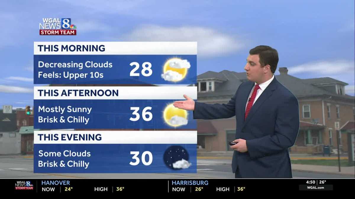
Good morning,Clouds will decrease this morning with temperatures in the 20s. Building high pressure will deliver mostly sunny skies during the afternoon and highs around 36 degrees. Winds will be lighter, so wind chills won’t be as noticeable as on previous days.Valentine’s Day will feature partly sunny skies and milder temperatures. Highs will warm to the mid-40s, which is a few degrees above average. This will be the first time highs have been above average since January 22!Sunday begins dry with a mainly cloudy sky. Temperatures will reach the upper 30s and low 40s during the afternoon. An area of low pressure will pass mainly to our south, but still close enough to bring a rain/snow chance to parts of the Susquehanna Valley, mainly south of the PA Turnpike, on Sunday afternoon into Sunday night. Overall impacts from the storm look low at this time since temperatures will be above freezing for most of the day.The rain and snow will move out for Presidents Day on Monday, leading to decreasing clouds and highs in the low 40s.Next week, temperatures could stay above average all week, reaching the mid-to-upper 40s. Overnight lows will be milder as well, in the 30s most days.A chance of rain showers is in the forecast Wednesday into Thursday, and again on Saturday.Have a great day!
Good morning,
Clouds will decrease this morning with temperatures in the 20s. Building high pressure will deliver mostly sunny skies during the afternoon and highs around 36 degrees. Winds will be lighter, so wind chills won’t be as noticeable as on previous days.
Valentine’s Day will feature partly sunny skies and milder temperatures. Highs will warm to the mid-40s, which is a few degrees above average. This will be the first time highs have been above average since January 22!
Sunday begins dry with a mainly cloudy sky. Temperatures will reach the upper 30s and low 40s during the afternoon. An area of low pressure will pass mainly to our south, but still close enough to bring a rain/snow chance to parts of the Susquehanna Valley, mainly south of the PA Turnpike, on Sunday afternoon into Sunday night. Overall impacts from the storm look low at this time since temperatures will be above freezing for most of the day.
The rain and snow will move out for Presidents Day on Monday, leading to decreasing clouds and highs in the low 40s.
Next week, temperatures could stay above average all week, reaching the mid-to-upper 40s. Overnight lows will be milder as well, in the 30s most days.
A chance of rain showers is in the forecast Wednesday into Thursday, and again on Saturday.
Have a great day!