
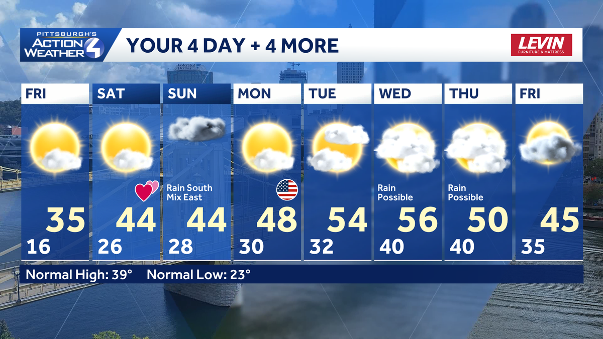
Brisk temperatures and cold wind chills today but we climb back in the 40s for the weekend. Weekend warm upExpect to see a bit more sunshine today and Saturday. Temperatures warm again over the weekend with highs in the 40s. Valentine’s Day will be dry with more sunshine.We continue to watch a storm system for Sunday that could bring some light rain to areas south of Pittsburgh. We are on the northern fringe of this storm. Everyone can expect to see more clouds on Sunday. The farther south you are located, the better chance to see rain showers.Faster meltdown, flooding risk next weekThe thaw will really take off next week. High temperatures will push into the 50s by the middle of the week. A more rapid melt will elevate concerns for ice jams and flooding.FRIDAY: Chilly, mostly sunny. High: 35, low: 26.SATURDAY: Partly cloudy and milder. High: 42, low: 28.SUNDAY: Mostly cloudy, rain showers especially south and mixing east. High: 44, low: 30.
Brisk temperatures and cold wind chills today but we climb back in the 40s for the weekend.
Weekend warm up
Expect to see a bit more sunshine today and Saturday. Temperatures warm again over the weekend with highs in the 40s. Valentine’s Day will be dry with more sunshine.

We continue to watch a storm system for Sunday that could bring some light rain to areas south of Pittsburgh. We are on the northern fringe of this storm. Everyone can expect to see more clouds on Sunday. The farther south you are located, the better chance to see rain showers.
Faster meltdown, flooding risk next week
The thaw will really take off next week. High temperatures will push into the 50s by the middle of the week. A more rapid melt will elevate concerns for ice jams and flooding.

FRIDAY: Chilly, mostly sunny. High: 35, low: 26.
SATURDAY: Partly cloudy and milder. High: 42, low: 28.
SUNDAY: Mostly cloudy, rain showers especially south and mixing east. High: 44, low: 30.