
Pittsburgh: Lovely Valentine’s Day, rain possible Sunday
Sunday’s shower chance will be confined south of Pittsburgh.
ACTION NEWS FOUR. A PRETTY NICE WEEKEND OVERALL IS IN STORE FOR US TOMORROW. THE BETTER DAY OF THE TWO WILL BE A LITTLE WARMER. MORE SUNSHINE FOR US AND DRY WATCHING FOR RAIN. CHANCE ON SUNDAY. ALTHOUGH THE MAJORITY OF US WILL BE DRY ON SUNDAY BEFORE TEMPERATURES REALLY SKYROCKET STARTING ON PRESIDENTS DAY MONDAY, THAT WILL LAST AS WE HEAD THROUGH ALL OF NEXT WEEK. 46 YOUR HIGH TEMPERATURE ON VALENTINE’S DAY. WE WILL START AT 28 BY ABOUT LUNCHTIME. WE SHOULD BE AT 40 DEGREES, SO A PRETTY NICE DAY ACROSS WESTERN PENNSYLVANIA. ANY PLANS YOU MAY HAVE? THE WEATHER WILL COOPERATE. SUNDAY. WE’RE WATCHING A RAIN CHANCE MAINLY SOUTH OF PITTSBURGH. PITTSBURGH IS ABOUT AS FAR NORTH AS ANY RAIN SHOWERS WOULD CREEP AS THE SYSTEM PASSES BY TO OUR SOUTH. LIKELY THE RAIN STAYS ALONG I-68 AND POINTS SOUTH, BUT DEPENDING ON ITS EXACT TRACK, A COUPLE OF LIGHT RAIN SHOWERS MAY MAKE IT AS FAR NORTH AS ROUTE 22, SO IT’S NOT A WASHOUT ON SUNDAY. BUT DON’T BE SURPRISED IF YOU SEE A RAIN DROP IN THE FURTHER SOUTH YOU ARE FROM PITTSBURGH, THE MORE LIKELY YOU MAY RUN INTO A RAINDROP. WE’LL START BELOW FREEZING AGAIN ON MONDAY, BUT AT 30 WE’LL FINISH AT 50 DEGREES. LOOKS GOOD FOR PRESIDENT’S DAY. A LOT OF YOU LIKELY ARE OFF WITH KIDS MAYBE GOING TO SCHOOL TO MAKE UP FOR SOME OF THOSE CLOSURES EARLIER IN THE WINTER. THE WEATHER, THOUGH, WILL BE VERY NICE. NO WEATHER CONCERNS MONDAY OR TUESDAY AT 54, AND THEN WE’LL WATCH ANOTHER SERIES OF RAIN CHANCES WEDNESDAY, THURSDAY AND FRIDAY. DESPITE THE MORE CLOUDS AND A SHOT OF A SHOWER OR TWO, LOOK AT OUR TEMPERATURES THOUGH. 56 ON WEDNESDAY, 52 ON THURSDAY, 55 ON FRIDAY. LOWS IN THE 40S. SO OUR THAW IS COMPLETELY ON AS WE HEAD THROUGH THE END OF NEXT WEEK. AND THEN WE’LL SEE A COOL DOWN TO MORE SEASONABLE LEVELS NEXT SATURDAY WITH A HIGH OF 42. SO THE ONLY BLEMISH OVER THE NEXT FEW DAYS IS THAT RAIN CHANCE SOUTH OF PITTSBURGH. AND AGAIN, THE BEST CHANCE IS LIKELY DOWN INTO WEST VIRGINIA. SKIES ARE CLEAR. WE’LL SEE A LOT OF THAT TO START THE DAY TOMORROW. 35 IS THE CURRENT TEMPERATURE AT PITTSBURGH. INTERNATIONAL WINDS ARE SOUTHWEST AT FIVE. AND THAT SOUTHWEST WIND IS GOING TO BE KEY TOMORROW. THAT STARTS BRINGING IN THE WARMER AIR. SO EVEN THOUGH WE HAVE A COOL START, IT’S A NICE FINISH AS WARMER AIR CONTINUES MARCHING INTO WESTERN PENNSYLVANIA. AGAIN, WE SHOULD BE ABOUT 40 BY LUNCHTIME. WE’LL FINISH AT 46. YOUR HIGH TEMPERATURE TOMORROW WITH WINDS STAYING FROM THE WEST SOUTHWEST, AND TEMPERATURES KEEP WARMING AS WE HEAD INTO NEXT WEEK, WE SH
Pittsburgh: Lovely Valentine’s Day, rain possible Sunday
Sunday’s shower chance will be confined south of Pittsburgh.

Updated: 6:23 PM EST Feb 13, 2026
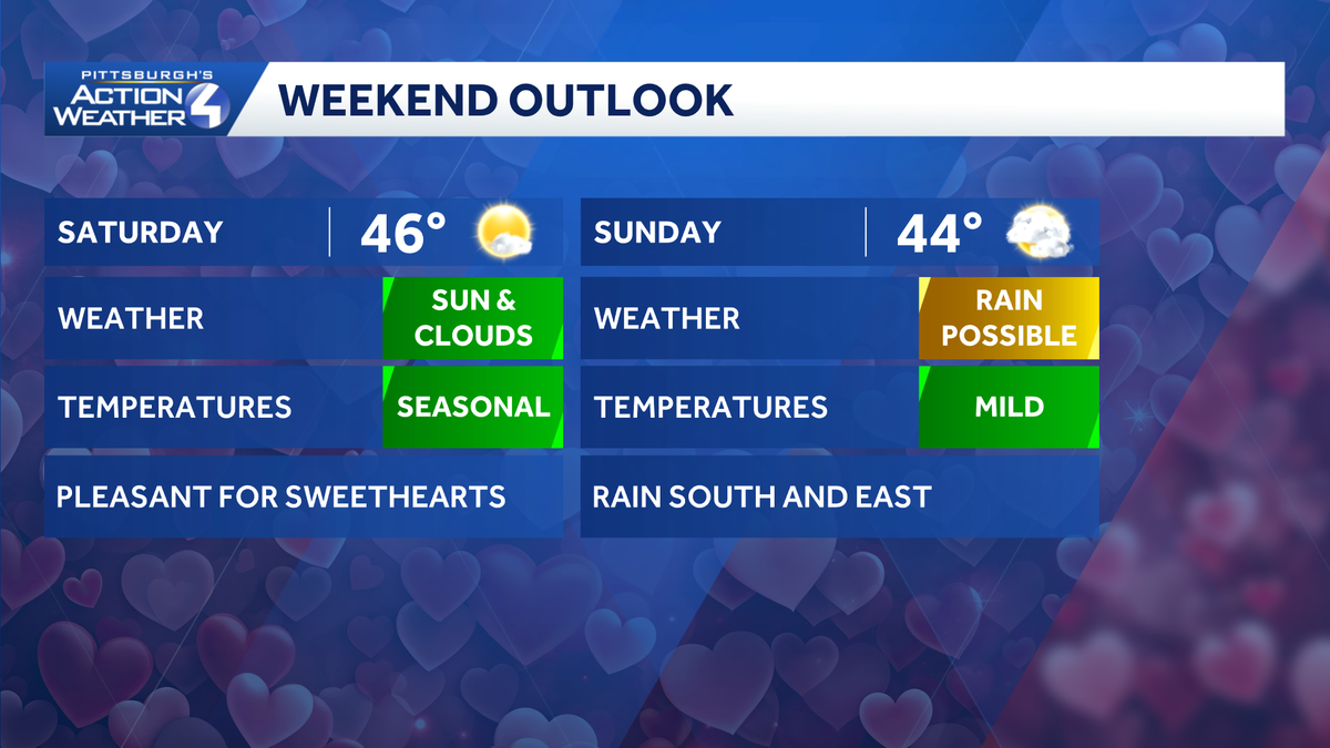
Sunshine is back heading into the weekend with temperatures warming into the 40s. We may have to watch for a shower chance south of Pittsburgh on Sunday.Weekend warm upThe weekend will start with some Saturday sunshine. Temperatures will start surging with highs in the mid 40s. Valentine’s Day should be ‘lovely’.We continue to watch a storm system that will pass to our south on Sunday that could bring some light rain to areas south of Pittsburgh. We are on the northern fringe of this storm. Everyone can expect to see more clouds on Sunday. The farther south you are located, the better chance to see rain showers in the afternoon.Thaw Continues into Next Week The thaw will really take off next week. High temperatures will push into the 50s Monday and stay there through the week. A more rapid melt could elevate concerns for ice jams and minor flooding, especially as our low temperatures stay above freezing late week. A couple of systems will pass near the area that could mean rain showers Wednesday, Thursday, and Friday.TONIGHT: Mostly clear Low: 28°.SATURDAY: Partly cloudy and milder. High: 46°, low: 32°.SUNDAY: Cloudy with showers possible south of Pittsburgh. High: 44°, low: 30°.PRESIDENTS DAY: Mostly sunny. High: 50°, low: 32°.
PITTSBURGH —
Sunshine is back heading into the weekend with temperatures warming into the 40s. We may have to watch for a shower chance south of Pittsburgh on Sunday.
Weekend warm up
The weekend will start with some Saturday sunshine. Temperatures will start surging with highs in the mid 40s. Valentine’s Day should be ‘lovely’.

Hearst Owned
A mild weekend with the only blemish being a shower chance south of Pittsburgh Sunday.
We continue to watch a storm system that will pass to our south on Sunday that could bring some light rain to areas south of Pittsburgh. We are on the northern fringe of this storm. Everyone can expect to see more clouds on Sunday. The farther south you are located, the better chance to see rain showers in the afternoon.

Hearst Owned
The farthest north rain should make it Sunday is Route 22, although rain is likely to stay south of Interstate 70.
Thaw Continues into Next Week
The thaw will really take off next week. High temperatures will push into the 50s Monday and stay there through the week. A more rapid melt could elevate concerns for ice jams and minor flooding, especially as our low temperatures stay above freezing late week. A couple of systems will pass near the area that could mean rain showers Wednesday, Thursday, and Friday.

Hearst Owned
Warmer weather is here to stay for at least a week with a few chances at rain.
TONIGHT: Mostly clear Low: 28°.
SATURDAY: Partly cloudy and milder. High: 46°, low: 32°.
SUNDAY: Cloudy with showers possible south of Pittsburgh. High: 44°, low: 30°.
PRESIDENTS DAY: Mostly sunny. High: 50°, low: 32°.