
Increasing clouds late; chance of light rain/snow mix Sunday in south-central Pennsylvania
Light rain develops Sunday afternoon and may mix with snow as temperatures drop towards late in the evening. This is a minor impact system with temperatures likely above freezing.
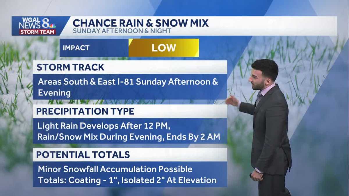
COMPROMISE IS REACHED. REPORTING ON CAPITOL HILL. I’M JACKIE DEFUSCO. NOW WGAL NEWS EIGHT STORM TEAM FORECAST WITH METEOROLOGIST BRIAN ARGENTE. WEATHER HEADLINES FOR THE NEXT SEVERAL DAYS. WHAT WE’RE FOCUSING ON IS THAT WE’RE GOING TO BE CLOUDING UP AS WE GET INTO TONIGHT. SO INCREASING CLOUDS, ALTHOUGH IT’S FEELING MUCH MORE SEASONABLE FOR THIS TIME OF THE YEAR. THEN ALL EYES ARE ON SUNDAY RIGHT NOW, ESPECIALLY FOR THE AFTERNOON, GETTING LATE INTO THE EVENING. WE ARE EXPECTING A CHANCE OF SOME LIGHT RAIN TO A RAIN SNOW MIX DURING THAT TIME FRAME, THEN HEADING INTO NEXT WEEK, MILDER TEMPERATURES RETURN AND SO WE’LL BE SEEING SOME MID 40S, EVEN SOME UPPER 40S, ESPECIALLY AS YOU’LL SEE IN THE TEN DAY FORECAST IN JUST A FEW MINUTES. SO INCREASING CLOUDS FOR THIS EVENING THEN FOR TONIGHT MOSTLY CLOUDY WITH SOME CALM WINDS. LOWS DROPPING DOWN TOWARDS THE UPPER 20S AND WE’LL GET TO THE 40S ONCE AGAIN FOR TOMORROW. WILL REMAIN OVERCAST. THAT’S ALL THANKS TO THAT SYSTEM THAT’S GOING TO START TO PUSH IN AND ALLOW THAT CHANCE OF SOME LIGHT RAIN SNOW MIX, ESPECIALLY FOR THE AFTERNOON AND THE EVENING, WHICH WE’LL HAVE FULL DETAILS, BY THE WAY, COMING UP HERE IN JUST A COUPLE OF MINUTES WITH WITH SUNDAY’S FORECAST. BUT ALMANAC FOR THE DAY TODAY 48 WAS THE HIGH WAS WHAT WE REACHED IN THE AVERAGE FOR THIS TIME OF YEAR IS 42. SO DEFINITELY IT’S IT’S NICE TO SEE SOME ABOVE AVERAGE TEMPERATURES. WHILE WE WE WERE SEEING, YOU KNOW, SEVERAL DAYS AGO WAY BELOW AVERAGE TEMPERATURES. SO IT’S REFRESHING TO SEE SOME OF THE MILD THE MILDER TREND. ALTHOUGH WE DID GET A VERY SMALL TRACE OF SOME SNOWFALL. ACCORDING TO THE CLIMATOLOGICAL REPORT WE RECEIVED FROM HARRISBURG INTERNATIONAL. SO TEMPERATURES RIGHT NOW INTO THE 40S FOR 42 IN HARRISBURG, 45 IN CARLISLE, 47 IN CHAMBERSBURG AT THIS TIME GOT A LIGHT WIND COMING OUT OF THE WEST, BUT NOT REALLY HAVING AN EFFECT ON ANY OF THE FEELS LIKE TEMPERATURES. THE WIND CHILLS. DEFINITELY JUST A LIGHT TO OR LIGHT AND VARIABLE BREEZE ACROSS THE AREA. SO STORM TEAM, LIVE RADAR NETWORK ALL IS QUIET RIGHT NOW. YOU CAN SEE SOME MAINLY CLEAR CONDITIONS, ALTHOUGH YOU CAN SEE ON THE SATELLITE IMAGERY I OVERLAID HERE. THAT’S BEGINNING. SOME OF THESE HIGH CLOUDS ARE BEGINNING TO MOVE IN FROM THE SOUTHWEST. AND THAT’S ALL THANKS TO THIS SYSTEM THAT’S OVER TOWARDS THE SOUTHERN GREAT PLAINS, OR AT LEAST THE CENTER OF THE LOW PRESSURE SYSTEM IS JUST TOWARDS NORTHERN TEXAS AT THIS POINT, AND IT IS PRODUCING SOME SEVERE WEATHER AT THIS TIME, CLOSING IN INTO EASTERN PORTIONS OF TEXAS, MOVING INTO THE MISSISSIPPI RIVER VALLEY. BUT EVENTUALLY WE’RE GOING TO START TO SEE THIS SYSTEM MOVE INTO THE SUSQUEHANNA VALLEY, ALLOWING FOR THE CHANCE OF RAIN AND ALSO SOME SNOW. SO LET’S BREAK IT DOWN AND TIME IT OUT FOR YOU. SO GETTING INTO OUR SUNDAY MORNING, THAT’S WHEN THE CLOUDS HAVE ALREADY INCREASED. WE’RE LOOKING AT MOSTLY CLOUDY CONDITIONS ONCE WE GET INTO LATER INTO THE MORNING AND EARLY AFTERNOON POTENTIALLY. THAT’S WHEN WE’LL START TO SEE THE OUTER BANDS OF THIS SYSTEM BEGIN TO PUSH THROUGH. NOW I’M GOING TO MAKE A SIDE NOTE HERE. FOR THOSE OF YOU WATCHING RIGHT NOW, THERE HAVE BEEN A THERE’S BEEN A LOT OF MODEL SPREAD RIGHT NOW IN TERMS OF THE DATA. SO WE HAVE SEVERAL MODELS THAT WE’RE LOOKING AT. THERE’S BEEN A LOT OF SPREAD AND A LOT OF DISAGREEMENT, AND NOT A LOT OF CONSISTENCY IN THE MODELS. YOU’VE BEEN HEARING US TALK ABOUT, ESPECIALLY IN THE PAST WINTER STORMS. WE WANT TO SEE CONSISTENCY IN THIS MODEL DATA. THERE’S NOT A LOT OF CONSISTENCY WITH THESE MODELS THAT HAVE BEEN WITH THIS SYSTEM CURRENTLY. BUT THIS IS OUR THIS IS WHAT WE’RE SEEING RIGHT NOW. WE’RE SEEING THE CHANCE FOR THIS LIGHT RAIN TO BEGIN TO MOVE INTO THE SUSQUEHANNA VALLEY. WHAT WE’RE WATCHING IS THIS RAIN SNOW LINE. THERE’S A LOT OF DISAGREEMENT BETWEEN WHERE THIS LINE IS GOING TO BE SETTING UP. ALTHOUGH WE DO BELIEVE THAT WE COULD BE SEEING A LITTLE BIT OF SOME SNOW AGAIN, THAT CHANGEOVER FROM RAIN TO SNOW TO BE ABLE TO COME IN SUNDAY NIGHT, GETTING INTO VERY EARLY MONDAY. BUT LOOK HOW QUICK THE SYSTEM MOVES OUT OF HERE. YOU SEE THAT IT’S OUT OF THE AREA BY THE TIME WE’RE IN MONDAY MORNING. SO NOT REALLY LOOKING AT A LOT OF ACCUMULATION WITH THIS SYSTEM REALLY LOOKING ONLY ABOUT A COATING TO ONE INCH OF SOME SNOW, AS YOU SEE HERE WITH PREDICTOR SNOWFALL AND SLEET REALLY COATING TO AT MAXIMUM TWO INCHES POTENTIALLY. BUT THAT’S FOR THE HIGHEST ELEVATIONS IN THE SUSQUEHANNA VALLEY. SO JUST DETAILING IT OUT FOR YOU. SO THE STORM TRACK OF THIS, IT’S SOUTH AND EAST OF I-81 SUNDAY AFTERNOON INTO THE EVENING. LIGHT RAIN DEVELOPS AFTERNOON FOR THE MAJORITY OF THE AREA. THEN WE’LL START TO SEE THAT RAIN SNOW MIX DURING THE EVENING, ENDING BY 2:00 IN THE MORNING FOR YOUR MONDAY, AND ONCE AGAIN ONLY REALLY SEEING ABOUT A COATING TO ONE INCH OF SOME SNOW FOR THE MAJORITY OF THE AREA. NOW, LOOKING AHEAD INTO NEXT WEEK, LOOK AT THIS MILDER TREND KICKING IN FOR YOUR MONDAY AND TUESDAY INTO THE 40S WILL GO ALSO LOOKING A LITTLE BIT UNSETTLED. WE’LL CONTINU
Increasing clouds late; chance of light rain/snow mix Sunday in south-central Pennsylvania
Light rain develops Sunday afternoon and may mix with snow as temperatures drop towards late in the evening. This is a minor impact system with temperatures likely above freezing.

Updated: 6:36 PM EST Feb 14, 2026
Skies have remained mainly clear through the evening, but as our next system approaches the Valley, clouds will begin to increase late.Mostly cloudy conditions will tonight, and lows are close to seasonable averages in the mid to upper 20s.Sunday begins dry and cloudy. Highs top out in the low 40s. An area of low pressure will pass mainly to our south but is trending north on recent models. It will bring a chance for light rain after the noon hour, which will transition to light rain mix to snow to parts of the Susquehanna Valley. Overall impacts from the storm look low at this time since temperatures will be above freezing for most of the day. A coating up to 1 inch is possible. Isolated amounts in higher elevations may exceed an inch but stay below 2 inches.The rain/snow will move out early Monday morning. The rest of President’s Day is dry with decreasing clouds and highs in the low to mid 40s.Next week, temperatures stay above average all week, reaching the mid-to-upper 40s. Overnight lows will also be milder, in the 30s most days.A chance of rain showers is in the forecast Wednesday into Thursday and Friday into Saturday.
Skies have remained mainly clear through the evening, but as our next system approaches the Valley, clouds will begin to increase late.
Mostly cloudy conditions will tonight, and lows are close to seasonable averages in the mid to upper 20s.
Sunday begins dry and cloudy. Highs top out in the low 40s. An area of low pressure will pass mainly to our south but is trending north on recent models. It will bring a chance for light rain after the noon hour, which will transition to light rain mix to snow to parts of the Susquehanna Valley. Overall impacts from the storm look low at this time since temperatures will be above freezing for most of the day. A coating up to 1 inch is possible. Isolated amounts in higher elevations may exceed an inch but stay below 2 inches.
The rain/snow will move out early Monday morning. The rest of President’s Day is dry with decreasing clouds and highs in the low to mid 40s.
Next week, temperatures stay above average all week, reaching the mid-to-upper 40s. Overnight lows will also be milder, in the 30s most days.
A chance of rain showers is in the forecast Wednesday into Thursday and Friday into Saturday.