
Dry & cloudy start to Sunday, then PM rain/snow mix late in south-central Pennsylvania
Light rain develops Sunday afternoon and may mix with snow as temperatures drop towards late in the evening. This is a minor impact system with temperatures likely above freezing.
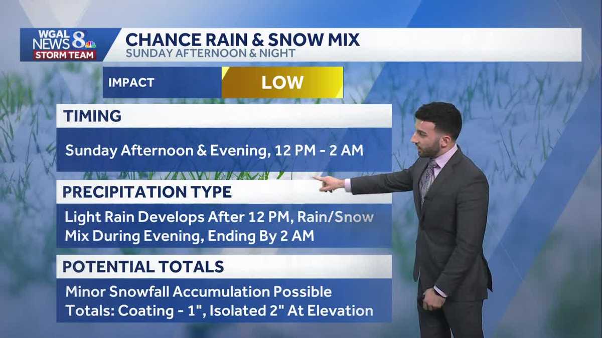
UP ON HER. I’M JENN SULLIVAN, REPORTING. NOW, THE WGAL NEWS EIGHT STORM TEAM FORECAST WITH METEOROLOGIST BRIAN ARGENTE. IN TERMS OF THE WEATHER HEADLINES, WE’RE SEEING INCREASING CLOUDS AS WE HEAD INTO THE OVERNIGHT PERIOD. WE’RE FEELING A LITTLE MORE SEASONABLE FOR THIS TIME OF YEAR. ALSO, GETTING INTO OUR SUNDAY, WE’RE LOOKING AT A CHANCE OF THAT LIGHT RAIN, THEN TO RAIN AND SNOW MIX FOR THE AFTERNOON. GETTING INTO THE EVENING, WE’RE THINKING THE TIMING BETWEEN 12 NOON AND THEN 2 A.M. MONDAY. THAT’S GOING TO BE THE DURATION OF THIS EVENT THAT WE’RE GOING TO BE EXPERIENCING FOR TOMORROW. MORE ON THAT IN A COUPLE OF MINUTES. AND THEN MILDER TEMPERATURES RETURN FOR NEXT WEEK. SO A LOT OF PEOPLE HAVE BEEN ASKING WHEN’S THAT MILDER WEATHER COMING? RYAN IT’S COMING NEXT WEEK. SO DON’T WORRY, DON’T WORRY, IT’S COMING. MOSTLY CLOUDY CONDITIONS FEELING NEAR AVERAGE FOR TONIGHT. CALM WINDS 26 TO 30 DEGREES. THEN FOR TOMORROW MORNING. CLOUDY GOT CALM. WINDS WILL BE LIGHT AND VARIABLE IN NATURE, BUT TEMPERATURES WILL BE INTO THE LOWER 30S. THEN FOR THE AFTERNOON, WE RISE TO THE 40S. WILL BE RIGHT DOWN TO THE LOWER 40S RANGE IN OUR 4042 DEGREES WITH OVERCAST CONDITIONS WITH LIGHT AFTERNOON RAIN AND SNOW SHOWERS POSSIBLE, BUT MORE SO LOOKING AT THAT SNOW CHANCE COMING IN LATER IN THE EVENING. AGAIN, WE’LL CHAT ABOUT THAT HERE IN JUST A MINUTE OR TWO. BUT THOSE OF YOU RACE FANS OUT THERE, HERE COMES BIG DAY TOMORROW. DAYTONA 500 STARTING MOSTLY SUNNY, BUT WE’RE LOOKING AT A CHANCE OF SOME SHOWERS THAT WILL BEGIN TO ROLL IN. IT’S GOING TO BE BREEZY. LOOK AT THIS SOUTHERLY BREEZE. 10 TO 20MPH. GUSTS TO 30MPH AT TIMES, SO HOPEFULLY THE DRIVERS WON’T HAVE TOO MUCH OF AN ISSUE WITH THE WINDS THERE. BUT THERE IS A CHANCE OF A THUNDERSTORM LATE 76 TO 80 DEGREES. MAN, THAT SOUNDS THAT SOUNDS INCREDIBLE. RIGHT NOW TO THE INTO THE 70S. THOSE OF YOU WHO ARE WARM WEATHER LOVERS OUT THERE, 48 DEGREES IS THE HIGH FOR TODAY. AVERAGE FOR THIS TIME OF YEAR IS 42. HAD ABOUT A TRACE OF SOME SNOWFALL FROM HARRISBURG INTERNATIONAL AIRPORT. YOU CAN SEE TEMPERATURES INTO THE 20S. KIND OF A BIT OF A WIDE RANGE HERE. THAT’S ALSO THANKS TO SOME OF THAT SNOWPACK THAT WE’RE SEEING IN MOST OF THE SUSQUEHANNA VALLEY. GOT A STRAY 42 AND 46 DEGREE READING IN CHAMBERSBURG AND GETTYSBURG. BUT CALM WINDS OUT OF THE WEST, NOT REALLY LOOKING AT MUCH OF A OF A WINDY NIGHT FOR TONIGHT. NOW STORM TEAM LIVE RADAR NETWORK OVER THE SATELLITE PRODUCT HERE. SO YOU CAN KIND OF SEE WHERE THESE CLOUDS ARE AT. THEY’RE BEGINNING TO INCREASE. AND THAT’S ALL THANKS TO THE SYSTEM THAT’S NOW DOWN TOWARDS THE SOUTH. BUT IT’S ALSO PRODUCING SOME TORNADO WARNINGS AT THIS POINT. THERE’S ALSO SEVERE THUNDERSTORM WARNINGS WITH TORNADO POSSIBLE TAGS. NOT FOR OUR AREA, BUT THAT’S CURRENTLY WHAT THIS SYSTEM THAT’S GOING TO MOVE INTO THE SUSQUEHANNA VALLEY. IT’S GOING TO BE BRINGING THAT PRECIPITATION CHANCE. SO THAT’S WHAT WE’RE GOING TO BE WATCHING. SO SO HERE’S A SUSQUEHANNA VALLEY YOU CAN SEE AS WE GET INTO OR PROCEED THROUGH THE NEXT SEVERAL HOURS, WE START DRY FOR OUR SUNDAY. SO SUNDAY MORNING SERVICES JUST KEEP IN MIND IT’S GOING TO BE A LITTLE BIT DRY. BUT YOU’LL STILL SEE MOSTLY CLOUDY CONDITIONS. IT WON’T BE UNTIL WE GET TO ABOUT NOON 1:00 IN THE AFTERNOON, WHEN SOME OF THAT PRECIPITATION BEGINS TO ENTER INTO OUR WESTERNMOST COUNTIES AND THEN BEGINS TO OVERSPREAD THE SUSQUEHANNA VALLEY. BUT NOTICE THIS. LOOK AT THIS. THIS IS WHAT WE’RE WATCHING IS THIS IS WHAT WE CALL THE RAIN SNOW LINE, WHERE WE COULD BE SEEING THAT MIX OF SOME RAIN AND SOME SNOW RIGHT NOW. AND I SAID THIS EARLIER IN THE NEWSCAST, THE MODEL DATA IS NOW BECOMING A LITTLE BIT MORE CONSISTENT OR COMING INTO A BETTER CONCLUSION IN TERMS OF WHAT WE’RE GOING TO BE SEEING, WHICH IS WHICH IS GREAT NEWS. AND SO WHAT WE’RE SEEING RIGHT NOW WITH THIS SYSTEM AS IT GOES BY, AND THIS IS A THIS IS A FAST TRACKING SYSTEM, FOLKS. THIS ISN’T GOING TO BE PUTTING DOWN MUCH SNOW TO BEGIN WITH. BUT LOOKING AT MORE SO AGAIN THAT RAIN AND SNOW MIX ONCE WE GET INTO OVERNIGHT SUNDAY, GETTING INTO EARLY MONDAY, THAT STORM SYSTEM MOVES OUT BUT LEAVES MOSTLY CLOUDY CONDITIONS AND HIGH PRESSURE BEGINS TO BUILD IN THE WAKE OF THAT STORM SYSTEM. SO HERE’S THE TOTALS RIGHT NOW A COATING TO ONE INCH OF SNOW WITH AN ISOLATED CHANCE OF SEEING TWO INCHES IN SOME COMMUNITIES. LOOKING AT MAINLY THAT THAT TWO INCH SPOT IS POSSIBLE, IT WILL BE MORE SO TOWARDS THE HIGHER ELEVATIONS. SO THAT’S WHAT WE’RE EXPECTING. SOME OF THESE DETAILS FOR YOUR SUNDAY AFTERNOON IN THE NIGHT. AGAIN, HERE’S THE TIME FRAME 12 P.M. SUNDAY TILL 2 A.M. MONDAY. ALL RIGHT. LIGHT RAIN DEVELOPS AFTER 12 NOON, THEN TURNS THAT RAIN SNOW MIX DURING THE EVENING AND THEN ENDING BY 2 A.M. THERE’S THAT COATING TO ONE INCH MARK FOR YOU. AND ALSO THE ROAD CONDITIONS. WE ARE LOOKING AT SOME WET TO SLUSHY CONDITIONS FOR HIGHWAYS ON AND OFF RAMPS, SOME SIDE STREETS AND NEIGHBORHOOD STREETS COULD BE GETTING WET TO SLUSHY AS WELL, WITH JUST SOME MINOR COATING. SO TEN DAY FORECAST. YOU CAN SEE THE BETTER NEWS FOLKS. WE’RE LOOKING AT SOME MILDER WEATHER, BUT IT’S ALSO A LITTLE BIT MORE ACTIVE. I WILL SAY WE ARE TRACKING A FEW MORE CHANCES FOR SOME SHOWERS AND AL
Dry & cloudy start to Sunday, then PM rain/snow mix late in south-central Pennsylvania
Light rain develops Sunday afternoon and may mix with snow as temperatures drop towards late in the evening. This is a minor impact system with temperatures likely above freezing.

Updated: 11:40 PM EST Feb 14, 2026
As the next system approaches the Valley, sky cover will continue increasing and skies will become mostly cloudy overnight, and lows are close to seasonable averages in the mid to upper 20s.Sunday begins dry and cloudy. Highs top out in the low 40s. An area of low pressure will pass mainly to our south but is trending north on recent models. It will bring a chance for light rain after the noon hour, which will transition to light rain mix to snow to parts of the Susquehanna Valley. Overall impacts from the storm look low at this time since temperatures will be above freezing for most of the day. A coating up to 1 inch is possible. Isolated amounts in higher elevations may exceed an inch but stay below 2 inches.The rain/snow will move out early Monday morning. The rest of President’s Day is dry with decreasing clouds and highs in the low to mid 40s.Next week, temperatures stay above average all week, reaching the mid-to-upper 40s. Overnight lows will also be milder, in the 30s most days.A chance of rain showers is in the forecast Wednesday into Thursday and Friday into Saturday.
As the next system approaches the Valley, sky cover will continue increasing and skies will become mostly cloudy overnight, and lows are close to seasonable averages in the mid to upper 20s.
Sunday begins dry and cloudy. Highs top out in the low 40s. An area of low pressure will pass mainly to our south but is trending north on recent models. It will bring a chance for light rain after the noon hour, which will transition to light rain mix to snow to parts of the Susquehanna Valley. Overall impacts from the storm look low at this time since temperatures will be above freezing for most of the day. A coating up to 1 inch is possible. Isolated amounts in higher elevations may exceed an inch but stay below 2 inches.
The rain/snow will move out early Monday morning. The rest of President’s Day is dry with decreasing clouds and highs in the low to mid 40s.
Next week, temperatures stay above average all week, reaching the mid-to-upper 40s. Overnight lows will also be milder, in the 30s most days.
A chance of rain showers is in the forecast Wednesday into Thursday and Friday into Saturday.