
It won’t be quite as warm, and nowhere near as sunny as Saturday, so get the coats back out — along with the umbrella.
Dry Sunday morning and early afternoon, rain showers by late afternoon early evening, then some slushy snow transition in the late evening, overnight hours across the Delaware Valley.

CBS News Philadelphia
NEXT big change
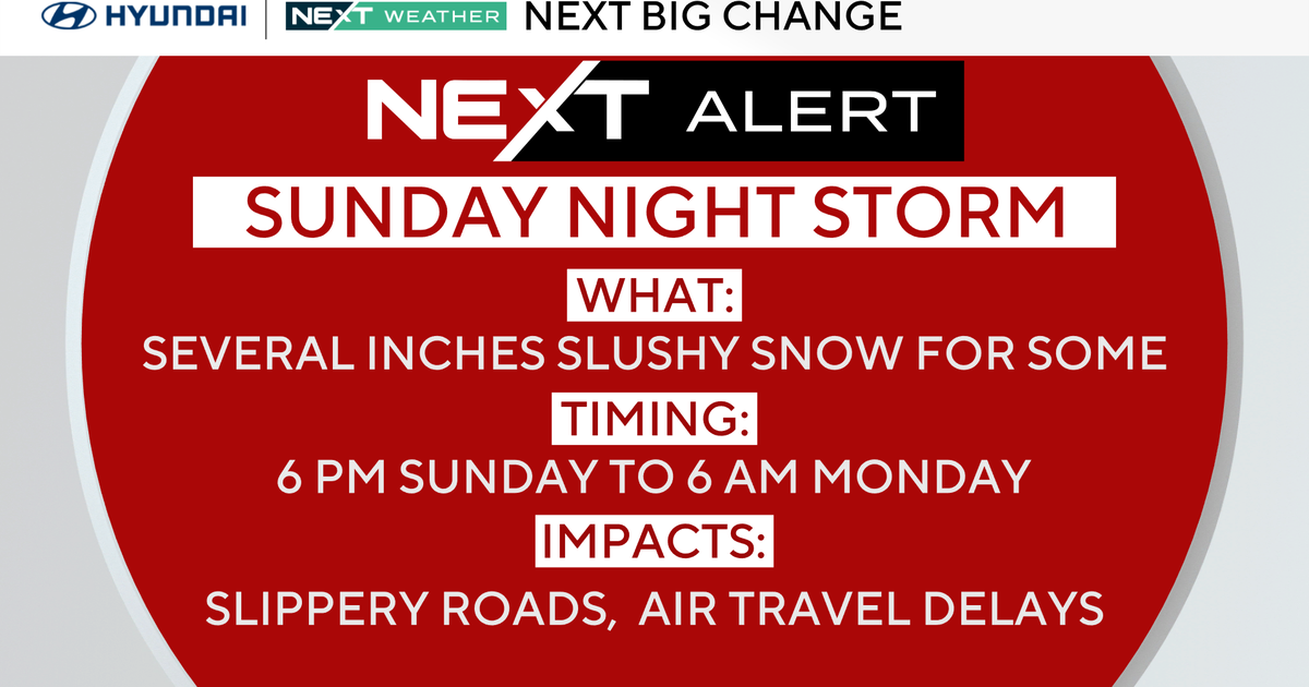
NEXT Weather Alert has been issued for Sunday evening and night as a large storm system slides past to our south.
Scattered rain showers will mix with snow in the later afternoon.
By late evening and overnight the temperatures will drop to the low and mid 30’s with rain changing to slushy snow in places. Slippery roads and air travel delays across the region. Heavy rain for those driving south on I-95 Sunday night.
About an inch of rain and a coating to 1″-2″ of wet snow in spots, mainly on grass and existing snow. Very cold air to the north will not fully phase with the storm and temperatures remain too warm for much accumulation.

CBS News Philadelphia
South Jersey and Delaware can expect rain and some minor mixing, while the I-95 corridor and our Pennsylvania counties can expect rain changing into slushy snow.
By Monday morning the storm is long gone and any slushy snow that did fall will melt quickly as temperatures rise into the 40’s.
The second big change is temperatures in the low 50’s by Tuesday and likely for the remainder of next week.
In fact, the extended outlook keeps us above freezing during the day for the next 7-10 days.
Here’s your 7-day forecast:

CBS News Philadelphia
Sunday: NEXT Weather Alert for evening rain or snow. High 42, low 30.
Monday/Presidents Day: Mostly cloudy. High 43, low 32.
Tuesday: Mostly sunny. High 51, Low 31.
Wednesday: Chance rain. High 51, low 37.
Thursday: Chance rain. High 44, low 40.
Friday: Chance rain. High 46, low 38.
Saturday: Mostly cloudy. High 39, low 37.