
Showers today, warming up this week for western PA
High temperatures will climb through the 50s, even approach 60 degrees this week.
UNTIL TEMPERATURES ARE WARM ENOUGH FOR A PERMANENT FIX. JOE WILL PROBABLY HAVE TO CONTINUE TO DODGE MORE POTHOLES AS WE GO THROUGH THE WEEK AS TEMPERATURES CONTINUE ON. WE ALSO BRING IN SOME RAIN CHANCES. IN FACT, RAIN MOVING IN AS WE SPEAK HERE ON YOUR SUNDAY MORNING. THAT SHOULD LAST THROUGH THE EARLY PARTS OF THE AFTERNOON, DRYING OUT IN TIME FOR PRESIDENT’S DAY TOMORROW. BUT THE BIG STORY WAKING UP WILL BE SOME AREAS OF DENSE FOG. BUT OVERALL, THE BIG STORY, THE BIG NEWS FOR US HEADING INTO THE NEW WEEK IS THE WARM UP RAIN CONTINUING TO BUILD ACROSS PARTS OF WASHINGTON COUNTY VERY SLOWLY HERE THIS MORNING. STARTING TO SEE SOME OF THE ACTIVITY GETTING CLOSER TO 22 AROUND THE BURGETTSTOWN AREA. NORTH STRABANE. YOU’RE STARTING TO SEE SOME RAINDROPS OUTSIDE YOUR WINDOW GETTING CLOSER TO CANONSBURG AS WELL. THAT CONTINUES ALONG I-70, SPREADING OVER INTO FAYETTE COUNTY. MEANWHILE, INTO THE HIGHER TERRAIN, YOU COULD SEE A LITTLE BIT OF MIXING, INCLUDING SOME LIGHT FREEZING RAIN, POSSIBLY EVEN SOME SNOWFLAKES AS WELL. MORE OF A CONCERN THERE. BACK THROUGH THE MOUNTAINS OF WEST VIRGINIA, THIS STORM SYSTEM JUST GOING TO GLANCE PAST US AS WE GO THROUGH THE COURSE OF THE DAY. BUT STILL SOME VERY LIGHT RAINFALL WILL BE POSSIBLE, HELPING TO MELT DOWN THAT SNOW PACK. I THINK THE COVERAGE IS GOING TO BE A LITTLE BIT MORE SPORADIC. FOR THOSE OF YOU NORTH OF THE CITY, ESPECIALLY GETTING CLOSER TO I-80. MEANWHILE, A GOOD PORTION OF TODAY’S LIGHT RAINFALL WILL BE FROM 70 ON SOUTH, WHERE CURRENTLY IS RAINING. MORE RAIN COMES OUR WAY ON WEDNESDAY. ANOTHER ROUND WILL BE HERE ON FRIDAY. IN BETWEEN WE SHOULD SEE A DECENT WARM UP COMING OUR WAY AS WELL. NOT SO MUCH OF A WARM UP FOR US TODAY. TEMPERATURES ARE GOING TO BE STUCK IN THE LOW TO MID 40S FOR THE BETTER PART OF THE AFTERNOON. HERE’S A TIMELINE OF THINGS AS WE’RE GETTING A NEW RUN OF FUTURECAST, AND WE ARE SEEING THOSE SHOWERS RIGHT NOW NEAR I-70 THAT WILL CONTINUE TO BUILD NORTHWARD THROUGH ABOUT 3 P.M. IT’S AROUND THAT TIME THAT A LOT OF THE RAIN IS GOING TO START TO SHUT OFF, ESPECIALLY WEST OF THE CITY, WEST OF I-79. PRETTY QUICKLY. WE CLEAR THAT OUT AS WE GO BETWEEN ABOUT 4:00 AND 6:00 THIS EVENING. BEYOND THAT, WE’LL WATCH THOSE AREAS OF FOG QUICKLY SETTLE IN AGAIN. THAT WILL BE A STORY TOMORROW MORNING. VISIBILITY COULD BE UNDER A MILE, AND IT COULD TAKE SOME TIME FOR US TO ACTUALLY BREAK OUT INTO SOME SUNSHINE TOMORROW WITH THOSE LOW CLOUDS. RIGHT NOW, 37 IS OUR TEMPERATURE. UNDER THOSE OVERCAST CONDITIONS, WE TAKE A LIVE LOOK OVER THE CITY OF PITTSBURGH. YOU CAN SEE A LOT OF THAT ICE HAS BROKEN UP, ESPECIALLY ALONG THE ON. TAKE SOME MORE TIME ACROSS THE ALLEGHENY AS WE CONTINUE THROUGHOUT THE DAY. AGAIN, THOSE LIGHT RAIN SHOWERS, POSSIBLE TEMPERATURES SETTLING INTO THE MID 30S TONIGHT WITH THOSE AREAS OF DENSE FOG COULD BE AN ISSUE THROUGH THE START OF THE DAY, 50 OR SO FOR A HIGH TEMPERATURE ON YOUR PRESIDENTS DAY, TEMPERATURES KEEP ON WARMING, GETTING CLOSE TO 60 BY THURSDAY COULD PROBABLY LEAVE THE JACKET AT HOME THAT DAY. WE WILL NEED THE RAIN GEAR THOUGH. WEDNESDAY A
Showers today, warming up this week for western PA
High temperatures will climb through the 50s, even approach 60 degrees this week.

Updated: 10:01 AM EST Feb 15, 2026
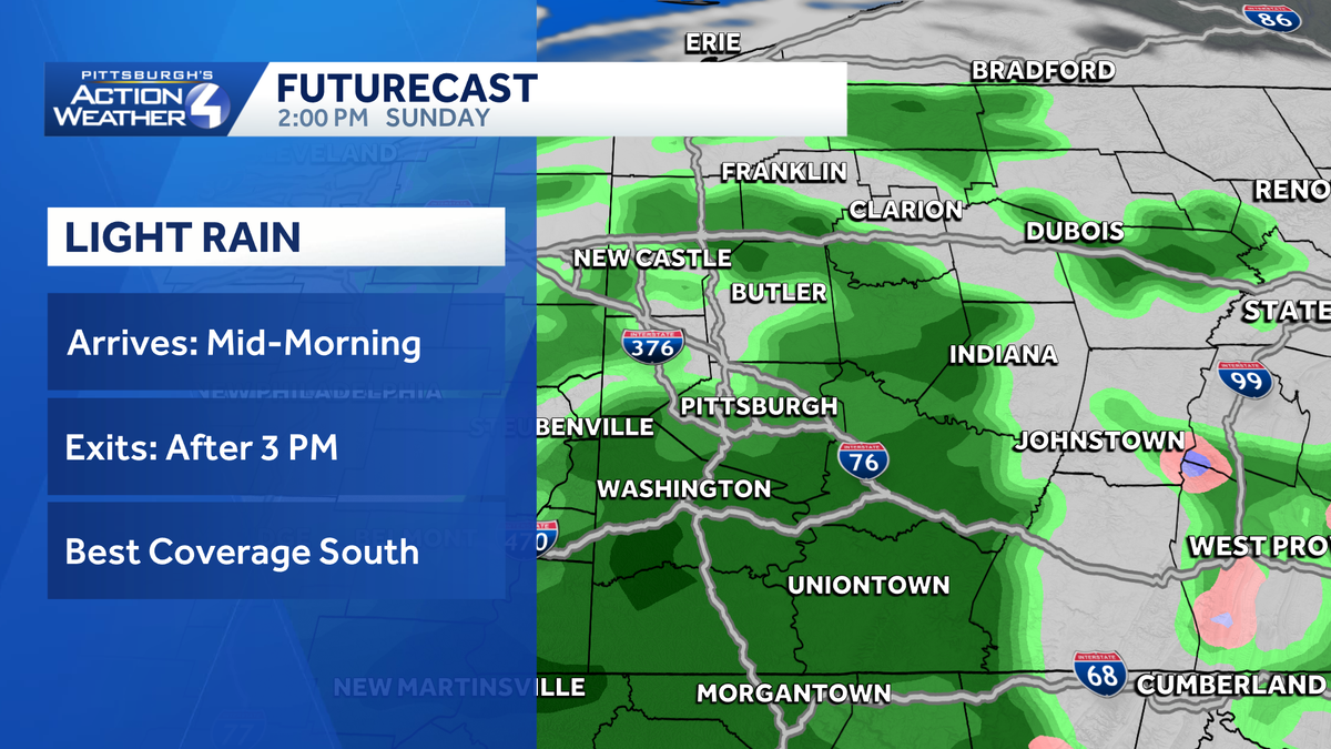
Rain moves in between late morning and mid afternoon for western Pennsylvania today. What falls from the sky will be light with rainfall amounts less than a quarter inch. We are tracking a bigger warm up and more rain chances for the week ahead.Today’s shower chanceA storm system arriving from the south brings light rain to the region today. Light showers are steadier near I-70; the coverage of the rain will be more sporadic to the north. Shower activity will fizzle after 3 p.m. or 4 p.m. Rainfall amounts will be light; potentially closer to 0.25″ near the West Virginia border by the time that the rain fizzles out before sunrise. Areas of fog will form this evening and linger through Presidents Day morning.Warming up this weekThe clouds and light rain showers will knock temperatures back several degrees. We will only settle for highs in the mid 40s this afternoon.The thaw will really take off this week. High temperatures will push near 50 degrees tomorrow and surge toward 60 degrees over the coming days. The snow and ice that are left will continue melting. The potential for ice jams and minor flooding are worth monitoring, especially as our low temperatures stay above freezing.More rain aids the meltdownMore light rain is possible on Wednesday and again Friday. It won’t be an all day rain, however you will want to keep the rain gear handy. Temperatures trend cooler, more seasonable by next weekend with highs in the low to mid 40s.TODAY: Showers develop, exit by mid-afternoon. Cloudy and not as warm, high: 44°.TONIGHT: Areas of fog, some dense. Chilly, low: 35°.MONDAY: Morning fog with gradual clearing. High: 49°, low: 34°.TUESDAY: Partly to mostly cloudy and warmer. High: 56°, low: 40°.WEDNESDAY: Light rain at times. High: 57°, low: 42°.
PITTSBURGH —
Rain moves in between late morning and mid afternoon for western Pennsylvania today. What falls from the sky will be light with rainfall amounts less than a quarter inch. We are tracking a bigger warm up and more rain chances for the week ahead.
Today’s shower chance
A storm system arriving from the south brings light rain to the region today. Light showers are steadier near I-70; the coverage of the rain will be more sporadic to the north. Shower activity will fizzle after 3 p.m. or 4 p.m.

Hearst OwnedHearst
A few wet hours centered around noon with light rain for western PA.
Rainfall amounts will be light; potentially closer to 0.25″ near the West Virginia border by the time that the rain fizzles out before sunrise. Areas of fog will form this evening and linger through Presidents Day morning.
Warming up this week
The clouds and light rain showers will knock temperatures back several degrees. We will only settle for highs in the mid 40s this afternoon.

Hearst OwnedHearst
Presidents Day will begin with areas of dense fog before sunshine takes over by the afternoon.
The thaw will really take off this week. High temperatures will push near 50 degrees tomorrow and surge toward 60 degrees over the coming days. The snow and ice that are left will continue melting. The potential for ice jams and minor flooding are worth monitoring, especially as our low temperatures stay above freezing.
More rain aids the meltdown
More light rain is possible on Wednesday and again Friday. It won’t be an all day rain, however you will want to keep the rain gear handy. Temperatures trend cooler, more seasonable by next weekend with highs in the low to mid 40s.

Hearst OwnedHearst
A bigger warm up is ahead mid-week with rain chances on Wednesday and Friday.