
Rain develops by afternoon then mixes with snow before ending in South-Central Pennsylvania
A storm system, passing by well south of the area, will bring rain this afternoon. As temperatures fall, rain will mix with snow during the evening, then end with a brief period of snow by 2 AM.
TEAM FORECAST WITH METEOROLOGIST MARYELLEN PANN. GOOD MORNING. ALL WEEK WE’VE BEEN TRACKING A STORM SYSTEM THAT’S GOING TO PASS BY TO OUR SOUTH. HOWEVER, WE WILL SEE SOME LIGHT RAIN DEVELOPING THIS AFTERNOON AND MIXING WITH SOME SNOW AS TEMPERATURES FALL DURING THE EVENING HOURS. WE’LL HAVE MORE ON THAT IN JUST A MINUTE, BUT WE ARE GOING TO CONTINUE WITH ABOVE AVERAGE TEMPERATURES, SO WE’LL CONTINUE TO FALL OUT FROM THE SNOW AND THE COLD STRETCH THAT WE HAD RECENTLY. AND WE’LL SEE MORE CHANCES FOR SHOWERS AS WE HEAD INTO THE MIDDLE. AND LATER LATTER PART OF THE WORKWEEK, AND MAINLY IN THE FORM OF RAIN. SO SOME GOOD NEWS THERE. ALL RIGHT. SO TODAY’S SYSTEM IS A LOW IMPACT SYSTEM. IT LOOKS LIKE LIGHT RAIN WILL DEVELOP SOMETIME AFTER THE NOON HOUR IN OUR SOUTHWESTERN AREAS. NOW AREAS TO THE NORTH AND EAST, IT MAY TAKE A COUPLE MORE HOURS BEFORE LIGHT RAIN SPREADS INTO THE REGION. THE ENTIRE AREA. SO PLENTY OF DRY HOURS TO DO, SOME RUNNING AROUND TO GO TO CHURCH THIS MORNING. GO TO THE GROCERY STORE. JUST HAVE THAT UMBRELLA HANDY IF YOU’RE GOING TO BE OUT THROUGH THE AFTERNOON HOURS. IT LOOKS LIKE THIS SYSTEM WILL WRAP UP BY 2 A.M. LIGHT RAIN DEVELOPING SOUTHWEST AND THEN MOVING TO THE NORTHEAST. THAT RAIN WILL START TO MIX WITH SNOW AT HIGHER ELEVATIONS LATER IN THE AFTERNOON, AND THEN FOR MUCH OF THE AREA BY EVENING AS TEMPERATURES FALL AND JUST SOME MINOR SNOW ACCUMULATIONS POSSIBLE. I WOULD SAY A COATING TO MAYBE HALF AN INCH AND UP TO AN INCH, ESPECIALLY IN THOSE HIGHER ELEVATIONS, WHICH I’LL SHOW YOU IN JUST A MOMENT. BUT AS WE GET INTO THE EVENING AND OVERNIGHT PERIOD, WE WILL BE DEALING WITH SOME WET TO SLUSHY ROADS ON THE HIGHWAYS, ON AND OFF RAMPS, AND TEMPERATURES OVERNIGHT TONIGHT WILL BE HOVERING CLOSE TO THAT FREEZING MARK. SO WE DID MAKE IT AN IMPACT. NIGHT SIDE STREETS WET TO SLUSHY, MAYBE A MINOR COATING IN SOME PARTS OF THE AREA. NOT EVERYBODY. AND SOME OF THOSE NEIGHBORHOOD STREETS. AGAIN, NOT EVERYBODY SEEING A COATING, BUT THEY WILL BE WET TO SLUSHY. SO YOUR NEWS EIGHT STORM TEAM FORECAST TODAY CALLS FOR CLOUDY, CALM, DRY CONDITIONS THIS MORNING. TEMPERATURES RIGHT AROUND 32 DEGREES AT 9:00. THAT LIGHT RAIN WILL DEVELOP THIS AFTERNOON FROM SOUTHWEST TO NORTHEAST. TEMPERATURES RIGHT AROUND 44 DEGREES. SO IT IS A MILD AFTERNOON, A LITTLE BIT ABOVE AVERAGE. THAT’S CERTAINLY GOING TO HELP KEEP THIS MAINLY A RAIN EVENT, BUT THERE IS SOME COLD AIR IN THE UPPER LEVELS THAT WILL HELP TO TRANSITION THIS TO A MIX, ESPECIALLY THIS EVENING. YOU SEE TEMPERATURES FALLING INTO THE 30S OVERNIGHT TONIGHT, HOVERING RIGHT AROUND THAT FREEZING MARK AS THAT RAIN SNOW ENDS. SO WE WILL BE MINDFUL WATCHING OUT FOR THOSE SLICK, SLIPPERY CONDITIONS AND SLUSHY CONDITIONS. TOMORROW. MOSTLY CLOUDY. SOME LATE DAY SUN MAY MIX IN AND OUT OF THE CLOUD COVER. TEMPERATURES STILL MILD IN THE LOW 40S. RIGHT NOW. WE HAVE 25 IN HARRISBURG AND LEBANON, 28 IN LANCASTER AND LEWISTOWN. A LITTLE MILDER THERE IN CHAMBERSBURG AND GETTYSBURG, WINDS ARE MAINLY CALM IN MOST LOCATIONS. OTHERWISE THEY’RE ON THE LIGHT SIDE IF THEY DO PICK UP. SO WE HAVE CLOUDY SKIES RIGHT NOW IT’S DRY. THE LOW PRESSURE SYSTEM DOWN ACROSS OKLAHOMA, AND IT’S GOING TO CONTINUE TO PASS BY TO THE EAST, STAYING TO OUR SOUTH. BUT YOU CAN SEE HOW FAR NORTH THAT PRECIPITATION SHIELD EXTENDS. AND THAT’S THE RAIN THAT WILL BE MOVING IN HERE. SO HERE’S A LOOK AT PREDICTOR TEMPERATURES IN THE LOW 40S. THIS IS AT 130. AND YOU CAN SEE JUST SOME SPOTTY SHOWERS IN OUR SOUTHWESTERN COUNTIES. SO STILL DRY. AND OTHER PARTS OF THE AREA. SO IF YOU’RE NOT SEEING THE RAIN QUITE YET IT WILL EVENTUALLY SPREAD IN ACROSS THE AREA. NOW THIS IS 530 HIGHER ELEVATIONS. SOUTH MOUNTAIN AREAS IN BERKS COUNTY, SCHUYLKILL COUNTY, CHESTER COUNTY. WE’LL SEE THAT MIX TO SNOW, RAIN AND SNOW. AND THEN THE REST OF THE AREA. TEMPERATURES CONTINUE TO FALL. WE’LL SEE IT MIXING WITH SNOW AND THEN EVEN BRIEFLY ENDING AS A PERIOD OF SNOW AS THE STORM SYSTEM IS MAKING ITS WAY OUT OF HERE BY 2 A.M. IN THE MORNING. SO YOU CAN SEE TEMPERATURES RIGHT AT THAT 3233 DEGREE MARK. AND THEN THE REST OF YOUR MONDAY IS DRY WITH A LOT OF CLOUD COVER HANGING ON, MAYBE SOME BREAKS OF SUN AT TIMES. TUESDAY IS A LITTLE MILDER, WITH THE FRONT TO OUR NORTH AND HIGH PRESSURE OFF TO THE EAST, PROVIDING A SOUTHERLY FLOW THAT’S GOING TO GET TEMPERATURES UP CLOSE TO 50 DEGREES. HERE’S A LOOK AT THAT POTENTIAL SNOWFALL. AS I MENTIONED, A COATING UP TO AN INCH, BUT THAT INCH IS GOING TO BE IN THE HIGHER ELEVATIONS. AND ALSO, IF WE DO SEE A LITTLE MORE THAN AN INCH, AGAIN, IT WOULD BE MORE TO TOWARDS SCHUYLKILL COUNTY, BERKS COUNTY AND CHESTER COUNTY. IN THOSE HIGHER ELEVATIONS. A QUICK LOOK AT YOUR TEN DAY SHOWS TEMPERATURES ABOVE AVERAGE EVEN INTO WEDNESDAY. WE DO HAVE A CHANCE FOR SHOWERS, 44 FOR THE HIGH FEW SHOWERS THURSDAY WITH MID 40S AND MORE SHOWER CHANCES FRIDAY INTO THE
Rain develops by afternoon then mixes with snow before ending in South-Central Pennsylvania
A storm system, passing by well south of the area, will bring rain this afternoon. As temperatures fall, rain will mix with snow during the evening, then end with a brief period of snow by 2 AM.

Updated: 6:41 AM EST Feb 15, 2026
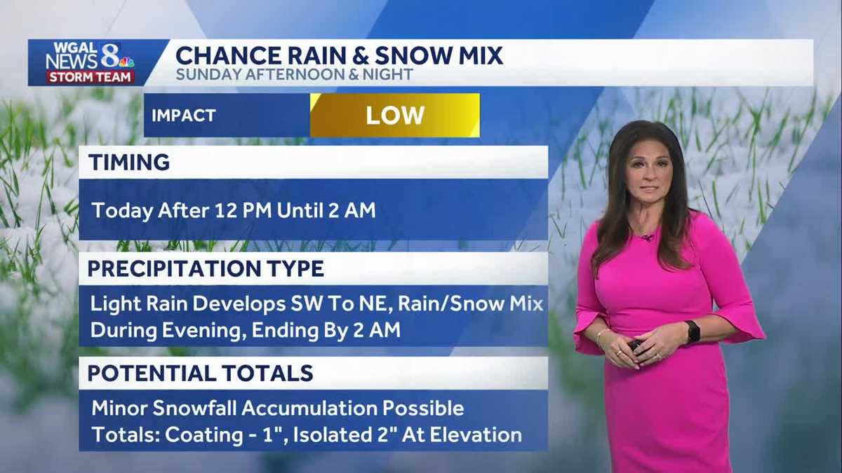
It is cloudy, dry, and calm this morning. Temperatures are mainly in the 20s.An area of low pressure will pass mainly to the south of the Susquehanna Valley and will bring a chance for light rain any time after 12 pm. Most areas will stay dry into the early afternoon, especially north and east, where it will take longer for the precipitation to arrive. Highs will peak in the low 40s, but as they fall back to the 30s, the rain will begin to mix with snow during the evening. Higher elevations will see the rain/snow mix take place earlier and linger longer. Overall impact from the storm looks low at this time since temperatures will be above freezing. However, the News 8 Storm Team has made tonight an Impact night due to temperatures dropping to near freezing. There may be slushy and slippery roads. A coating up to 1 inch is possible. Isolated amounts in higher elevations may exceed an inch but stay below 2 inches. The rain/snow will move out by 2 am Monday morning. The rest of President’s Day is dry clouds remaining stubborn. Some late day sun may mix in and out of the clouds. Highs are still at or above average in the low 40s. The mid-February thaw continues, as temperatures stay above average all week, reaching the mid-to-upper 40s around 50 degrees. Overnight lows will also be milder, in the 30s. There will be several opportunities for precipitation, mainly rain, Wednesday through Friday into next weekend. Temperatures will trend below average beginning Sunday into the following week. Have a great day!
It is cloudy, dry, and calm this morning. Temperatures are mainly in the 20s.
An area of low pressure will pass mainly to the south of the Susquehanna Valley and will bring a chance for light rain any time after 12 pm. Most areas will stay dry into the early afternoon, especially north and east, where it will take longer for the precipitation to arrive. Highs will peak in the low 40s, but as they fall back to the 30s, the rain will begin to mix with snow during the evening. Higher elevations will see the rain/snow mix take place earlier and linger longer.
Overall impact from the storm looks low at this time since temperatures will be above freezing. However, the News 8 Storm Team has made tonight an Impact night due to temperatures dropping to near freezing. There may be slushy and slippery roads. A coating up to 1 inch is possible. Isolated amounts in higher elevations may exceed an inch but stay below 2 inches.
The rain/snow will move out by 2 am Monday morning. The rest of President’s Day is dry clouds remaining stubborn. Some late day sun may mix in and out of the clouds. Highs are still at or above average in the low 40s.
The mid-February thaw continues, as temperatures stay above average all week, reaching the mid-to-upper 40s around 50 degrees. Overnight lows will also be milder, in the 30s.
There will be several opportunities for precipitation, mainly rain, Wednesday through Friday into next weekend. Temperatures will trend below average beginning Sunday into the following week.
Have a great day!