
Pittsburgh-area skies will remain cloudy today after the morning fog burns off and there’s a chance temperatures today could reach the 60 degree mark.
Any Alert Days Ahead? Keeping an eye on next Sunday, where data is showing a mix of rain and snow coming in with temperatures quickly dipping.
Aware: A dense fog advisory is in place through 11 a.m. today.
In fact, I have us hitting 60 degrees for highs on two days this week, with the first coming on Wednesday behind a morning warm front. The best chance to hit 60 degrees will probably be the following day with the same warm airmass in place, and a lower rain chance in place. I have both days seeing a high of 60 degrees right now. Even if we don’t quite get there, it will be close.
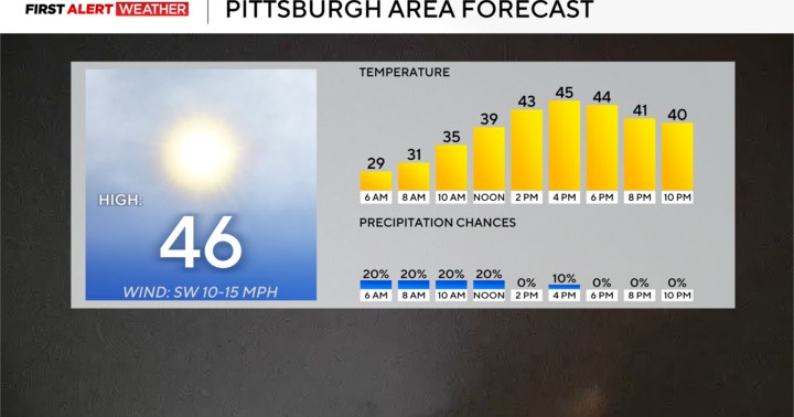
The rest of the week is also looking warm but not THAT warm. I have highs hitting the mid 40s today, with morning fog and cloud cover being the main reason for us not hitting the 50s today. I have us in the 50s on Tuesday with mostly cloudy skies.

KDKA Weather Center
The warm front arrives on Wednesday morning and brings the chance for rain our way. While most of the rest of the day is looking dry, data continues to hint at a brief line of storms being possible. The timing of this quick burst of rain right now looks to be a little early, happening before noon. If the rain arrives in the afternoon, as I think is likely, we will see our rain and storm chances increase. Wednesday’s rain wraps up early on Thursday, with most of the rest of Thursday looking dry. More rain, including storms, is expected early on Friday. Friday’s rain totals are expected to be more than a half inch put probably not more than an inch. There also appears to be at least a chance for storms, with some lightning and gusty winds possible.

KDKA Weather Center
Right now, when it comes to Friday’s rain chance, model data is all over the place with little consistency run to run and model to model. As you’d expect, Saturday to Sunday’s rain and snow chance is all over the place, with every run showing something different. A couple of things are consistent though. We are going to see another surge in cold Arctic air on Sunday, Monday, and Tuesday of next week. Looking VERY cold. We will also likely see some type of precipitation, but I am not confident right now on how much of this will be snow and how much will be just rain. Right now, I have temperatures in the mid-30s for most of the day on Sunday, and everything is showing that we are going to be close to the rain-snow line. We are watching it.
WEATHER LINKS:
Current Conditions | School Closings & Delays | Submit Your Weather Photos