
SHORT TERM FORECAST
TONIGHT: Mostly cloudy; a spotty rain or snow shower possible after midnight. Low: 34
TUESDAY: Clouds mixing with some sunshine; dry and fairly mild. High: 47
TUESDAY NIGHT: Becoming mostly cloudy. Low: 32
FORECAST SUMMARY
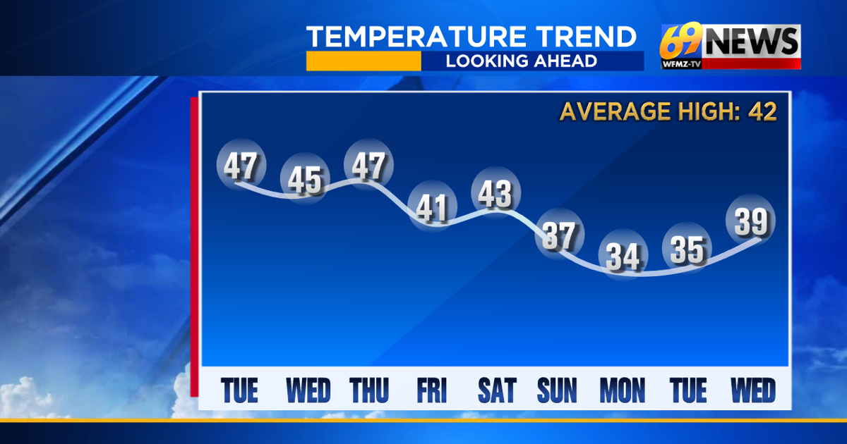
After 1 to 3 inches of snow freshened up our weeks-old snowpack Sunday night, we’re looking fairly mild the rest of the week ahead. With highs in the 40s through Saturday, we’ll actually see some slow ripening and melting of our stubborn snow cover. And the milder pattern for the rest of the week should ensure that anything else that falls this week will be rain and not snow. Right now, Wednesday and Friday offer the best chances for some rain showers, which look mostly light as there are no big storms on the radar through the start of the weekend. Temperatures may trend a bit colder early next week, but seasonably and not bitter cold from Sunday through next Monday and Tuesday. So at least for this week, there’s no arctic air or threat for accumulating snow in the forecast, at least through the end of this week.

DETAILED FORECAST
TONIGHT
Skies should remain mostly cloudy overnight, with temperatures actually remaining a bit above freezing in the mid 30s for most of us. A weak disturbance passing by to our north could bring a few spotty light rain or snow showers after midnight, mostly north of the Lehigh Valley through the Poconos and far North Jersey, but no accumulation or impact is expected with these spotty showers.
TUESDAY
Tuesday looks to be a dry day that will start with plenty of clouds, which should in turn give way for at least some sunshine. It won’t take much sun to warm us up into the mid 40s, the expected highs Tuesday afternoon. Furthermore, winds look light and from the west less than 10mph, which should make the day that much more enjoyable. Expect a slow melting of our snowpack to continue on Tuesday.
WEDNESDAY
A front will stall just to our north on Wednesday, and some moisture will ride along it, close enough to give us the chance for some occasional rain showers on Wednesday. Rain showers may be around anytime throughout the day, but a soaking or heavy rain is not expected. Right now, amounts look light, with a few hundredths of an inch farther south of the I-78 corridor, and a few tenths of an inch of rain north of it. Highs will be into the mid 40s once again, so it will be all rain showers and no snow this time around, even in the Poconos, where the rain showers will be most numerous. Any rain, plus the continued milder temperatures, should continue to promote a gradual snowmelt.
THURSDAY AND FRIDAY
That stalled-out front will linger nearby, likely ensuring mostly cloudy skies through the rest of the week. Highs will remain in the 40s as well, mid to upper 40s on Thursday, then trending cooler and closer to the 40° mark on Friday. Right now, Thursday looks mostly dry, with just the small chance of a spotty rain shower. Friday would be our next chance for some measurable rain, and looks wetter than Wednesday. Around a half inch of rain is possible on Friday and it does look like mostly rain, although the Poconos and far North Jersey may be cold enough for some wintry mix concerns, mostly in the higher elevations.
THIS WEEKEND
After Friday’s wet weather, some seasonably colder air looks to return for the weekend into early next week. Highs will remain in the low 40s on Saturday, then settle back into the 30s for Sunday and Monday. We’ll have to watch the Mid-Atlantic coast come Sunday, where low pressure may try to develop later in the weekend. If that happens, a chance of snow is possible, given the return of colder air coupled with a storm off the coast. But it’s a long way away, so we’ll wait and see if the pieces come together or not.
TRACK THE WEATHER:
LINKS: HOUR BY HOUR | RADAR | TRAFFIC