
Rain and snow has ended across the Susquehanna Valley. Roads are wet, and temperatures are holding around 32-34 degrees. Some slick spots are possible, especially on bridges and overpasses. In addition, fog is lingering, and visibility may drop down to 1 mile or less in some areas through 10 a.m. Mostly cloudy skies are in store later today, with highs in the low 40s. Winds will be light. Tonight, lows will fall to 32 degrees under mostly cloudy skies. A stray shower is possible, and areas of fog may redevelop. Tuesday will feature mostly cloudy skies to start, then breaks of sun in the afternoon. Highs will be milder, near 50 degrees. As a warm front moves north Wednesday, scattered showers are possible. Highs will hover in the upper 40s. Clouds persist Thursday, along with above average highs in the upper 40s.Late Thursday into Friday, another wet weather system will take aim at the Susquehanna Valley, leading to a chance of rain showers. Highs will be cooler at the end of the week, near 42 degrees. The active pattern continues this weekend, with a chance of rain and snow showers Saturday into Sunday. Weekend temperatures will start out in the low 40s, then end up in the upper 30s Sunday.Colder temperatures in the mid-30s are in store Monday and Tuesday next week. The good news is, we’ll finally get more sunshine!
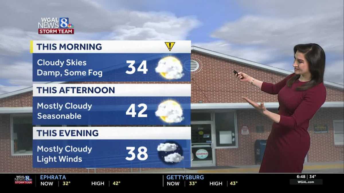
Rain and snow has ended across the Susquehanna Valley. Roads are wet, and temperatures are holding around 32-34 degrees. Some slick spots are possible, especially on bridges and overpasses. In addition, fog is lingering, and visibility may drop down to 1 mile or less in some areas through 10 a.m.
Mostly cloudy skies are in store later today, with highs in the low 40s. Winds will be light.
Tonight, lows will fall to 32 degrees under mostly cloudy skies. A stray shower is possible, and areas of fog may redevelop.
Tuesday will feature mostly cloudy skies to start, then breaks of sun in the afternoon. Highs will be milder, near 50 degrees.
As a warm front moves north Wednesday, scattered showers are possible. Highs will hover in the upper 40s.
Clouds persist Thursday, along with above average highs in the upper 40s.
Late Thursday into Friday, another wet weather system will take aim at the Susquehanna Valley, leading to a chance of rain showers. Highs will be cooler at the end of the week, near 42 degrees.
The active pattern continues this weekend, with a chance of rain and snow showers Saturday into Sunday. Weekend temperatures will start out in the low 40s, then end up in the upper 30s Sunday.
Colder temperatures in the mid-30s are in store Monday and Tuesday next week. The good news is, we’ll finally get more sunshine!