
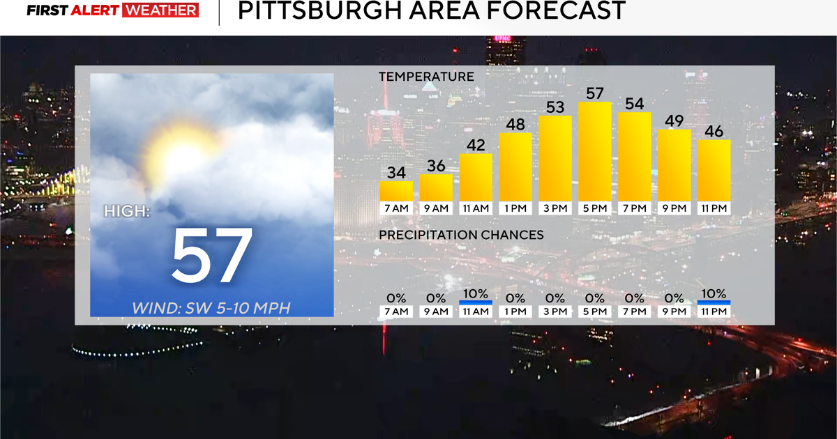
It’s going to be a pleasant day in the Pittsburgh area with high temperatures in the mid-to-upper 50s.
Any Alert Days Ahead? Keeping an eye on Sunday. Also, stormy condition are expected on Friday morning.
Aware: Dense fog advisory in place for places in Ohio this morning
Today is looking dry and warm with highs hitting the mid to upper 50s. I have noon temperatures in the mid-40s, with Pittsburgh seeing a high of 57°. Winds will be out of the southwest at about 5mph.
Rain chances return on Wednesday, with the best chance for rain happening during the afternoon. I can’t rule out a rumble or two as the rain moves through.

KDKA Weather Center
Another system kicks through late Thursday into Friday with a higher storm chance happening then. The highest chance for rain on Friday will come before sunrise.
Looking at your weekend, a snow chance is set to arrive on Sunday, with snow and a mix of snow and rain expected through most of the day. Some data is showing upwards of 4 inches of snow, but model data is likely not doing a good job of dividing snow from the mix of rain happening at the same time. We will have more details over the coming days.

KDKA Weather Center
Currently, I have moderate confidence we will all see snow on Sunday, with low confidence on any type of totals.
The impact of global conditions on you
If you’ve been in Pittsburgh or Western Pennsylvania over the past two months, you know that this winter season has been brutal when compared to recent winters. I actually had a couple of ‘keyboard joes’ remind me that supposedly our snow and winter cold weather is proof that global warming is a scam. While I am always amazed that by now the theory of man-induced global heating isn’t more acceptable, it is what it is. This is not going to be a ‘global warming’ blog. However, while doomscrolling last night, I saw a post that made me want to talk about how our atmosphere works.
Oftentimes, we as forecasters don’t get to talk enough about the big global conditions that are in place and how they impact you. While you are going through your everyday life, there is a constant battle of hot and cold going on all around us. This is due to the uneven exchange of solar energy on a surface that, while not perfectly spherical, it’s close. We all know that the equator sees an almost year-long direct angle from the sun, whereas our poles never see a strong sun angle. This means the poles are ‘colder’ than the equator due to the lack of energy being absorbed. This gets even more complicated because our globe rotates, making one ‘warm’ side and another the ‘cool’ side. Our atmosphere is fluid, and the battle of hot and cold takes on the form of ‘waves’. We have short waves that often times brings us our rain days when they weep through. We also have long waves that set up a lot longer and give us our weather patterns. So where am I going with this? Just because the weather here has been ‘colder’ this season doesn’t mean that everyone is seeing that type of weather. What we have seen over the past fifty years is that when it comes to these ‘ long waves’, the warm surge area is wider than it was one hundred years ago. The cold air pushes are more narrow. The reason I wanted to talk about this was that while we have been having a brutally cold (compared to recent years) winter, the other side of the country has been unseasonably warm. Denver, Colorado saw their 35th 60° day this winter yesterday. That’s the most on record for them, and there is still plenty of winter to go. It’s one of many warm-weather records that are falling west of the Mississippi.
WEATHER LINKS:
Current Conditions | School Closings & Delays | Submit Your Weather Photos