Light drizzle and areas of fog are expected to affect the region until mid-morning Tuesday.
The National Weather Service warns of patchy black ice, particularly in higher elevations, as a weak low pressure system moves across the area.
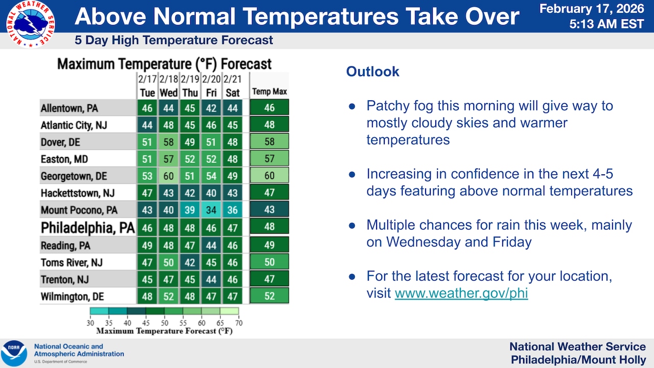
Cloudy conditions are expected to gradually give way to mostly sunny skies Tuesday for the Lehigh Valley, with highs in the mid-40s that are slightly above normal for this time of year. Winds are calm to around 5 mph from the southwest, ahead of increasing cloud cover at night.
Wednesday will bring the first of multiple rain systems moving through the region.
A warm front will lift northward, producing light rain mainly for areas north of Interstate 78, with rainfall amounts between one-tenth and one-quarter inch expected. Higher elevations in the southern Poconos and far northern New Jersey could see locally higher amounts up to one-half inch. South of I-78, precipitation amounts should remain under one-tenth inch.
This system is expected to produce only rain, with no wintry precipitation anticipated.
Following the midweek system, a backdoor cold front will sink southward late Wednesday through Thursday in response to high pressure developing to the north.
This front will likely bisect the area. Temperatures north of the front will reach the upper 40s, while southern areas could see highs in the low to mid-50s. Overnight lows near and north of the front will range from the upper 20s to low 30s, still above normal for mid-February.
Light showers and drizzle are possible Thursday, particularly near and north of the front’s position.
Another low pressure system will arrive Friday into Saturday, bringing another round of rain to most of the area. Given slightly cooler temperatures during this timeframe, there is potential for some mixed precipitation and wintry precipitation in higher elevations of northern New Jersey and the Poconos. Rainfall amounts could reach around an inch in some areas.
Above-normal temperatures will continue through at least the first half of the weekend before potentially dropping to near or below normal levels for the latter half of the weekend and into next week.
The region remains in various levels of drought, making the expected rainfall beneficial.
A more impactful weather system is being monitored for late weekend, though details remain uncertain — with possibilities ranging from significant snowfall to a complete miss of the region.
Current weather radar