
A Dense Fog Advisory is in effect for Lebanon and Schuylkill Counties until 10 a.m. Visibility may drop as low as 1/4 mile. Although other counties aren’t included in the advisory, fog could still be quite dense, and you may encounter mist and drizzle. Watch for reduced visibility through late morning. Code Orange Air Quality Alert: The combination of cold air at the surface and warmer air overhead has led to an inversion in the atmosphere. This traps particle pollutants like wood smoke and car exhaust near the surface. With little wind to mix the atmosphere, pollutant concentrations increase. Children, the elderly, and people with heart and lung conditions may want to limit strenuous activity outdoors today. We’ll see mostly cloudy skies with peeks of sun this afternoon. Highs will be milder, in the upper 40s to near 50 degrees and winds will be light. The best shot of hitting 50 is south of the PA Turnpike. Tonight, lows will fall to the mid-30s under mostly cloudy skies. Areas of dense fog may redevelop. As a warm front moves north Wednesday morning, scattered showers will move through the area in the morning. Highs will hover in the mid-40s, and a few showers are possible later in the day. Clouds and light winds persist Thursday, along with above-average highs in the mid-40s.Early Friday, another wet weather system will move toward the Susquehanna Valley, leading to light rain for the first half of the day. Highs will be cooler, near 42 degrees.Look for partly sunny skies and seasonable temperatures in the 40s Saturday, then a chance of snow showers Sunday into early Monday. Sunday’s highs will fall to the mid-30s. Cold temperatures in the low-to-mid 30s are in store Monday and Tuesday. Add a blustery breeze, and it will feel like the low 20s. Temperatures moderate to the upper 30s Wednesday, then hit the mid-40s Thursday with rain returning.
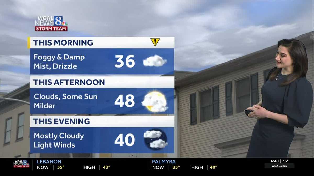
A Dense Fog Advisory is in effect for Lebanon and Schuylkill Counties until 10 a.m. Visibility may drop as low as 1/4 mile.
Although other counties aren’t included in the advisory, fog could still be quite dense, and you may encounter mist and drizzle. Watch for reduced visibility through late morning.
Code Orange Air Quality Alert:
The combination of cold air at the surface and warmer air overhead has led to an inversion in the atmosphere. This traps particle pollutants like wood smoke and car exhaust near the surface. With little wind to mix the atmosphere, pollutant concentrations increase. Children, the elderly, and people with heart and lung conditions may want to limit strenuous activity outdoors today.
We’ll see mostly cloudy skies with peeks of sun this afternoon. Highs will be milder, in the upper 40s to near 50 degrees and winds will be light. The best shot of hitting 50 is south of the PA Turnpike.
Tonight, lows will fall to the mid-30s under mostly cloudy skies. Areas of dense fog may redevelop.
As a warm front moves north Wednesday morning, scattered showers will move through the area in the morning. Highs will hover in the mid-40s, and a few showers are possible later in the day.
Clouds and light winds persist Thursday, along with above-average highs in the mid-40s.
Early Friday, another wet weather system will move toward the Susquehanna Valley, leading to light rain for the first half of the day. Highs will be cooler, near 42 degrees.
Look for partly sunny skies and seasonable temperatures in the 40s Saturday, then a chance of snow showers Sunday into early Monday. Sunday’s highs will fall to the mid-30s.
Cold temperatures in the low-to-mid 30s are in store Monday and Tuesday. Add a blustery breeze, and it will feel like the low 20s.
Temperatures moderate to the upper 30s Wednesday, then hit the mid-40s Thursday with rain returning.