
Mild, Highs Near 50 Today; Couple Chances Of Rain This Week In South Central Pennsylvania
Highs will stay above average over the next few days, but there won’t be much sunshine.
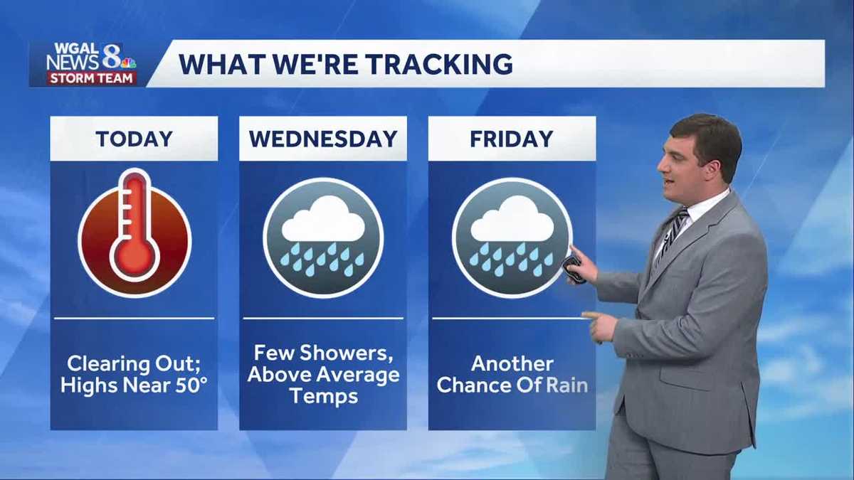
ELEVATIONS COULD GET SEVERAL FEET OF SNOW THROUGH WEDNESDAY. NOW, THE NEWS EIGHT STORM TEAM FORECAST, WITH METEOROLOGIST MIKE SUSKO. GOOD AFTERNOON EVERYONE. WE’RE SEEING THE MILDER SIDE OF THINGS HERE AS WE GO THROUGH THE DAY TODAY. HIGHS GETTING INTO THE MID TO UPPER 40S TO NEAR 50 DEGREES IN OUR SOUTHWESTERN AREAS. AND FOR YOUR WEDNESDAY WE’RE LOOKING AT A FEW RAIN SHOWERS BUT A BETTER CHANCE FOR SOME RAIN AS WE GO INTO FRIDAY HERE LATER INTO THE WEEK, BUT THE REST OF THE WEEK LOOKING LIKE IT’S GOING TO BE AT OR ABOVE AVERAGE, INCLUDING IN LEBANON. RIGHT NOW WE HAVE THE CLOUD COVER IN PLACE. ONE OF THE COOL SPOTS IN OUR AREA IS LEBANON, AND THE REASON WHY IS BECAUSE YOU HAVE A HIGHER CLOUD COVER AT THE MOMENT. 39 IN LEBANON, 38 IN LANCASTER, BUT JUST TO THE WEST, 40 IN HARRISBURG, 41 IN YORK. CHECK OUT GETTYSBURG AT 46. WE ARE GOING TO SEE A COUPLE 50S, I THINK, LATER THIS AFTERNOON IN OUR WESTERN COMMUNITIES, EASTERN COMMUNITIES, IT’S GOING TO BE A LITTLE TOUGH FOR YOU JUST BECAUSE THOSE CLOUDS ARE NOT BUDGING VERY MUCH AT THE MOMENT HERE. AND THAT’S GOING TO HELP KEEP YOU A BIT COOLER AS WE GO THROUGHOUT THE AFTERNOON. BUT WE WILL BE DRY ACROSS THE ENTIRE REGION TODAY. WE’RE JUST GOING TO STAY CLOUDY AND WE’LL GET ABOVE AVERAGE. BUT AGAIN, SOME OF YOU COOLER THAN OTHERS, 48 WILL BE THE HIGH FOR A LARGE PORTION OF THE AREA TODAY WITH THAT MOSTLY CLOUDY SKY TONIGHT, I DO EXPECT MORE FOG TO DEVELOP ACROSS THE AREA SO WE COULD SEE SOME MORE DENSE FOG TOMORROW MORNING. JUST KEEP THAT IN MIND IF YOU’RE GOING TO BE OUT AND ABOUT. WE’RE ALSO WATCHING FOR SOME SHOWERS LATE, ESPECIALLY NORTH OF THE TURNPIKE, AS WE GO TOWARDS SUNRISE TOMORROW. A FEW SHOWERS NORTH OF THE TURNPIKE IN THE MORNING, THEN ANOTHER ROUND OF SHOWERS IN THE AFTERNOON FOR EVERYBODY WITH HIGHS RIGHT AROUND 46 DEGREES. SO LET’S TIME THIS OUT FOR YOU. AS I SAID, THOSE CLOUDS KIND OF HANG TOUGH ACROSS OUR EASTERN COMMUNITIES THIS AFTERNOON. THAT’S GOING TO LIMIT HOW MUCH YOU WARM UP COMPARED TO OUR WESTERN AREAS AS WE GO INTO WEDNESDAY. THERE’S THE SHOWERS IN THE MORNING FOR NORTHERN AND NORTH OF THE TURNPIKE AROUND SIX 7:00 IN THE MORNING. BUT IT’S VERY LIGHT AND MOVES ON OUT. THEN THE REST OF THE MORNING IS DRY AND THE AFTERNOON AROUND TWO 3:00. THAT’S WHEN WE START SEEING SOME MORE SCATTERED SHOWERS POP UP ACROSS THE AREA AS WE HEAD INTO THE EVENING HOURS, AND THEN THE REST OF THE NIGHT SHOULD BE FAIRLY UNEVENTFUL AND QUIET AS WE GO THROUGH YOUR THURSDAY. THURSDAY’S DRY, BUT IT DOES LOOK LIKE WE’RE GOING TO BE A BIT COOLER AS THE COLD FRONT WILL BE JUST TO OUR SOUTH. THAT WILL KEEP ANY OF THAT MILD AIR A LITTLE BIT SOUTH. MORE SOUTH FOR US AS WE GO INTO THURSDAY. THEN AS WE GO INTO YOUR FRIDAY, WE WILL BE WATCHING ANOTHER ROUND OF SHOWERS MOVE IN. DOES LOOK LIKE WE COULD EVEN GET A LITTLE BIT OF MIXING IN THE HIGHER ELEVATIONS, MAYBE NEAR SCHUYLKILL COUNTY FOR EXAMPLE, BUT WE’LL HAVE TO KEEP AN EYE ON THAT. MOST OF US GET JUST A COLD, PLAIN RAIN WITH THIS AS IT COMES IN ON FRIDAY, AND THEN MOVES OUT BY THE TIME WE GET TO SATURDAY. BUT AS WE GO INTO THE WEEKEND, WE ARE WATCHING THE POTENTIAL FOR A COASTAL STORM TO DEVELOP. THERE IS A LOT OF UNCERTAINTY WITH THIS. THIS IS THE EUROPEAN MODEL. THIS ONE IS KEEPING THE STORM WELL TO THE SOUTH AND OUT OF THE SUSQUEHANNA VALLEY. BUT THE AMERICAN MODEL IS BRINGING IT CLOSER AND YOU CAN SEE WIDESPREAD SNOW. NOW THIS IS JUST TWO MODELS OUT OF DOZENS THAT WE LOOK AT. SO WHEN WE TAKE ALL THOSE MODELS AND SAY, OKAY, WHAT’S OUR CHANCE RIGHT NOW. LOOKS LIKE A MEDIUM CHANCE ACROSS OUR AREA SUNDAY INTO EARLY MONDAY, WHERE WE ARE LOOKING AT SOME SORT OF MEASURABLE SNOWFALL THAT RANGES WILL VARY VERY HIGHLY ACROSS THE AREA HERE, ESPECIALLY THIS FAR OUT HERE. SO IN TERMS OF CONFIDENCE, THE TIMING DOES LOOK LIKE IT’S THE SECOND HALF OF THE WEEKEND, BUT EVERYTHING ELSE RIGHT NOW IS JUST TOO FAR OUT AT THIS POINT TO FOR CERTAIN DETAILS. SO WE’LL KEEP AN EYE ON THAT AND KEEP AN EYE. I’LL LET YOU KNOW OF ANY CHANGES. YOUR TEN DAY FORECAST THE REST OF THE WEEK IT WILL BE AT OR ABOVE AVERAGE. WE HAVE THOSE SHOWER CHANCES TOMORROW. BETTER CHANCE FOR FRIDAY AND THEN YOU CAN SEE THE SNOW SHOWER CHANCE ON SUNDAY.
Mild, Highs Near 50 Today; Couple Chances Of Rain This Week In South Central Pennsylvania
Highs will stay above average over the next few days, but there won’t be much sunshine.

Updated: 1:09 PM EST Feb 17, 2026
Good afternoon!Code Orange Air Quality Alert:The combination of cold air at the surface and warmer air overhead has led to an inversion in the atmosphere. This traps particle pollutants like wood smoke and car exhaust near the surface. With little wind to mix the atmosphere, pollutant concentrations increase. Children, the elderly, and people with heart and lung conditions may want to limit strenuous activity outdoors today.We’ll see mostly cloudy skies with peeks of sun this afternoon. Highs will be milder, in the upper 40s to near 50 degrees, and winds will be light. The best shot of hitting 50 is south of the PA Turnpike and west of the Susquehanna River.Tonight, lows will fall to the mid-30s under mostly cloudy skies. Areas of dense fog may redevelop.As a warm front moves north on Wednesday morning, scattered showers will move through the area around sunrise. Highs will hover in the mid-40s, and a few showers are possible later in the day.Clouds and light winds persist on Thursday, along with above-average highs in the mid-40s.Early Friday, another wet weather system will move toward the Susquehanna Valley, leading to light rain for the first half of the day. Highs will be cooler, near 42 degrees.Look for partly sunny skies and seasonable temperatures in the 40s on Saturday, then a chance of snow showers Sunday into early Monday. Some models are showing the potential for an impactful storm system in the Susquehanna Valley. However, models are very inconsistent at this time, and there are many factors that will influence the forecast. Be sure to stay tuned for more updates as we get closer to the event. Sunday’s highs will fall to the mid-30s. Cold temperatures in the low-to-mid 30s are in store for Monday and Tuesday. Add a blustery breeze, and it will feel like the low 20s.Temperatures moderate to the upper 30s on Wednesday, then hit the mid-40s on Thursday with rain returning.Have a great day!
Good afternoon!
Code Orange Air Quality Alert:
The combination of cold air at the surface and warmer air overhead has led to an inversion in the atmosphere. This traps particle pollutants like wood smoke and car exhaust near the surface. With little wind to mix the atmosphere, pollutant concentrations increase. Children, the elderly, and people with heart and lung conditions may want to limit strenuous activity outdoors today.
We’ll see mostly cloudy skies with peeks of sun this afternoon. Highs will be milder, in the upper 40s to near 50 degrees, and winds will be light. The best shot of hitting 50 is south of the PA Turnpike and west of the Susquehanna River.
Tonight, lows will fall to the mid-30s under mostly cloudy skies. Areas of dense fog may redevelop.
As a warm front moves north on Wednesday morning, scattered showers will move through the area around sunrise. Highs will hover in the mid-40s, and a few showers are possible later in the day.
Clouds and light winds persist on Thursday, along with above-average highs in the mid-40s.
Early Friday, another wet weather system will move toward the Susquehanna Valley, leading to light rain for the first half of the day. Highs will be cooler, near 42 degrees.
Look for partly sunny skies and seasonable temperatures in the 40s on Saturday, then a chance of snow showers Sunday into early Monday. Some models are showing the potential for an impactful storm system in the Susquehanna Valley. However, models are very inconsistent at this time, and there are many factors that will influence the forecast. Be sure to stay tuned for more updates as we get closer to the event.
Sunday’s highs will fall to the mid-30s. Cold temperatures in the low-to-mid 30s are in store for Monday and Tuesday. Add a blustery breeze, and it will feel like the low 20s.
Temperatures moderate to the upper 30s on Wednesday, then hit the mid-40s on Thursday with rain returning.
Have a great day!