
Good evening, Code Orange Air Quality Alert Tuesday & Wednesday:The combination of cold air at the surface and warmer air overhead has led to an inversion in the atmosphere. This traps particle pollutants like wood smoke and car exhaust near the surface. With little wind to mix the atmosphere, pollutant concentrations increase. Children, the elderly, and people with heart and lung conditions may want to limit strenuous activity outdoors this evening and Wednesday.We will continue to see a partly to mostly cloudy sky across the Susquehanna Valley this evening with overnight lows falling to the mid-30s under mostly cloudy skies. Areas of dense fog may develop with widespread visibility less than 1/2 mile expected.As a warm front moves north on Wednesday morning, scattered showers will move through the area around sunrise, mainly north of the PA Turnpike. Highs will hover in the mid-40s, and a few showers are possible again later in the day.Clouds and light winds persist on Thursday, along with above-average highs in the mid-40s.Early Friday, another wet weather system will move toward the Susquehanna Valley, leading to light rain for the first half of the day. Highs will be cooler, near 42 degrees.Look for partly sunny skies and seasonable temperatures in the 40s on Saturday. Sunday’s highs will drop to the upper 30s as a coastal storm develops off the East Coast.The latest weather model trends have shown an increase in the likelihood of an impactful storm on Sunday in the Susquehanna Valley. However, forecasting guidance is inconsistent at this time, and there are many factors that will influence the forecast, including snowfall totals and impacts. Be sure to stay tuned for more updates as we get closer to the event.Cold temperatures in the low-to-mid 30s are in store for Monday and Tuesday. Add a blustery breeze, and it will feel like the low 20s.Temperatures moderate to the upper 30s on Wednesday, then hit the mid-40s on Thursday with rain returning.Have a great day!
Good evening,
Code Orange Air Quality Alert Tuesday & Wednesday:
The combination of cold air at the surface and warmer air overhead has led to an inversion in the atmosphere. This traps particle pollutants like wood smoke and car exhaust near the surface. With little wind to mix the atmosphere, pollutant concentrations increase. Children, the elderly, and people with heart and lung conditions may want to limit strenuous activity outdoors this evening and Wednesday.
We will continue to see a partly to mostly cloudy sky across the Susquehanna Valley this evening with overnight lows falling to the mid-30s under mostly cloudy skies. Areas of dense fog may develop with widespread visibility less than 1/2 mile expected.
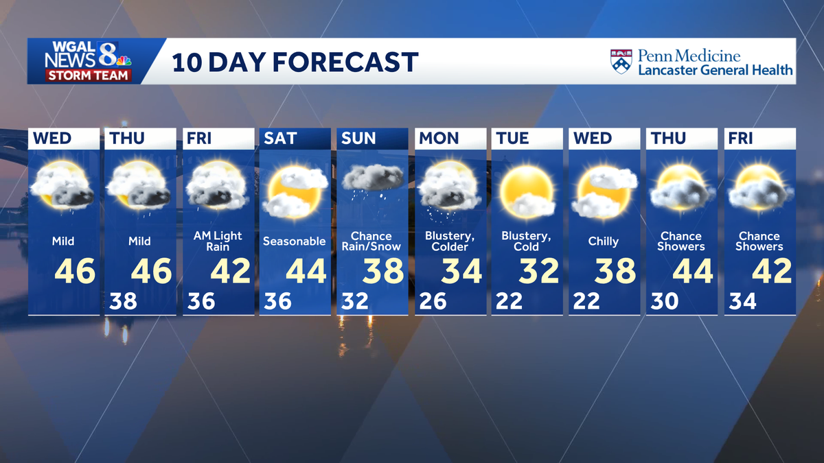
As a warm front moves north on Wednesday morning, scattered showers will move through the area around sunrise, mainly north of the PA Turnpike. Highs will hover in the mid-40s, and a few showers are possible again later in the day.
Clouds and light winds persist on Thursday, along with above-average highs in the mid-40s.
Early Friday, another wet weather system will move toward the Susquehanna Valley, leading to light rain for the first half of the day. Highs will be cooler, near 42 degrees.
Look for partly sunny skies and seasonable temperatures in the 40s on Saturday. Sunday’s highs will drop to the upper 30s as a coastal storm develops off the East Coast.
The latest weather model trends have shown an increase in the likelihood of an impactful storm on Sunday in the Susquehanna Valley. However, forecasting guidance is inconsistent at this time, and there are many factors that will influence the forecast, including snowfall totals and impacts. Be sure to stay tuned for more updates as we get closer to the event.
Cold temperatures in the low-to-mid 30s are in store for Monday and Tuesday. Add a blustery breeze, and it will feel like the low 20s.
Temperatures moderate to the upper 30s on Wednesday, then hit the mid-40s on Thursday with rain returning.
Have a great day!