
Chance for accumulating snow this weekend | Still too early to tell timing, totals
NOW THE WGAL NEWS EIGHT STORM TEAM FORECAST WITH METEOROLOGIST ETHAN HUSTON. IT’S BEEN A MILD DAY OUT THERE ACROSS THE SUSQUEHANNA VALLEY. SOME AREAS SEEING TEMPERATURES ALL THE WAY UP INTO THE 50S THIS AFTERNOON. SOME AREAS STAYING IN THE 30S. AND IT’S BECAUSE OF THAT LINGERING SNOWPACK IN THE FOG THAT WE HAD THIS MORNING. WE’LL HAVE THE RETURN OF SOME FOG LATER TONIGHT. SO THAT’S WHY TONIGHT’S AN IMPACT NIGHT, AS THAT FOG COULD BE DENSE, ESPECIALLY AS WE GET CLOSER TO DAWN TOMORROW. NEXT FEW DAYS. LOOKS LIKE THEY’RE GOING TO BE SEASONALLY MILD BUT ACTIVE ROUNDS OF SHOWERS ARE LIKELY ACROSS THE VALLEY AND THEN HEADING INTO THE WEEKEND. CONFIDENCE IS GROWING THAT WE HAVE A DECENT POTENTIAL FOR A WINTER STORM. MORE ON THAT IN JUST A MOMENT. TAKING A LIVE LOOK RIGHT NOW OVER LEBANON. IT IS TRANQUIL OUT THERE AND IT IS MILD. WE’RE AT 46 DEGREES. WINDS ARE CALM. STILL HAVE THAT HAZE ON THE HORIZON BECAUSE OF THE HIGH POLLUTION CONCENTRATION, LEADING TO AN AIR QUALITY ALERT TODAY AND ALSO FOR TOMORROW. NOTICE VISIBILITY DOWN TO THREE MILES IN REDDING. STILL FIVE MILES IN LANCASTER. BUT I DO EXPECT THAT DENSE FOG WILL BE OUT THERE THROUGH THE NIGHT TONIGHT. WIDESPREAD VISIBILITY, POSSIBLY ABOUT A HALF A MILE OR LESS, AND THERE COULD BE SOME SPOTS THAT’S CLOSE TO ZERO. SO JUST BE PREPARED FOR THAT THROUGH THE NIGHT, TONIGHT AND TOMORROW MORNING. FOR THIS EVENING, THOUGH, THE FALL WILL START DEVELOPING AS THE CLOUDS THICKEN UP. AND I DO EXPECT TEMPERATURES BECOME A BIT MORE UNIFORM IN THE UPPER 30S TO LOWER 40S. LOWS TONIGHT WILL BE WARMER THAN AVERAGE. WE’RE ONLY GOING TO DIP DOWN TO THE MID TO UPPER 30S. THEN FOR TOMORROW I DO EXPECT SOME SHOWERS AT TIMES AND TEMPERATURES WILL CLIMB INTO THE 40S. OUT THERE ACROSS THE SUSQUEHANNA VALLEY. A FEW SPOTS WILL BE CLOSER TO 50 DEGREES, BUT UNFORTUNATELY, ONCE AGAIN ANOTHER AIR QUALITY ALERT AS THE WE HAVE THE WARMER AIR SITTING OVER THAT SNOW PACK. SO POLLUTION CONCENTRATIONS REMAIN QUITE HIGH AT THE SURFACE. MADE IT TO 47 OUT AT THE AIRPORT. START THE DAY OFF AT 34 AND LOOK AT THE SNOW DEPTH. NOW DOWN TO JUST AN INCH. BUT LOOK AT THE TEMPERATURES SPREAD ACROSS THE REGION. CHAMBERSBURG YOU’RE AT 51 DEGREES, BUT JUST 38 RIGHT NOW IN LANCASTER, 40 TO 45 CURRENTLY IT’S EVEN WARMER OFF TO THE WEST, CLOSE TO 60 RIGHT NOW IN MORGANTOWN AND 57 IN PITTSBURGH. SO THERE’S THE INCOMING SYSTEM. YOU CAN SEE LEADING EDGE OF THE CLOUDS STARTING TO MOVE INTO OUR WESTERN COMMUNITIES. AND AS WE GO THROUGH THE NIGHT TONIGHT MAY GET CLIPPED BY A STRAY SHOWER FOR NORTHERN COMMUNITIES. BUT THE BEST CHANCE FOR THESE SPOTTY SHOWERS WILL BE OUT THERE FIRST THING IN THE MORNING WITH SOME OF THAT FOG. AND THEN AS WE GO THROUGH THE AFTERNOON, WE COULD SEE SOME HIT OR MISS LIGHT RAIN SHOWERS, AND SOME OF THOSE WILL LINGER INTO THE EARLY EVENING HOURS BEFORE A COLD FRONT MOVES ON BY. MOST OF THURSDAY LOOKS DRY. IT’S ONCE WE GET PAST SUNSET, THIS FRONTAL BOUNDARY STARTS TO APPROACH THE REGION AND RAIN CHANCES WILL START TO GO UP AGAIN. SO WHERE ARE THE STORMS RIGHT NOW? HERE’S STORM NUMBER ONE. HERE’S STORM NUMBER TWO, AND THERE’S STORM NUMBER THREE. AND THAT’S THE ONE THAT A LOT OF PEOPLE HAVE THEIR ATTENTION ON FOR SUNDAY, AS IT IS GOING TO BE MOVING OUT IN THE OPEN WATERS, THEN STARTING TO MOVE INLAND AND THEN STARTING TO TURN OUR ATTENTION TO THE COAST. DOES THIS SOUND FAMILIAR? LIKELY HAS BEEN OR HAS BEEN OUR STORM TRACKS FOR A NUMBER OF THE PAST WEEKEND. SO RIGHT NOW, CONFIDENCE IS INCREASING. IT’S MEDIUM CHANCE THAT WE’LL HAVE A WINTER STORM OFF THE EAST COAST, BUT THE SPECIFIC TRACK INTENSITY IMPACTS THAT IS STILL YET TO BE DETERMINED. BUT HERE’S WHAT I CAN TELL YOU WITH HIGH CONFIDENCE AT THIS TIME. AND IN TERMS OF WHAT YOU NEED TO KNOW, NOTICE AS WE GO PAST SUNSET, LOOKING LIKE A GOOD CHANCE THAT WE’RE GOING TO BE CONTENDING WITH SOME SNOW. SO COMING IN ON SUNDAY, OUT THERE ON MONDAY. BUT IN TERMS OF THE TEMPERATURES, I EXPECT TEMPERATURES TO BE ABOVE FREEZING. SO IF WE DO SEE SNOW, THAT WILL LIKELY CUT DOWN ON THE TOTALS. AND YOU CAN SEE THAT RAIN SNOW MIX LINE, THAT HAS BEEN A PROBLEM WITH US ALL WINTER LONG WITH OUR WINTER STORMS. THAT IS YET TO BE DETERMINED AS WELL. SO IN TERMS OF THE EXACT DETAILS, WITH THIS STORM STILL TOO FAR OUT IN THE FUTURE, BUT I DO WANT YOU TO CONTINUE TO STAY UPDATED AND STAY WITH US AS CONFIDENCE CONTINUES TO INCREASE, WE’RE GOING TO BE DEALING WITH SOMETHING ON SUNDAY. NOW, ONCE WE GET PAST SUNDAY COULD BE SOME LINGERING LIGHT SNOW ON INTO MONDAY MORNING. AND NOTICE THAT CHILL IS BACK. WE’RE TALKING HIGHS BACK DOWN CLOSER TO FREEZING. TEMPERATURES WILL THEN START TO CLIMB AGAIN. BA
Chance for accumulating snow this weekend | Still too early to tell timing, totals

Updated: 8:43 PM EST Feb 17, 2026
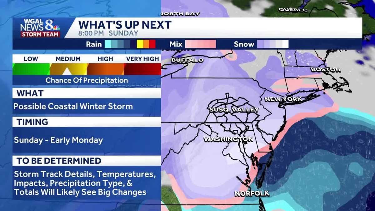
A potential coastal winter storm could bring snow to South-Central Pennsylvania this weekend, with a medium chance of accumulating snow in the Susquehanna Valley. However, timing and totals are still uncertain because the storm is still five to seven days out.What to expectPossible coastal storm bringing snow to parts of South-Central Pennsylvania over the weekend.Medium probability of accumulating snow in the Susquehanna Valley; other areas may see light snow or rain/snow mix depending on track.Some models and apps are showing very high snow totals, but those numbers are premature this far out.Winter storm timingWindow: weekend (roughly Sunday – early Monday); exact timing will depend on the storm track.Forecast confidence is low at 5–7 days lead time — details could change with each model run.Uncertainty and forecast confidenceModels are inconsistent right now, which is normal this far ahead.Small shifts in the coastal storm track or timing will greatly affect who sees heavy snow versus light snow or rain, or if parts of region stay dry. What you should doDon’t rely on high snowfall totals shown by some apps yet — treat them as early guidance only.Monitor updates over the next 48–72 hours as confidence and model agreement improve.Prepare to adjust plans if official forecasts tighten up closer to the weekend.Short-term outlookEnjoy milder temperatures this week — the warmest we’ve had in over a month — while keeping an eye on weekend model trends.SOUTH-CENTRAL PA WEATHER RESOURCES: INTERACTIVE RADAR | ACTIVE WEATHER ALERTS | CURRENT CONDITIONS | HOURLY FORECAST | 10-DAY FORECAST | WEEKEND FORECAST | MAP ROOM | DOWNLOAD THE APP | WEATHER EMAILS
A potential coastal winter storm could bring snow to South-Central Pennsylvania this weekend, with a medium chance of accumulating snow in the Susquehanna Valley. However, timing and totals are still uncertain because the storm is still five to seven days out.

What to expectPossible coastal storm bringing snow to parts of South-Central Pennsylvania over the weekend.Medium probability of accumulating snow in the Susquehanna Valley; other areas may see light snow or rain/snow mix depending on track.Some models and apps are showing very high snow totals, but those numbers are premature this far out.

Winter storm timing
Window: weekend (roughly Sunday – early Monday); exact timing will depend on the storm track.Forecast confidence is low at 5–7 days lead time — details could change with each model run.

Uncertainty and forecast confidenceModels are inconsistent right now, which is normal this far ahead.Small shifts in the coastal storm track or timing will greatly affect who sees heavy snow versus light snow or rain, or if parts of region stay dry.

What you should doDon’t rely on high snowfall totals shown by some apps yet — treat them as early guidance only.Monitor updates over the next 48–72 hours as confidence and model agreement improve.Prepare to adjust plans if official forecasts tighten up closer to the weekend.

Short-term outlookEnjoy milder temperatures this week — the warmest we’ve had in over a month — while keeping an eye on weekend model trends.
SOUTH-CENTRAL PA WEATHER RESOURCES: INTERACTIVE RADAR | ACTIVE WEATHER ALERTS | CURRENT CONDITIONS | HOURLY FORECAST | 10-DAY FORECAST | WEEKEND FORECAST | MAP ROOM | DOWNLOAD THE APP | WEATHER EMAILS