
Code orange air quality alert in effect for most of south-central Pennsylvania
METEOROLOGIST CHRISTINE FERREIRA. HERE WE GO AGAIN. WITH THAT FOG, THERE IS A DENSE FOG ADVISORY IN EFFECT FOR YORK AND LANCASTER COUNTIES THAT GOES UNTIL 10 A.M. THERE IS STILL FOG ELSEWHERE, SO YOU MIGHT ENCOUNTER VISIBILITY DOWN TO AS LOW AS A QUARTER OF A MILE IN SOME SPOTS. PLEASE USE CAUTION AND WATCH FOR CHANGING VISIBILITY ON YOUR MORNING DRIVE. IN ADDITION, WE HAVE ANOTHER AIR QUALITY ALERT TODAY. SAME REASONING. WE HAVE THAT DENSE COLD AIR AT THE SURFACE, WARMER AIR JUST ABOVE OUR HEADS. SO THAT CREATES A LID ON THE ATMOSPHERE AND TRAPS PARTICLE POLLUTANTS RIGHT NEAR THE SURFACE. SO UNHEALTHY FOR SENSITIVE GROUPS, CHILDREN, THE ELDERLY, FOLKS WITH HEART OR LUNG CONDITIONS MIGHT WANT TO LIMIT YOUR STRENUOUS ACTIVITY OUTDOORS. HERE’S OUR NEWS EIGHT STORM TEAM FORECAST TODAY. WATCH OUT FOR THAT FOG THIS MORNING. COUPLE OF SHOWERS OUT THERE AND THERE COULD BE A FEW ADDITIONAL SHOWERS LATER. WE’LL SEE. CLOUDY SKIES. HIGHS IN THE LOWER 40S. TONIGHT MOSTLY CLOUDY. AREAS OF FOG. REDEVELOP. THAT’S A BROKEN RECORD FORECAST AND TEMPERATURES WILL FALL TO THE MID 30S TOMORROW. MAINLY CLOUDY SKIES, SEASONABLE HIGHS IN THE LOWER 40S. I DO SEE SHOWERS LATE TOMORROW EVENING INTO TOMORROW NIGHT. AND THAT IS GOING TO BE OUR BEST CHANCE OF RAIN WE’VE SEEN IN A WHILE. COULD BE EVEN MODERATE TO BRIEFLY HEAVY AT TIMES. OVERNIGHT THURSDAY NIGHT INTO EARLY FRIDAY MORNING. I’LL SHOW YOU THAT COMING UP. ALMANAC. YESTERDAY WE DIDN’T MAKE IT TO 50 IN HARRISBURG, BUT IT WAS CLOSE. IT WAS 47 DEGREES, AVERAGE BEING 42. AVERAGE LOW 25. WE ARE ABOVE THAT THIS MORNING AND WE ARE NEAR OR ABOVE FREEZING ACROSS MUCH OF THE AREA. 32, IN SELINSGROVE IS ONE OF OUR COOLER SPOTS. 33 IN HARRISBURG, 33 FOR LANCASTER AND 34 IN YORK. JUST A COUPLE OF SPRINKLES OR SPOTTY SHOWERS NOW MOVING FROM DAUPHIN TO LEBANON TO LANCASTER COUNTY. ALL OF THIS IS WITH THE WARM FRONT, WHICH IS LIFTING THROUGH PENNSYLVANIA. BEHIND THAT WARM FRONT, A COUPLE OF TRAILING SHOWERS FOR US LATER TODAY, BUT NOT A SUBSTANTIAL CHANCE OF RAIN. NOT JUST YET, ANYWAY. SO HERE’S THE PREDICTOR SHOWING THE CLOUDS. THEY HANG TOUGH TODAY. I DON’T THINK WE SEE MUCH SUNSHINE. COULD SEE A FEW PEEKS OF CLEARING AS WE HEAD TOWARD EVENING, BUT THE CLOUDS QUICKLY RACE BACK IN OVERNIGHT. TOMORROW THERE COULD BE A SPRINKLE AROUND EARLY. THERE’S A BOUNDARY OVERHEAD AND THAT JUST KIND OF HOVERS AND SINKS TO THE SOUTH LATER IN THE DAY, KEEPING THE CLOUDS AROUND AND KEEPING OUR TEMPERATURES A COUPLE OF DEGREES COOLER. HERE COMES ANOTHER WARM FRONT. THIS IS EARLY FRIDAY. I’M STOPPING THE CLOCK FOR YOU AROUND 1:02 A.M. ON FRIDAY MORNING. AND LOOK AT THAT. WE COULD HAVE SOME MODERATE TO BRIEFLY HEAVY RAINFALL. WE’LL HAVE TO KEEP A WATCHFUL EYE ON OUR RIVERS OR STREAMS OR CREEKS, AS MANY OF THOSE ARE STILL ICE COVERED. AND THE GROUND, OF COURSE, STILL SNOW COVERED IN MANY SPOTS. SO WE’LL HAVE TO WATCH FOR RUNOFF BECAUSE OF THAT RAIN. AS WE GET INTO FRIDAY MORNING. IT’S OUT OF HERE IN JUST A FEW TRAILING SHOWERS LATER IN THE DAY. HERE’S A LOOK AT THE PREDICTOR. ESTIMATED RAINFALL TOTALS FROM THAT RAIN. THAT’S MAINLY GOING TO BE COMING IN THURSDAY NIGHT INTO FRIDAY MORNING, AND MOST SPOTS COULD PICK UP AROUND A HALF INCH TO AN INCH OF RAIN. LET’S TALK ABOUT THE WEEKEND. WE’VE BEEN FOLLOWING THE MODEL COMPARISONS FOR SUNDAY. WILL THERE OR WON’T THERE BE A STORM THAT AFFECTS US IN THE SUSQUEHANNA VALLEY? WELL, THE STORM TRACK IS DEFINITELY GOING TO BE OFFSHORE. THERE WILL BE AN AREA OF LOW PRESSURE OFFSHORE FOR SURE, BUT DOES IT GIVE US A RAIN-SNOW MIX LIKE THIS MODEL IS INDICATING ON SUNDAY AND THEN MAYBE ENDING AS SOME LIGHT SNOW EARLY ON MONDAY? OR DOES THE LOW COME A LITTLE CLOSER AND GIVE US A SLIGHTLY BETTER CHANCE FOR SEEING SOME SNOW LATE SUNDAY INTO MONDAY? THAT’S THE BIG QUESTION, AND THESE DETAILS WILL BE NAILED DOWN OVER THE UPCOMING DAYS. SO WE’RE CONFIDENT THAT THERE’S A THE TIMING IS GOING TO BE SUNDAY INTO MONDAY MORNING. THE STORM TRACK OF MODERATE CONFIDENCE ON THAT OFFSHORE FOR SURE. BUT HOW MUCH SNOW DOES IT BRING US. TOTALS LOW ON MIXED LINE IS LOW ON THAT TOO. DEPENDING TRYING TO PIN DOWN I SHOULD SAY, WHERE THE RAIN AND SNOW ENDS UP. HERE’S A LOOK AT OUR TEN DAY FORECAST. WE DO HAVE THAT CHANCE OF RAIN SNOW ON SUNDAY, WRAPPING UP EARLY MONDAY. LOOK AT MONDAY AND TUESDAY. KIND OF CHILLY TO START THE WEEK, ESPECIALLY WITH THE WIND. BUT THE COLD DOESN’T LAST LONG. WE’RE RIGHT BACK TO AVERAGE IF NOT ABOVE AVERAGE BY THE END OF
Code orange air quality alert in effect for most of south-central Pennsylvania

Updated: 6:02 AM EST Feb 18, 2026
The Pennsylvania Department of Environmental Protection issued a code orange air quality alert for parts of the Susquehanna Valley. The alert is in effect for Wednesday for the following counties:Cumberland CountyDauphin CountyLancaster CountyLebanon CountyYork CountyWhat ‘Code Orange’ meansAir pollution levels may be unhealthy for sensitive groups, including:ChildrenOlder adultsPeople with asthmaPeople with heart disease or other lung diseasesFine particle pollution levels increaseAccording to the Pennsylvania Department of Environmental Protection, fine particle pollution levels increased overnight and will continue to rise during the day today.The WGAL News 8 Storm Team explains that cold, dense air lies near the ground while warmer air sits above, creating an inversion that acts like a “lid” on the atmosphere. This traps particle pollutants like wood smoke and car exhaust near the surface. With little wind to mix the atmosphere, pollutant concentrations increase. Safety precautionsLimit strenuous outdoor activity. Reduce outdoor exercise. Sensitive groups should monitor how long spent outdoors and take breaks as needed. Click here to check your local air quality. SOUTH-CENTRAL PA WEATHER RESOURCES: INTERACTIVE RADAR | ACTIVE WEATHER ALERTS | CURRENT CONDITIONS | HOURLY FORECAST | 10-DAY FORECAST | WEEKEND FORECAST | MAP ROOM | DOWNLOAD THE APP | WEATHER EMAILS
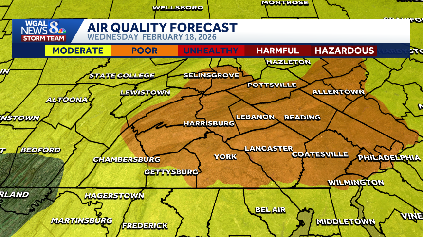
The Pennsylvania Department of Environmental Protection issued a code orange air quality alert for parts of the Susquehanna Valley.
The alert is in effect for Wednesday for the following counties:
Cumberland CountyDauphin CountyLancaster CountyLebanon CountyYork County

What ‘Code Orange’ means
Air pollution levels may be unhealthy for sensitive groups, including:
ChildrenOlder adultsPeople with asthmaPeople with heart disease or other lung diseases

Fine particle pollution levels increase
According to the Pennsylvania Department of Environmental Protection, fine particle pollution levels increased overnight and will continue to rise during the day today.
The WGAL News 8 Storm Team explains that cold, dense air lies near the ground while warmer air sits above, creating an inversion that acts like a “lid” on the atmosphere. This traps particle pollutants like wood smoke and car exhaust near the surface. With little wind to mix the atmosphere, pollutant concentrations increase.
Safety precautionsLimit strenuous outdoor activity. Reduce outdoor exercise. Sensitive groups should monitor how long spent outdoors and take breaks as needed.
Click here to check your local air quality.
SOUTH-CENTRAL PA WEATHER RESOURCES: INTERACTIVE RADAR | ACTIVE WEATHER ALERTS | CURRENT CONDITIONS | HOURLY FORECAST | 10-DAY FORECAST | WEEKEND FORECAST | MAP ROOM | DOWNLOAD THE APP | WEATHER EMAILS