
The WGAL News 8 Storm Team is tracking a winter storm that could impact the Susquehanna Valley this weekend. The storm track is offshore, but the key question is whether it could still bring snow or a wintry mix to south-central Pennsylvania. Forecast models are showing different outcomes. Comparing modelsEuropean Model: Shows a rain and snow mix that ends in light snow Sunday night into early Monday. American Model: Shows a better chance for snow on Sunday, but the bulk of the storm stays offshore. Forecast confidenceTiming — Moderate: Sunday into Monday morningStorm Track — Moderate: Offshore, but how far west does the snow reach?Totals and mix line — Low: Still too early to predict this far out. What you should doDon’t rely on snowfall totals shown by some apps yet; they often have little to no human forecaster input. Monitor updates over the next 48 to 72 hours as confidence and model agreement improve. Be ready to adjust plans if official forecasts become more focused as the weekend gets closer. The WGAL News 8 Storm Team is closely monitoring the winter storm and will share updates as new data becomes available.SOUTH-CENTRAL PA WEATHER RESOURCES: INTERACTIVE RADAR | ACTIVE WEATHER ALERTS | CURRENT CONDITIONS | HOURLY FORECAST | 10-DAY FORECAST | WEEKEND FORECAST | MAP ROOM | DOWNLOAD THE APP | WEATHER EMAILS
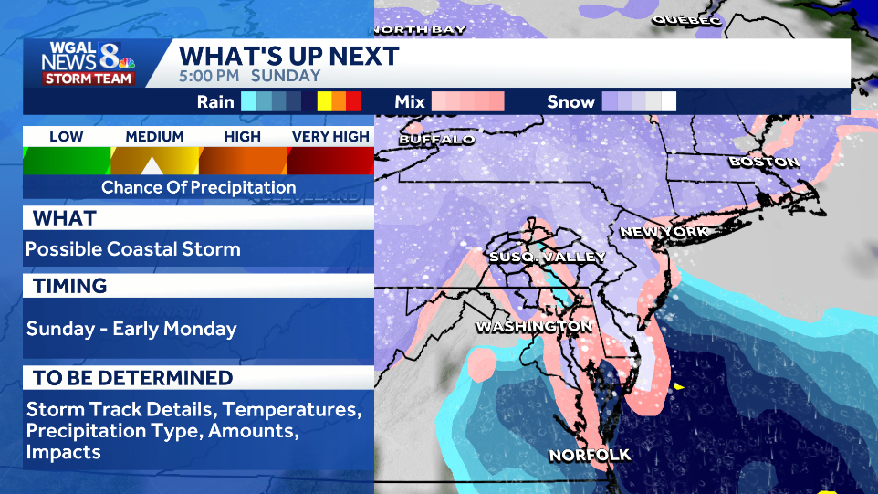
The WGAL News 8 Storm Team is tracking a winter storm that could impact the Susquehanna Valley this weekend.
The storm track is offshore, but the key question is whether it could still bring snow or a wintry mix to south-central Pennsylvania. Forecast models are showing different outcomes.

Comparing models
European Model: Shows a rain and snow mix that ends in light snow Sunday night into early Monday.

American Model: Shows a better chance for snow on Sunday, but the bulk of the storm stays offshore.

Forecast confidence
Timing — Moderate: Sunday into Monday morning
Storm Track — Moderate: Offshore, but how far west does the snow reach?
Totals and mix line — Low: Still too early to predict this far out.

What you should doDon’t rely on snowfall totals shown by some apps yet; they often have little to no human forecaster input. Monitor updates over the next 48 to 72 hours as confidence and model agreement improve. Be ready to adjust plans if official forecasts become more focused as the weekend gets closer.

The WGAL News 8 Storm Team is closely monitoring the winter storm and will share updates as new data becomes available.
SOUTH-CENTRAL PA WEATHER RESOURCES: INTERACTIVE RADAR | ACTIVE WEATHER ALERTS | CURRENT CONDITIONS | HOURLY FORECAST | 10-DAY FORECAST | WEEKEND FORECAST | MAP ROOM | DOWNLOAD THE APP | WEATHER EMAILS