
Late weekend winter storm for western Pennsylvania? Pittsburgh area on fringe of snow
The latest forecast analysis from the Pittsburgh’s Action Weather team.
COMMUTE. THE WARMING TREND CONTINUES. WE WILL HAVE SOME HEAVIER RAIN THOUGH AS WE GET INTO EARLY FRIDAY. AGAIN, WE EXPECT TO SEE THAT LATE THURSDAY NIGHT INTO EARLY FRIDAY MORNING. COULD EVEN HAVE A FEW RUMBLES OF THUNDER. SO OVERALL WE HAVE UPGRADED FRIDAY, ESPECIALLY IN THE MORNING HOURS, TO AN IMPACT DAY. RIGHT NOW THOUGH, SOME LIGHT RAIN SHOWERS CONTINUING TO MOVE OUT AND DRY UP A BIT THERE INTO LAWRENCE, BUT STILL SOME STEADIER LIGHT RAIN INTO NORTHERN BUTLER TAKING OVER INTO MERCER, VENANGO AND CLARION. AND ALSO SEEING THAT INTO NORTHERN PORTIONS OF ARMSTRONG COUNTY. OTHERWISE, MOST OF US JUST HAVE THE CLOUD COVER RELATIVELY QUIET. BEAUTIFUL SHOT HERE OF OUR CITY ON THIS WEDNESDAY MORNING, 42 DEGREES AS YOU WAKE UP IN PITTSBURGH, 38 RIGHT NOW IN BUTLER, BEAVER SITTING AT 3639 IN GREENSBURG AND INDIANA, 45, IN WASHINGTON. UNIONTOWN SITTING AT 40 DEGREES. SO WE’LL GET BREEZY TODAY. THOSE WINDS WILL BE GUSTING INTO THE MID 20S. AND THOSE RAIN SHOWERS STARTING LATE MORNING INTO THE EARLY AFTERNOON. AGAIN, WE DO HAVE THAT IMPACT DAY EARLY FRIDAY WITH SOME OF THE HEAVIER RAIN. TEMPERATURES DROP OFF A BIT HEADING INTO THE WEEKEND AND INTO NEXT WEEK. AND YES, WE DO HAVE SOME SNOW CHANCES COMING IN. NOT A WHOLE LOT OF SNOW, BUT AS WE GET INTO SUNDAY WE COULD SEE SOME OF THOSE FLAKES FLYING AROUND. LET’S TIME IT ALL OUT HERE AS WE CONTINUE THROUGH THE MORNING. LOOKS GREAT FOR THE MORNING COMMUTE, AND THEN WE’LL START TO SEE SOME OF THIS RAIN. TEN 11:00 COULD HAVE SOME POCKETS OF HEAVY RAIN EMBEDDED PASSING NORTH OF THE CITY OF PITTSBURGH INTO THE EARLY AFTERNOON, BUT EXPECTING TO DRY OUT FOR THE EVENING COMMUTE. SO LOOKS PRETTY NICE FOR YOU. A STRAY SHOWER CAN’T BE RULED OUT INTO THE OVERNIGHT, BUT MOST OF US STAYING DRY THURSDAY THROUGH THE DAY LOOKS GREAT. CLOUD COVER WILL BE A BIT STUBBORN FOR US, BUT OVERALL WE ARE EXPECTING TO STAY DRY UNTIL LATE NIGHT AND WE COULD SEE SOME POCKETS OF HEAVY RAINFALL STARTING AS EARLY AS 1030 11:00 INTO WASHINGTON AND GREEN. IT’S GOING TO CONTINUE AROUND MIDNIGHT. IT’S GOING TO BE YOU’RE GOING TO MAY EVEN WAKE UP HEARING THAT HEAVY RAIN COULD HEAR A FEW RUMBLES OF THUNDER STILL LINGERING AROUND 2:03 A.M. AND STILL LINGERING AROUND FIVE 6:00, ESPECIALLY EAST OF THE CITY. SO WE’RE GOING TO CONTINUE TO MONITOR THAT, AND WE’LL SEE SOME CLOUDS BREAKING A LITTLE BIT AROUND LUNCHTIME BEFORE MORE CLOUD COVER INCREASES INTO FRIDAY EVENING. BUT TODAY’S RAIN NOT A WHOLE LOT LESS THAN A 10TH OF AN INCH. SO OVERALL, NOTHING TOO IMPACTFUL FOR US. THERE’S YOUR FOUR DAY PLUS FOUR MORE FORECAST AGAIN WILL BE UPPER 50S LOW 60S TO FINISH OUT THE WEEK. REALITY COMES BACK TO US ON SATURDAY, A HIGH OF 46, AND THEN A CHANCE FOR THAT LIGHT SNOW. I DO THINK WE ARE GOING TO SEE SOME FLA
Late weekend winter storm for western Pennsylvania? Pittsburgh area on fringe of snow
The latest forecast analysis from the Pittsburgh’s Action Weather team.

Updated: 12:26 PM EST Feb 18, 2026
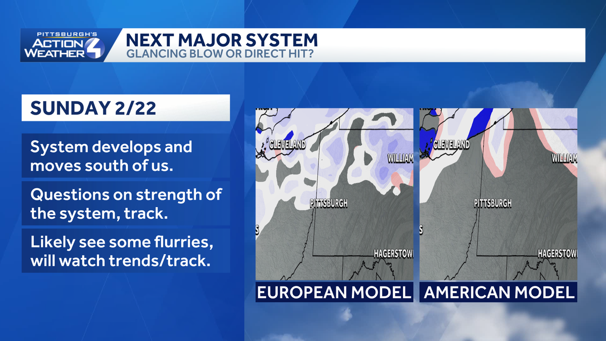
The Pittsburgh’s Action Weather team is tracking a return of chilly temperatures and the potential for light snow on Sunday.The storm’s track will dive to the south of western Pennsylvania and then offshore. The question remains how closely will the storm hug the coast. Our area looks to be on the fringe of the snow. Forecast models are still showing different outcomes, especially for those in the Mid-Atlantic region.Forecast confidenceTiming – High: Sunday, especially during the afternoon and eveningStorm track – Moderate: How far south does the storm dip? How far offshore will it go?Precipitation type – High: All snow, high temperatures in the mid 30sTotal – Moderate: This looks to be a light event, but it is still too early to predict exact amounts. Model comparisonEuropean model: All snow, and general light snow, for western Pennsylvania. The low emerges near the Outer Banks.American model: Mostly light snow with hints of mixing across southwestern Pennsylvania. The low is slightly “deeper,” or stronger. A greater portion of the storm is offshore.Next stepsConfidence and model agreement will improve over the next 48 to 72 hours. Impacts can vary from a glancing blow and a direct hit. Monitor updates from the Pittsburgh’s Action Weather team.
PITTSBURGH —
The Pittsburgh’s Action Weather team is tracking a return of chilly temperatures and the potential for light snow on Sunday.
The storm’s track will dive to the south of western Pennsylvania and then offshore. The question remains how closely will the storm hug the coast. Our area looks to be on the fringe of the snow. Forecast models are still showing different outcomes, especially for those in the Mid-Atlantic region.
Forecast confidence
Timing – High: Sunday, especially during the afternoon and evening
Storm track – Moderate: How far south does the storm dip? How far offshore will it go?
Precipitation type – High: All snow, high temperatures in the mid 30s
Total – Moderate: This looks to be a light event, but it is still too early to predict exact amounts.

Hearst OwnedHearst
We are confident that Sunday’s storm will be light, all snow event.
Model comparison
European model: All snow, and general light snow, for western Pennsylvania. The low emerges near the Outer Banks.

Hearst OwnedHearst
European model forecast guidance for Sunday.
American model: Mostly light snow with hints of mixing across southwestern Pennsylvania. The low is slightly “deeper,” or stronger. A greater portion of the storm is offshore.

Hearst OwnedHearst
The American model forecast guidance for Sunday.
Next steps

Hearst OwnedHearst
Trends are key as we near 48 to 72 out from the storm.
Confidence and model agreement will improve over the next 48 to 72 hours. Impacts can vary from a glancing blow and a direct hit. Monitor updates from the Pittsburgh’s Action Weather team.