
NORTH. BUT THAT HAS BEEN VARIABLE OVER THE PAST COUPLE OF DAYS. ALSO VARIABLE THE SNOW FORECAST FOR SUNDAY. WHAT WE KNOW IS THERE WILL BE SOME RAIN AND SNOW SHOWERS SUNDAY AFTERNOON, MOST LIKELY TRANSITIONING INTO A PERIOD OF LIGHT SNOW SUNDAY EVENING INTO SUNDAY NIGHT. THE OTHER MODEL, THE AMERICAN MODEL, SUPPORTS THE EUROPEAN COMPUTER MODEL SOLUTION IN THAT, BUT IT DOES LOOK A LITTLE CLOSER INLAND, GIVING US A BETTER CHANCE FOR SOME SNOW LATER ON SUNDAY. SO I’D SAY THE CHANCE THAT WE GET 0 TO 2IN OF SNOW IS PRETTY GOOD. 2 TO 4IN LOOKING AT ABOUT A 40 TO 50% CHANCE, AND THEN ANYTHING HIGHER THAN THAT IS LOWER. SO WE’LL WORK ON THOSE TOTALS FOR YOU. AS WE GET CLOSER TO THE EVENT, WE CAN FINE TUNE TIMING AND TEMPERATURES NOT ONLY AT THE SURFACE, BUT IN THE LOW LEVELS OF THE ATMOSPHERE, IN THE CLOUDS, WHERE THOSE SNOWFLAKES DEVELOP. SO THERE’S A LOOK AT THE TEN DAY FORECAST REGINA AFTER A LITTLE BIT OF COOLER WEATHER EAR
Next winter storm could hit south-central Pennsylvania this weekend | Latest models, totals

Updated: 5:51 AM EST Feb 19, 2026
Will a winter storm hit south-central Pennsylvania this weekend? The WGAL News 8 Storm Team is closely tracking the storm, including potential snowfall totals and impacts across the Susquehanna Valley. Timing and trackThe storm’s main window is expected from Sunday evening through early Monday morning. The exact track has yet to be determined this far out. Comparing models:The latest European model shows light snow for the Susquehanna Valley, while the American model is more aggressive and suggests a better chance of snow. Potential snow totalsWhile it is still too early to pin down exact totals, here’s what some models are suggesting:Most models: 0-2 inches (70 percent)Less than half of models: 2-4 inches (40 percent)Few models: 4-6 inches (5 percent)Less than 5 percent of models: Over 6 inchesImpacts for south-central PAMost of south-central Pennsylvania is expected to see snow and rain showers on Sunday afternoon. This will most likely transition into a period of light snow Sunday evening into early Monday. A few localized spots could see a few more inches if the track shifts northward. What we’re tracking Model spread remains notable. With dozens of models to evaluate, snowfall totals could still change. The Storm Team will monitor new model runs and refine the forecast as new data becomes available. SOUTH-CENTRAL PA WEATHER RESOURCES: INTERACTIVE RADAR | ACTIVE WEATHER ALERTS | CURRENT CONDITIONS | HOURLY FORECAST | 10-DAY FORECAST | WEEKEND FORECAST | MAP ROOM | DOWNLOAD THE APP | WEATHER EMAILS
Will a winter storm hit south-central Pennsylvania this weekend?
The WGAL News 8 Storm Team is closely tracking the storm, including potential snowfall totals and impacts across the Susquehanna Valley.
Timing and track
The storm’s main window is expected from Sunday evening through early Monday morning.
The exact track has yet to be determined this far out.
Comparing models:
The latest European model shows light snow for the Susquehanna Valley, while the American model is more aggressive and suggests a better chance of snow.

WGAL News 8 Storm Team
European Model

WGAL News 8 Storm Team
American Model
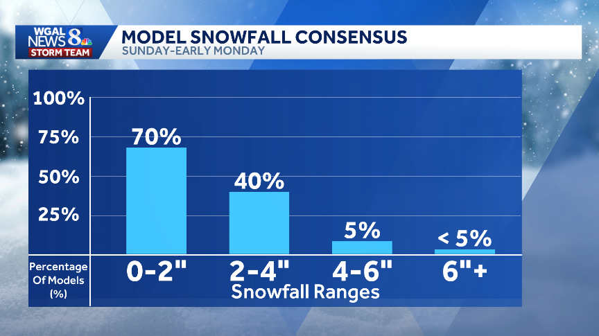
Potential snow totals
While it is still too early to pin down exact totals, here’s what some models are suggesting:
Most models: 0-2 inches (70 percent)Less than half of models: 2-4 inches (40 percent)Few models: 4-6 inches (5 percent)Less than 5 percent of models: Over 6 inches

Impacts for south-central PAMost of south-central Pennsylvania is expected to see snow and rain showers on Sunday afternoon. This will most likely transition into a period of light snow Sunday evening into early Monday. A few localized spots could see a few more inches if the track shifts northward.

What we’re tracking Model spread remains notable. With dozens of models to evaluate, snowfall totals could still change. The Storm Team will monitor new model runs and refine the forecast as new data becomes available.
SOUTH-CENTRAL PA WEATHER RESOURCES: INTERACTIVE RADAR | ACTIVE WEATHER ALERTS | CURRENT CONDITIONS | HOURLY FORECAST | 10-DAY FORECAST | WEEKEND FORECAST | MAP ROOM | DOWNLOAD THE APP | WEATHER EMAILS