Occasional light rain, drizzle, mist and fog are expected to linger across the Lehigh Valley region Thursday morning, ahead of increasing chances for more substantial rain beginning at night and continuing into Friday evening.
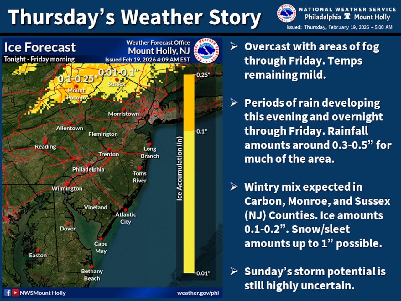
A Winter Weather Advisory is in effect for Carbon, Monroe and Sussex counties from 7 p.m. Thursday through noon Friday as a low-pressure system brings light wintry precipitation to higher elevations across the region.
Both light snow and freezing rain are possible overnight across the advisory area in the Pocono Mountains and northern New Jersey, according to the National Weather Service forecast. Snow and sleet accumulations of up to an inch are expected with ice accumulation around 0.2 of an inch.
Across the broader region, periods of rain are forecast, with the bulk of it falling Thursday night through Friday morning.
The first round of precipitation will arrive late Thursday afternoon and evening, with a second round developing overnight and continuing through Friday.
Total rainfall amounts are expected to range from 0.3 to 0.5 of an inch, with some locally higher amounts possible.
The National Weather Service cautions that light wintry precipitation may cause travel hazards Thursday night and Friday morning, particularly near and north of the Interstate 80 corridor.
Dense fog will continue to linger across the southern Poconos through mid-morning Thursday, with visibility of less than one-half mile common at higher elevations where snow cover remains. Patchy dense fog could bring additional travel hazards to these areas into the morning hours before slow improvement is expected.
Following the passage of this system, milder air arrives for Saturday with highs reaching the mid-40s under partly sunny skies. Areas north of the Lehigh Valley could see a slight chance of light precipitation Saturday.
The region will be on the northwestern edge of a potential coastal storm forecast to be just offshore Sunday and Monday.
Forecast models show significant uncertainty regarding local impacts, with some forecasts suggesting light to moderate snowfall in the New Jersey-Philadelphia metro and Delaware regions, while other guidance shows no snow at all over the entire local area.
Areas south and east of Philadelphia have the greatest potential for impacts from snow and wind Sunday afternoon into early Monday.
At Lehigh Valley International Airport, the weather service forecasts a chance of snow beginning after midnight Saturday, with snow likely Sunday afternoon and the probability of precipitation tapering off into Monday. No accumulation forecast was available Thursday morning from the weather service.
A colder air mass will settle into the region early next week, with high temperatures in the mid 30s to near 40 degrees Monday and Tuesday, and lows in the mid teens and 20s.
Current weather radar