
THE MOUNTAINS. WE’RE WATCHING RAIN SHOWERS RETURNING AS WE HEAD THROUGH THE DAY TODAY. THE HEAVIEST RAIN IS. TONIGHT WILL BE ON IMPACT DAY AS WE WATCH FOR FLOODING TOMORROW, ESPECIALLY ON OUR STREAMS AND RIVERS THAT STILL HAVE ICE ON THEM. ICE JAM FLOODING IS A POSSIBILITY AND WE WILL TURN COLDER AS WE HEAD INTO THE WEEKEND. BECAUSE OF THE CHANCE OF SEEING ICE JAM FLOODING. A FLOOD WATCH IS IN EFFECT FOR EVERYBODY NORTH AND EAST OF THE CITY OF PITTSBURGH, AND BEAVER COUNTY MAY BE ADDED AS WE’RE WATCHING THE CHRONICLE AND CHIQUES CREEK. SO IF YOU LIVE NEAR A STREAM OR RIVER THAT HAS ICE, YOU WANT TO WATCH IT. ESPECIALLY ONCE WE GET TO TOMORROW MORNING. OUR FIRST ROUND OF SHOWERS IS BEGINNING TO LIFT NORTHWARD OUT OF WEST VIRGINIA, CROSSING I-68 NOW, AND WE’LL WATCH FOR A COUPLE OF PASSING SHOWERS AS WE HEAD THROUGH THE AFTERNOON. THE HEAVIEST RAIN IS HERE TONIGHT. WE’RE ON PACE FOR 60 SPOTS SOUTH OF THE CITY. ALREADY THERE. 60 AGAIN TOMORROW WITH RAIN ENDING BEFORE SUNRISE. COLDER THIS WEEKEND WITH A FLURRY. CHANCE FOR US ON SUNDAY. THAT WILL LINGER INTO MONDAY AS WELL. TEMPERATURE OF 33 ON MONDAY, 34 ON TUESDAY. WE’RE BACK INTO THE 40S AS WE HEAD INTO THE BACK PART OF NEXT WEEK. WITH RAIN CHANCES RETURNING WEDNESDAY AND INTO THURSDAY. SO AGAIN, WE’LL WATCH FOR SHOWERS. WE’RE KIND OF ARRIVING OVER THE NEXT FEW HOURS. THESE WILL GENERALLY BE LIGHT BUT QUICK MOVING AS WE HEAD THROUGH THE REST OF THE AFTERNOON. THE HEAVIEST RAIN IS HERE AFTER 10:00. HERE’S 1:00 TOMORROW MORNING WHERE THERE COULD BE POCKETS OF HEAVIER RAIN, PERHAPS EVEN A RUMBLE OR TWO OF THUNDER AS WELL. THIS WILL PUSH OFF TO THE EAST AND WILL CLEAR BY THE TIME WE GET TO SUNRISE ON FRIDAY. SO OUT THE DOOR. WORK AND SCHOOL SHOULD BE DRY. THERE COULD BE THOUGH, AN AREA OR TWO OF FOG WHERE THE HEAVIEST RAIN FALLS. UP TO AN INCH OF RAIN IS POSSIBLE. EVERYBODY ELSE WILL GENERALLY SEE ABOUT A HALF AN INCH, BUT WITH ICE JAMS ON OUR RIVERS, THAT COULD BE ENOUGH TO CAUSE WATER RISES AND POTENTIAL FLOODING AS WELL. THE HEAVIEST RAIN IS LIKELY GOING TO BE SOUTH OF PITTSBURGH. EXCESSIVE RAINFALL OUTLOOK OUT FROM THE WEATHER PREDICTION CENTER HAS THE GREATEST CHANCE OF SEEING SOME HEAVY DOWNPOURS SOUTH OF PITTSBURGH. AND OF COURSE, WE’LL BE MONITORING ALL OF IT AS WE CONTINUE THROUGH THE DAY. ACTION CAM SHOWS I STILL ON THE ALLEGHENY 55 IS THE CURRENT TEMPERATURE AT PITTSBURGH INTERNAT
Flood watch issued in Western Pennsylvania due to dangerous ice jams
The Flood Watch goes through 1 p.m. Friday.

Updated: 2:18 PM EST Feb 19, 2026
A Flood Watch has been issued through 1 p.m. Friday for Armstrong, Butler, Clarion, Fayette, Forest, Indiana, Lawrence, Venango, and Westmoreland counties. Rainfall totals from rain Thursday into Friday will be between one half to one inch.The rain, coupled with rivers and streams still have ice jam concerns, could cause flooding where ice jams do happen on area waterways. Flooding can occur at and upstream of ice jams due to water not being able to move down river. Once the ice jam melts or breaks free, flash flooding can occur downstream as the piled-up water rushes down river.Click here for your full forecast from Pittsburgh’s Action News 4 meteorologist. If you live near a river or stream that still has ice on it, you should monitor your waterway through Friday afternoon for the potential for ice jams and then flooding. Video of Ice Jam in Venango County below: Be aware that even if where you live is ice free, any ice upstream could cause flash flooding downstream if the ice jam gives way all at once. Ice issues may redevelop this weekend and into next week as temperatures drop back to and below freezing, especially if ice is still present on waterways.
PITTSBURGH —
A Flood Watch has been issued through 1 p.m. Friday for Armstrong, Butler, Clarion, Fayette, Forest, Indiana, Lawrence, Venango, and Westmoreland counties.
Rainfall totals from rain Thursday into Friday will be between one half to one inch.

Hearst Owned
Flood Watch for most of Western PA through Friday afternoon.
The rain, coupled with rivers and streams still have ice jam concerns, could cause flooding where ice jams do happen on area waterways.
Flooding can occur at and upstream of ice jams due to water not being able to move down river. Once the ice jam melts or breaks free, flash flooding can occur downstream as the piled-up water rushes down river.
Click here for your full forecast from Pittsburgh’s Action News 4 meteorologist.
If you live near a river or stream that still has ice on it, you should monitor your waterway through Friday afternoon for the potential for ice jams and then flooding.
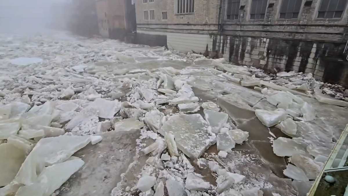
Video of Ice Jam in Venango County below:
Be aware that even if where you live is ice free, any ice upstream could cause flash flooding downstream if the ice jam gives way all at once.
Ice issues may redevelop this weekend and into next week as temperatures drop back to and below freezing, especially if ice is still present on waterways.