
OUR SOUTH. SO THIS IS A PRETTY POTENT SYSTEM COMING THROUGH RIGHT NOW. ENERGY FOR OUR NEXT STORM IN THE ROCKIES. IT CAME ON TO THE CALIFORNIA COAST YESTERDAY. AND THAT WILL CONTINUE TO MOVE EAST ACROSS THE COUNTRY TODAY, TOMORROW, HEADING OUT TO SEA AS WE GET INTO SUNDAY. SO HERE’S A LOOK AT THE WEEKEND FORECAST TODAY. THE RAIN STARTS TO WIND DOWN RIGHT DURING OR SHORTLY AFTER THE MORNING RUSH. LATER IN THE DAY WE COULD SEE SOME CLEARING, BUT I DON’T THINK IT HAPPENS UNTIL EVENING, SO DON’T HOLD YOUR BREATH ON THAT ONE. IT WILL BE LATE IN THE DAY WHERE WE GET THAT CLEARING FOR TOMORROW. LOOK, WE CAN SEE SOME SUNSHINE. THAT WILL BE A NICE TREAT. SO A MIX OF CLOUDS AND SUN. WE WON’T HAVE TO DEAL WITH FOG. AND WE’RE NOT LOOKING AT ANY AIR QUALITY ALERTS EITHER. AS WE HEAD INTO SATURDAY. FOR SUNDAY, THAT AREA OF LOW PRESSURE MOVES OFFSHORE. AND THEN FOR US, WE START TO SEE SOME LIGHT SNOW DEVELOP SUNDAY MORNING THROUGH SUNDAY AFTERNOON. SO WE’RE STILL WORKING ON THE TIMING HERE. I WOULD SAY LATE MORNING INTO THE EARLY AFTERNOON. THAT’S WHEN WE START TO SEE SOME SNOW DEVELOP. STILL NOT GOING TO RULE OUT SOME RAIN MIXING IN OR A LITTLE BIT OF SLEET AT TIMES. AND THEN THAT SNOW WILL CONTINUE ALL THE WAY THROUGH SUNDAY NIGHT. WRAPPING UP MONDAY MORNING. SO IT LOOKS LIKE A LOW IMPACT EVENT FOR US BECAUSE SURFACE TEMPERATURES ON SUNDAY SHOULD BE ABOVE FREEZING. SO THAT LEADS TO WET OR SLUSHY ROADS DURING THE DAY AND THEN SLUSHY TO POSSIBLY SNOWY ROADS OVERNIGHT MONDAY SUNDAY INTO EARLY MONDAY. SO THAT’S WHAT WE’RE GOING TO BE WATCHING OUT FOR. POTENTIAL OUTCOMES HERE. WE’RE LOOKING AT A COATING TO TWO AS BEING VERY LIKELY 2 TO 4 IN THE POSSIBLE RANGE. AND THEN ANYTHING HIGHER THAN THAT HAS A MUCH LESS LIKELIHOOD. AND WE’LL HAVE A SNOW TOTAL MAP FOR YOU COMING UP. HERE’S MY TEN DAY. HERE IT IS. LOOK AT YOUR TEN DAY FORECAST. IT SAYS IT’S FRIDAY I DON’T WANT TO COME OUT HERE. WE GO INTO THE WEEKEND 36 ON SUNDAY 36 ON MONDAY. IT WILL BE BLUSTERY AND COLD. TUESDAY ALSO LOOKS QUITE WINDY
WEEKEND STORM: How much snow is possible in south-central Pennsylvania?

Updated: 6:32 AM EST Feb 20, 2026
A winter storm is set to move through the region this weekend, but how much snow could it bring to south-central Pennsylvania? The WGAL News 8 Storm Team is closely tracking the storm and has declared Sunday an Impact Day.Storm Timing Timeline, track: The system moved onshore from the Pacific on Thursday and is crossing the Rockies before tracking east across the country and heading out to sea. Sunday morning/afternoon: As low pressure moves into the Atlantic on Sunday, light snow is expected to develop across the Susquehanna Valley Sunday morning into the afternoon. Wintry mix possible: Snow may briefly mix with rain or sleet at times on Sunday. Sunday night/Monday morning: Snow continues Sunday night and tapers Monday morning.Potential snow totalsWhile it is still too early to pin down exact totals, here’s the probability of various snow ranges:Coating to 2 inches: Very likely 2 to 4 inches: Possible 4 to 6 inches: Unlikely 6 inches or more: Very unlikely Impacts for south-central PA Overall impact: Likely a lower-impact event since surface temperatures should stay above freezing for much of the day.Travel impacts: Roads may be wet to slushy on Sunday, with slushy or snowy spots possible Sunday night into early Monday. What we’re tracking Model spread of snowfall is narrowing. The Storm Team will issue a snow map on Friday evening. The Storm Team will refine the start and end times of the storm as high-resolution details come into view. SOUTH-CENTRAL PA WEATHER RESOURCES: INTERACTIVE RADAR | ACTIVE WEATHER ALERTS | CURRENT CONDITIONS | HOURLY FORECAST | 10-DAY FORECAST | WEEKEND FORECAST | MAP ROOM | DOWNLOAD THE APP | WEATHER EMAILS
A winter storm is set to move through the region this weekend, but how much snow could it bring to south-central Pennsylvania?
The WGAL News 8 Storm Team is closely tracking the storm and has declared Sunday an Impact Day.
Storm Timing Timeline, track: The system moved onshore from the Pacific on Thursday and is crossing the Rockies before tracking east across the country and heading out to sea. Sunday morning/afternoon: As low pressure moves into the Atlantic on Sunday, light snow is expected to develop across the Susquehanna Valley Sunday morning into the afternoon. Wintry mix possible: Snow may briefly mix with rain or sleet at times on Sunday. Sunday night/Monday morning: Snow continues Sunday night and tapers Monday morning.

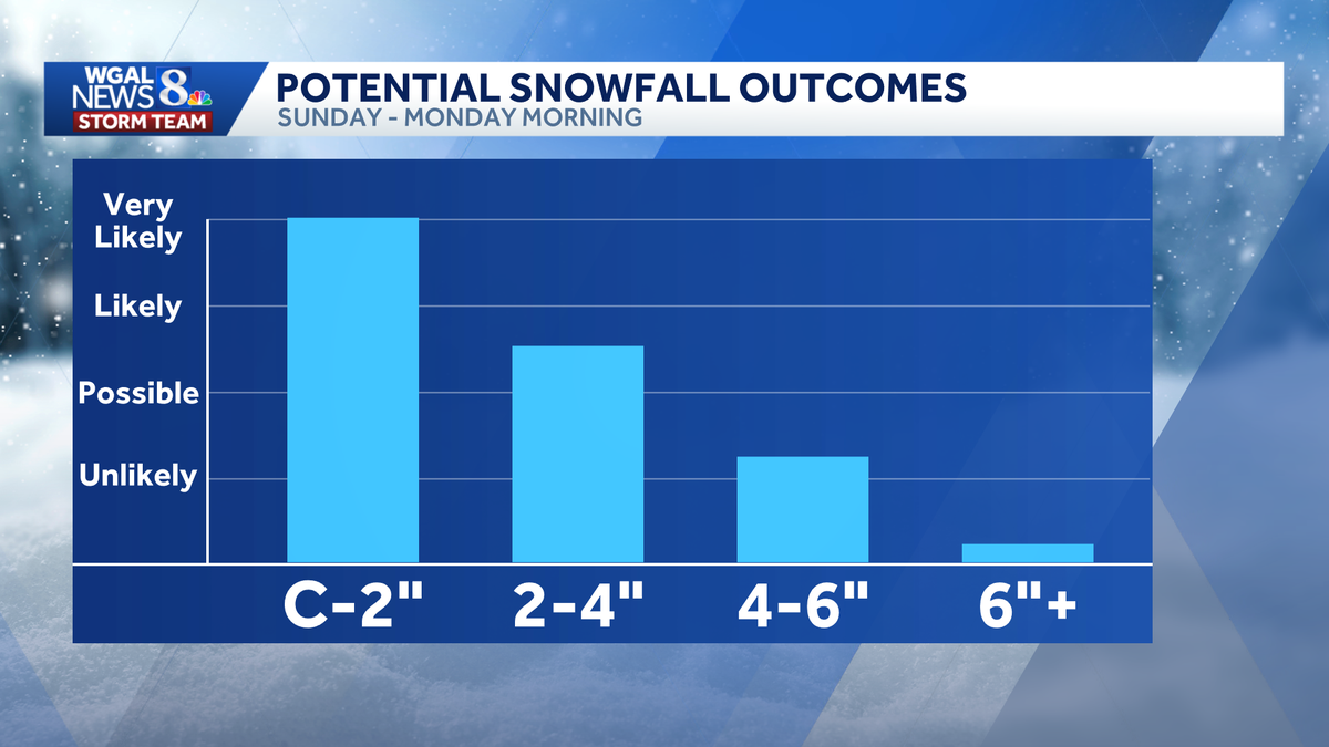
Potential snow totals
While it is still too early to pin down exact totals, here’s the probability of various snow ranges:
Coating to 2 inches: Very likely 2 to 4 inches: Possible 4 to 6 inches: Unlikely
6 inches or more: Very unlikely


Impacts for south-central PA Overall impact: Likely a lower-impact event since surface temperatures should stay above freezing for much of the day.Travel impacts: Roads may be wet to slushy on Sunday, with slushy or snowy spots possible Sunday night into early Monday.

What we’re tracking Model spread of snowfall is narrowing. The Storm Team will issue a snow map this evening.
The Storm Team will refine start and end time of the storm, as high-resolution details come into view.
SOUTH-CENTRAL PA WEATHER RESOURCES: INTERACTIVE RADAR | ACTIVE WEATHER ALERTS | CURRENT CONDITIONS | HOURLY FORECAST | 10-DAY FORECAST | WEEKEND FORECAST | MAP ROOM | DOWNLOAD THE APP | WEATHER EMAILS