
WINTER STORM WATCH issued for this weekend
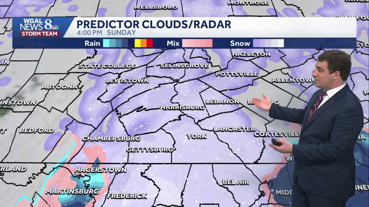
WE’RE SORT OF MELTING WHEN THE TEMPERATURES ROSE. NOW THE WGAL NEWS EIGHT STORM TEAM FORECAST WITH METEOROLOGIST MIKE SUSKO. FRIDAY AFTERNOON THE RAIN IS MOVING OUT ACROSS THE AREA, BUT WE STILL HAVE A LITTLE BIT OF THAT FOG AND MIST IN PARTS OF THE REGION HERE, MAINLY IN LANCASTER COUNTY, AS WELL AS DAUPHIN AND LEBANON COUNTY. BUT THAT FOG IS FOR EVERYBODY. OUR ATTENTION NOW TURNS TO THE WINTER STORM FOR THE WEEKEND. HERE, RIGHT NOW, LOCATED OVER THE FOUR CORNERS REGION OF THE ROCKIES AND DOESN’T LOOK LIKE MUCH. BUT AS IT GETS GOING, IT MOVES FURTHER TO THE EAST IS EXPECTED TO DEVELOP. NOW WHAT WE CAN EXPECT SUNDAY AND INTO MONDAY IS WET TO SLUSHY ROADS HERE FOR PARTS OF THE DAY, WITH SNOW COVERED ROADS EXPECTED SUNDAY NIGHT. WE DO ANTICIPATE MODERATE TRAVEL DISRUPTIONS, ESPECIALLY SUNDAY NIGHT HERE, AS THAT’S WHEN WE EXPECT THE HEAVIER SNOW TO OCCUR. AT THIS POINT, VISIBILITY WILL BE FAIR. OBVIOUSLY WITH SNOW COMING DOWN, THAT’S GOING TO LOWER YOUR VISIBILITY AS WELL. POWER OUTAGES NOT REALLY CONCERNED WITH THIS ONE FOR OUR AREA AS THE WINDS DON’T LOOK TO BE THAT STRONG. SO LET’S TIME OUT EVERYTHING FOR THE WEEKEND AS WE GO THROUGH THE REST OF THE DAY. TODAY, THAT SYSTEM PULLS AWAY AND WE ARE DRY. SATURDAY. TOMORROW, NICE DAY TO GO OUTSIDE, DO ANYTHING. NOT A PROBLEM. AS WE GO THROUGH YOUR FIRST HALF OF THE WEEKEND. AS WE HEAD INTO SUNDAY, WE ARE WATCHING THAT SYSTEM APPROACH OUR AREA HERE. THIS MODEL WANTS TO BRING A LITTLE BIT OF SNOW HERE SUNDAY MORNING, AND KEEP IN MIND IT’S GOING TO ENCOUNTER SOME DRY AIR, SO IT MAY TAKE A LITTLE BIT TO GET GOING FOR SOME OF YOU HERE. AND THEN IT WILL START TO OVERTAKE THE AREA AS WE GO INTO SUNDAY AFTERNOON. NOTICE THAT RAIN LINE MIX HERE ACROSS THE PARTS OF FRANKLIN COUNTY, EVEN INTO CUMBERLAND COUNTY. WE DO ANTICIPATE THERE’S SOME MIXING AT TIMES THAT’S GOING TO CUT DOWN ON THE TOTALS HERE, AS TEMPERATURES WILL BE RIGHT AROUND, IF NOT ABOVE FREEZING AT POINTS. SO WE DO ANTICIPATE THAT AS WE GO INTO SUNDAY AFTERNOON, SUNDAY EVENING, WE SEE IT FILL IN ACROSS THE AREA HERE, AND THEN IT CONTINUES OVERNIGHT INTO MONDAY MORNING BEFORE BEGINNING TO PULL OFF TO THE EAST HERE, MAYBE EVEN LINGERING AS WE GO INTO PARTS OF MONDAY MORNING THERE AS WELL. SO WE WILL BE KEEPING AN EYE ON THAT. BUT IN TERMS OF SNOWFALL AT THE MOMENT IS VERY LIKELY THAT WE ARE GOING TO BE SEEING MANY REPORTS OF AT LEAST TWO INCHES OF SNOW HERE. ONCE YOU GET UP TO FOUR INCHES, IT’S LIKELY, BUT THEN WE START GETTING A LOWER CHANCES AS YOU GO TOWARDS SIX AND EIGHT INCHES ACROSS THE AREA. KEEP IN MIND FOR WINTER STORM WARNING, YOU NEED FIVE INCHES OR MORE FOR OUR AREA. ANYTHING LESS WOULD BE AN ADVISORY. SO IF YOU’RE WONDERING ABOUT THE ALERTS, THAT’S THE CRITERIA YOU NEED HERE FIVE INCHES OR MORE FOR OUR AREA TO GET THAT WINTER STORM WARNING, INCLUDING IN YORK COUNTY HERE. RIGHT NOW WE HAVE A LOT OF CLOUD COVER IN YORK AND CURRENT CONDITIONS THERE. IT IS CLOUDY ACROSS THE AREA AND WE ARE SEEING THOSE TEMPERATURES RIGHT NOW IN THE UPPER 30S AND LOW 40S FOR THE SUSQUEHANNA VALLEY. AND WHEN YOU HEAD OUT FOR THE REST OF THE DAY TODAY, LIKE I SAID EARLIER, IT’S DRIER. WE’RE GOING TO BE AROUND 42 FOR THAT HIGH. THIS FOG WILL PULL AWAY. THAT MIST IS GOING TO PULL AWAY. AND THEN TONIGHT WE’LL DROP BACK TO AROUND 36 DEGREES HERE FOR THOSE OVERNIGHT LOWS. PARTLY CLOUDY AND BREEZY. THAT WILL HELP STIR THINGS UP A LITTLE BIT AS WE GO INTO TOMORROW MORNING. TOMORROW. CLOUDS AND SUN SEASONABLE HIGH AROUND 44 BEFORE WE GET INTO SUNDAY SYSTEM. HERE, THERE WITH THAT IMPACT DAY THERE 36 DEGREES THE HIGH. AND THAT WILL PLAY A ROLE IN HOW MUCH WE GET AS WELL AS WE HEAD INTO THE NEXT WEEK. A LITTLE BIT OF THIS LINGERING INTO MONDAY MORNING CLEARS OUT BY MONDAY AFTERNOON. 34 THE HIGH ON TUESDAY BACK TO THE 40S WEDNESDAY AND THEN 46 WITH SOME CHANCE OF
The National Weather Service has issued a winter storm watch for much of South-Central Pennsylvania.The watch will be in effect from 5 a.m. Sunday through 1 p.m. Monday for the following Susquehanna Valley counties:Adams CountyDauphin CountyLancaster CountyLebanon CountyYork CountyThe WGAL News 8 Storm Team has designated Sunday as an Impact Day, meaning the weather could disrupt your normal daily schedule or routine. Watches vs warningsKnowing the difference between severe watches and warnings is crucial to helping you and your family stay safe before and during severe weather.A watch means ingredients are in place for severe weather to develop. This means severe weather could happen, and you should have a plan ready in case severe weather develops later in the day.A warning means severe weather is happening, and you need to take action now to protect yourself, others and your property.In addition to watches and warnings, there are outlooks that can be issued days in advance. Different threat levels are given to different areas.Ready, get set, goREADY | If your town is in a severe outlook, be ready. Pay attention to the forecast in the coming hours and days, as severe weather may be possible.GET SET | If a severe weather watch is issued for your town, that means ingredients are present for severe weather to occur. Severe weather is going to be possible.GO | A severe warning has been issued. That means severe weather is happening now. Take cover.Stay weather aware with WGAL’s online toolsRADAR: Track severe weather with WGAL’s interactive radar.LOCATION-BASED ALERTS: Instructions for activating our customized weather alerts are here.CLOSINGS: When severe weather strikes, see if businesses, churches or organizations have closed or delayed.ROAD CLOSURES: Our interactive traffic map is always updated with crashes, construction and road closures. It even has a weather radar overlay.EMAIL ALERTS: We’ll send you daily updates, or just alerts when severe weather is headed your way.HOUR-BY-HOUR: See what you can expect every day with the hourly forecast.WEEKEND WEATHER: Know what to expect before you make your plans.10-DAY FORECAST: Check WGAL’s extended forecast here.
The National Weather Service has issued a winter storm watch for much of South-Central Pennsylvania.
The watch will be in effect from 5 a.m. Sunday through 1 p.m. Monday for the following Susquehanna Valley counties:
Adams CountyDauphin CountyLancaster CountyLebanon CountyYork County
The WGAL News 8 Storm Team has designated Sunday as an Impact Day, meaning the weather could disrupt your normal daily schedule or routine.
Watches vs warnings
Knowing the difference between severe watches and warnings is crucial to helping you and your family stay safe before and during severe weather.
A watch means ingredients are in place for severe weather to develop. This means severe weather could happen, and you should have a plan ready in case severe weather develops later in the day.
A warning means severe weather is happening, and you need to take action now to protect yourself, others and your property.
In addition to watches and warnings, there are outlooks that can be issued days in advance. Different threat levels are given to different areas.
Ready, get set, go
READY | If your town is in a severe outlook, be ready. Pay attention to the forecast in the coming hours and days, as severe weather may be possible.
GET SET | If a severe weather watch is issued for your town, that means ingredients are present for severe weather to occur. Severe weather is going to be possible.
GO | A severe warning has been issued. That means severe weather is happening now. Take cover.