
A weekend of changing weather for Western PA as we go from watching our rivers for ice jam flooding to watching more snow fall.Impact Day Friday for Ice Jam FloodingThe Flood Watch that was in effect has been extended through 9 a.m. Saturday for the Allegheny River Valley. Armstrong, Butler, Clarion, and Venango Counties are included in the watch. Ice jam flooding has happened this morning and continues this afternoon. A Flash Flood Warning is in effect for Foxburg, Emlenton, and points downstream through 7 p.m. Friday.Impact Day Sunday for Light SnowWe are not done with winter yet as temperatures fall this weekend. Snow showers will return Sunday, and as a result, a Winter Storm Watch has been issued for the Laurel Highlands of Westmoreland, Fayette, Monongalia, Preston, and Garrett Counties from Sunday morning through Tuesday morning. Sunday is an Impact Day with snow showers through the day.Not a lot of accumulation is expected right now – one to two inches at most outside of the Laurel Highlands. In the Laurel Highlands, up to six inches of snow will be possible, especially on the western facing slopes and above 1500 feet. Flurries will linger into Monday.The chilly feeling will linger into early next week. More rain, and some snow, will move back into the area by the middle of next week.SATURDAY: More seasonal with some sunshine. High: 46°, low: 31°.SUNDAY – Impact Day: Mostly cloudy with light snow showers. High: 36°, low: 28°. Accumulation generally less than two inches.
PITTSBURGH —
A weekend of changing weather for Western PA as we go from watching our rivers for ice jam flooding to watching more snow fall.
Impact Day Friday for Ice Jam Flooding
The Flood Watch that was in effect has been extended through 9 a.m. Saturday for the Allegheny River Valley. Armstrong, Butler, Clarion, and Venango Counties are included in the watch.

Hearst Owned
Flood Watch continues along the Allegheny River through Saturday morning.
Ice jam flooding has happened this morning and continues this afternoon. A Flash Flood Warning is in effect for Foxburg, Emlenton, and points downstream through 7 p.m. Friday.

Hearst Owned
Flash Flood Warning along the Allegheny River through Friday afternoon.
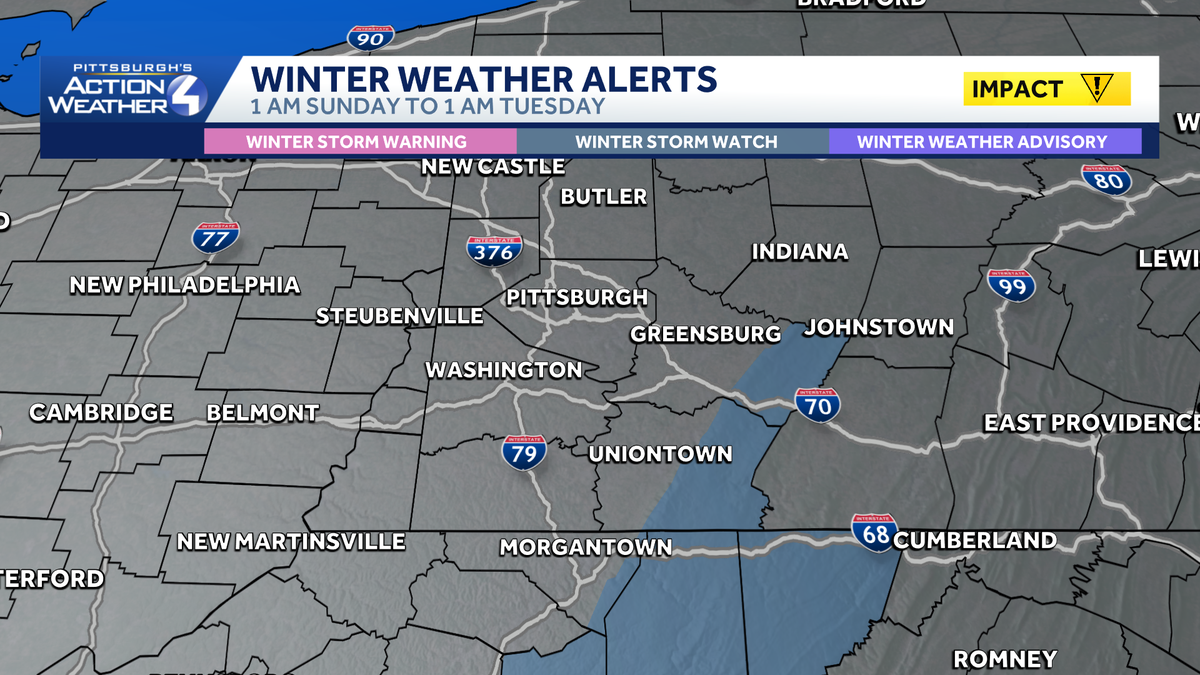
Impact Day Sunday for Light Snow
We are not done with winter yet as temperatures fall this weekend. Snow showers will return Sunday, and as a result, a Winter Storm Watch has been issued for the Laurel Highlands of Westmoreland, Fayette, Monongalia, Preston, and Garrett Counties from Sunday morning through Tuesday morning. Sunday is an Impact Day with snow showers through the day.

Hearst Owned
Winter Storm Watch for the Laurel Highlands from Sunday through Monday.
Not a lot of accumulation is expected right now – one to two inches at most outside of the Laurel Highlands. In the Laurel Highlands, up to six inches of snow will be possible, especially on the western facing slopes and above 1500 feet. Flurries will linger into Monday.
The chilly feeling will linger into early next week.
More rain, and some snow, will move back into the area by the middle of next week.

Hearst Owned
Snow showers return Sunday with warming temperatures next week.
SATURDAY: More seasonal with some sunshine. High: 46°, low: 31°.
SUNDAY – Impact Day: Mostly cloudy with light snow showers. High: 36°, low: 28°. Accumulation generally less than two inches.