
Dry Saturday; Winter Storm Sunday in South Central Pennsylvania
A winter storm will bring accumulating snow to the Susquehanna Valley on Sunday and Sunday night. A Winter Storm Watch has been issued for parts of the Susquehanna Valley from 5 a.m. Sunday – 1 p.m. Monday.
ARE MONITORING IT CLOSELY. THAT’S MEAN LORI. ALL RIGHT AJ THANKS FOR THAT. LET’S GET A CHECK ON THE FORECAST WITH ETHAN. I KNOW THERE’S A STORM THAT YOU’RE KEEPING TRACK OF FOR THE WEEKEND. YEAH THAT’S RIGHT. GET READY FOR A PROLONGED SNOW TO MOVE ACROSS THE SUSQUEHANNA VALLEY ON SUNDAY. WE STILL HAVE A LOT OF MOISTURE OVERHEAD FROM THE RAIN THAT WE HAD THIS MORNING, IN THE FORM OF THAT THICK FOG FOR OUR EASTERN COMMUNITIES. BUT I DO EXPECT VISIBILITY WILL START TO IMPROVE OVERNIGHT TONIGHT. SATURDAY IS DRY, BUT GET READY FOR THAT PROLONGED SNOW TO BE AROUND THROUGHOUT MUCH OF THE VALLEY ON SUNDAY, AND THERE IS A WINTER STORM WATCH ALREADY FOR PARTS OF THE AREA, BUT BECAUSE A DECENT SNOWFALL TOTALS FOR THE VALLEY, WE ARE MAKING SUNDAY AN IMPACT DAY. WE WILL SEE THE STORM PULL AWAY, BUT THE WINTER CHILL WILL REMAIN TO START NEXT WEEK. EVENTUALLY, TEMPERATURES DO START TO CLIMB BACK UP AT OR ABOVE AVERAGE LATE NEXT WEEK. HERE’S A LIVE LOOK OVER LANCASTER. WE’RE LOOKING DOWNTOWN. CAN’T SEE VERY MUCH AS THAT FOG IS THICK IN OUR EASTERN COMMUNITIES RIGHT NOW. 40 DEGREES VISIBILITY IS DOWN TO A QUARTER OF A MILE IN LANCASTER, JUST A HALF MILE IN LEBANON, HALF MILE ALSO IN HARRISBURG. BUT YOU CAN SEE CONDITIONS IMPROVE THE FARTHER WEST YOU GO. AND ALSO TEMPERATURES WARM THE FARTHER WEST YOU GO. 44 RIGHT NOW IN CHAMBERSBURG, WHERE THAT FOG IS THICK, IT’S JUST 14 LANCASTER AND 39 IN LEBANON. SO WE STILL HAVE THAT LINGERING FOG, THE RAIN THAT WE HAD EARLY THIS MORNING, THAT’S NOW MOSTLY IN THE FORM OF SNOW OVER NEW ENGLAND. THAT STORM IS PULLING AWAY. HERE’S SUNDAY’S STORM RIGHT NOW. IT’S BACK OVER THE ROCKIES. IT’S GOING TO DIVE DOWN TOWARDS THE GULF AND PICK UP SOME MOISTURE, AND THEN MOVE TO OUR SOUTH. GOING THROUGH THE DAY ON SUNDAY. BUT CLOSE ENOUGH MUCH OF SUNDAY WE’RE GOING TO SEE STEADY SNOW FALLING ACROSS THE REGION. SO SOME CLEARING STILL FOGGY THIS EVENING. TEMPERATURES NEAR 40 DEGREES. LOWS TONIGHT WILL BE IN THE MID TO UPPER 30S. AND THEN WE’LL SEE A GORGEOUS SATURDAY. LOOK FOR HIGHS TO BE IN THE LOW TO MID 40S AND THEN BEFORE DAWN ON SUNDAY. HERE COMES THAT LIGHT SNOW DEVELOPING FROM WEST TO EAST. COULD BE HEAVY AT TIMES AFTER DARK. STILL NOT RULING OUT SOME RAIN. TRYING TO MIX IN WITH THE SNOW AT TIMES THAT MAY LOWER TOTALS IN SOME LOCATIONS. AND NOTICE THE TEMPERATURES AT OR ABOVE FREEZING AS WE GO THROUGH SUNDAY AFTERNOON. SO WE ALREADY HAVE A WINTER STORM. WATCH FROM ADAMS COUNTY, DAUPHIN COUNTY, AND POINTS OFF TO THE EAST. THAT GOES ALL THE WAY TOWARDS THE JERSEY SHORE. AND IT’S THE JERSEY SHORE WHERE THEY COULD SEE THE MOST SNOW FALL, HIGHEST ACCUMULATIONS AT THE CURRENT TRACK OF THE STORM. SO THERE GOES STORM NUMBER ONE, THANKS TO A DEVELOPING BREEZE, OUR VISIBILITY SHOULD IMPROVE OVERNIGHT TONIGHT. SATURDAY LOOKS LIKE A COMFORTABLE DAY WITH HIGHS IN THE 40S. WE FINALLY SEE SOME SUNSHINE. GET RID OF THAT FOG THAT HAS BEEN PLAGUING US FOR MUCH OF THIS WORKWEEK. WE’LL STOP THE CLOCK HERE AT 1230 IN THE MORNING SUNDAY. I DO EXPECT THE SNOW WILL START MOVING IN FROM WEST TO EAST BEFORE DAWN, AND THEN IT WILL BECOME STEADY IN NATURE THROUGH SUNDAY MORNING, BATTLING TEMPERATURES AT OR ABOVE FREEZING. SO ROADWAYS WILL LIKELY BE WET TO SLUSHY. BUT AFTER SUNSET, THAT’S WHEN WE COULD SEE SOME MODERATE BANDING OF SOME SNOWFALL. NOTICE SOME SLIGHTLY HIGHER BANDING OUT TOWARDS COATESVILLE, TOWARDS ALLENTOWN, AND THEN EVENTUALLY THE SNOW WILL START TAPERING FROM WEST TO EAST EARLY ON MONDAY MORNING. SO HOW MUCH? HERE’S OUR FIRST CALL FOR THE STORM. LOOKING AT 2 TO 5IN OF SNOW. BUT THERE IS A POSSIBILITY FAR SOUTHERN PORTIONS OF YORK COUNTY, SOUTHERN LANCASTER COUNTY TO CHESTER COUNTY, A LITTLE BIT MORE THAN FIVE INCHES, POSSIBLY UP TO EIGHT INCHES. AS YOU GET CLOSER TOWARDS PHILADELPHIA. NOW, ALLOW SOME WIGGLE ROOM FOR THIS FORECAST. WE DO HAVE HIGH CONFIDENCE OF THE TIMING OF THE STORM. STARTS OFF SUNDAY MORNING AND MONDAY MORNING. TRACK LOOKS MODERATE, BUT UNFORTUNATELY TOTALS STILL LOW CONFIDENCE. IF THIS STORM TRACK MOVES ANY 50 MILES IN EITHER LOCATIONS, THAT COULD IMPACT HOW MUCH SNOW WE SEE, AND ALSO WHERE THIS MIX LINE MAY SET UP. SO STAY TUNED. WE’LL CONTINUE TO FINE TUNE THE FORECAST IN THE COMING HOURS, BUT I DO EXPECT THAT SNOW WILL BE OUT THERE THROUGHOUT MUCH OF OUR SUNDAY SUNDAY NIGHT, POSSIBLY LINGERING THROUGH ON MONDAY. IT WILL BE A COLD START TO NEXT WORK WEEK WITH HIGHS ONLY IN THE MID 30S. WE’RE BACK INTO THE 40S BY WEDNESDAY AN
Dry Saturday; Winter Storm Sunday in South Central Pennsylvania
A winter storm will bring accumulating snow to the Susquehanna Valley on Sunday and Sunday night. A Winter Storm Watch has been issued for parts of the Susquehanna Valley from 5 a.m. Sunday – 1 p.m. Monday.

Updated: 6:23 PM EST Feb 20, 2026
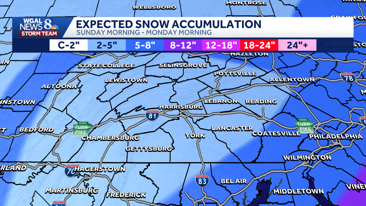
Good evening,Tonight, lows will fall to the mid-30s under partly cloudy skies. It will be breezy overnight, preventing the development of fog.Saturday will feature a mix of clouds and sunshine, along with seasonable highs around 44 degrees. Wind speeds will range between 5-15 mph.WINTER STORM WATCH:The National Weather Service has issued a winter storm watch for parts of the Susquehanna Valley from 5 a.m. Sunday to 1 p.m. Monday for Adams, Berks, Chester, Dauphin, Lancaster, Lebanon, Schuylkill, and York counties. Heavy snow is possible as a winter storm develops off the Mid-Atlantic coast. IMPACT SUNDAY INTO EARLY MONDAY:Low pressure will move off the coast of North Carolina and Virginia early Sunday. Expect light snow to develop in the Susquehanna Valley Sunday morning through early Sunday afternoon. The snow may mix with rain or sleet at times. Surface temperatures will be above freezing during the day, so roads will likely be wet to slushy.The chance of snow continues Sunday night into early Monday. Overnight, roads may be slushy to snowy. The majority of the Susquehanna Valley can expect 2-5″ of snow with the highest totals south & east of I-81. A few locations may pick up 5-8″ in southern York and Lancaster counties.NEXT WEEK:Colder temperatures in the low-to-mid 30s are in store on Monday and Tuesday. Add a blustery breeze, and it will feel like the 20s.Temperatures moderate to the low 40s on Wednesday, and rain chances increase late Wednesday into Thursday. Highs will reach the mid-40s on Thursday.Slightly cooler temperatures are in store for Friday, then the following weekend looks dry and pleasant, with highs in the mid-40s.Have a great day!
Good evening,
Tonight, lows will fall to the mid-30s under partly cloudy skies. It will be breezy overnight, preventing the development of fog.
Saturday will feature a mix of clouds and sunshine, along with seasonable highs around 44 degrees. Wind speeds will range between 5-15 mph.
WINTER STORM WATCH:
The National Weather Service has issued a winter storm watch for parts of the Susquehanna Valley from 5 a.m. Sunday to 1 p.m. Monday for Adams, Berks, Chester, Dauphin, Lancaster, Lebanon, Schuylkill, and York counties. Heavy snow is possible as a winter storm develops off the Mid-Atlantic coast.
IMPACT SUNDAY INTO EARLY MONDAY:
Low pressure will move off the coast of North Carolina and Virginia early Sunday. Expect light snow to develop in the Susquehanna Valley Sunday morning through early Sunday afternoon. The snow may mix with rain or sleet at times. Surface temperatures will be above freezing during the day, so roads will likely be wet to slushy.
The chance of snow continues Sunday night into early Monday. Overnight, roads may be slushy to snowy. The majority of the Susquehanna Valley can expect 2-5″ of snow with the highest totals south & east of I-81. A few locations may pick up 5-8″ in southern York and Lancaster counties.
NEXT WEEK:
Colder temperatures in the low-to-mid 30s are in store on Monday and Tuesday. Add a blustery breeze, and it will feel like the 20s.
Temperatures moderate to the low 40s on Wednesday, and rain chances increase late Wednesday into Thursday. Highs will reach the mid-40s on Thursday.
Slightly cooler temperatures are in store for Friday, then the following weekend looks dry and pleasant, with highs in the mid-40s.
Have a great day!